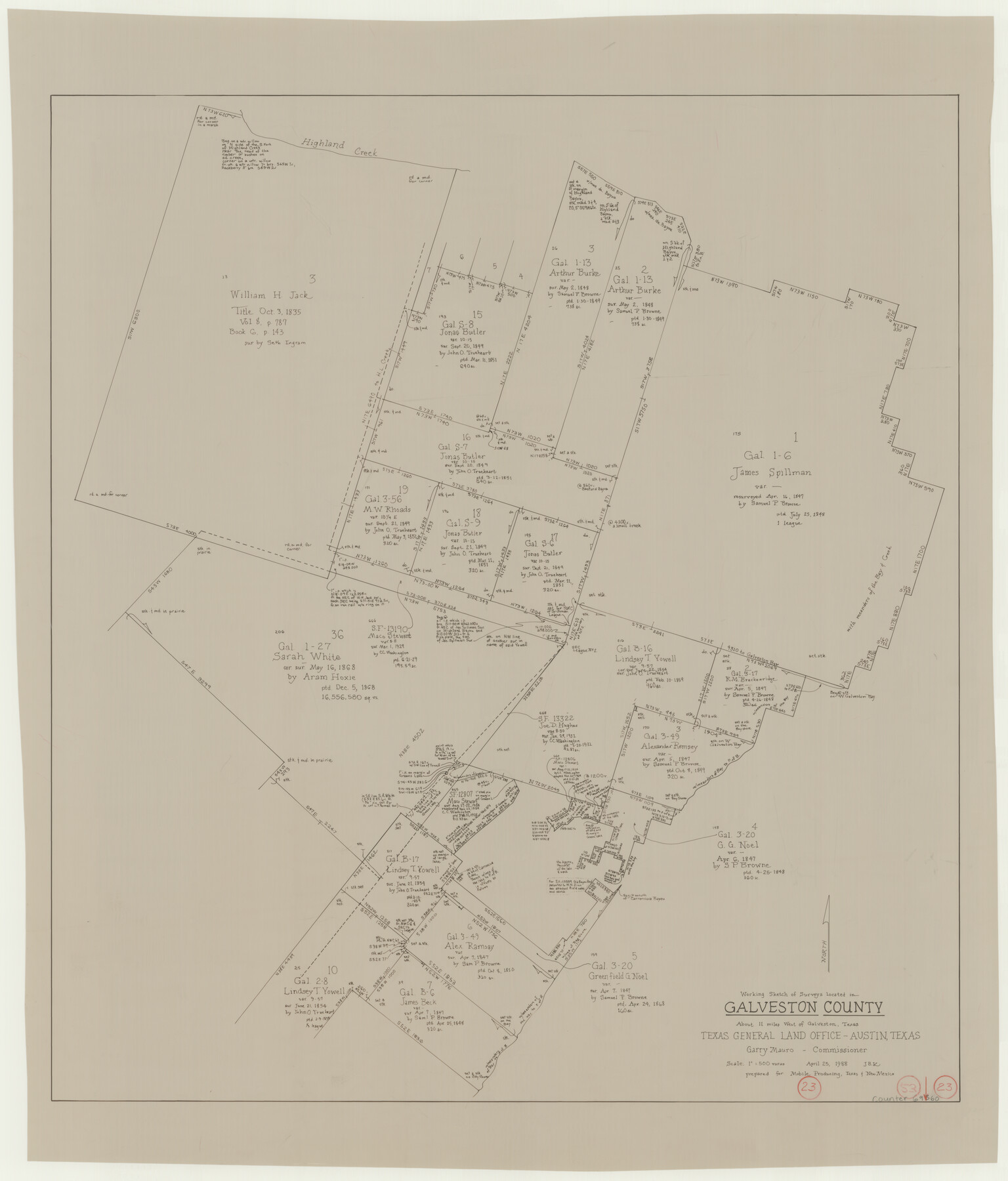
Galveston County Working Sketch 23
-
Map/Doc
69360
-
Collection
General Map Collection
-
Object Dates
4/25/1988 (Creation Date)
-
People and Organizations
Joan Kilpatrick (Draftsman)
-
Counties
Galveston
-
Subjects
Surveying Working Sketch
-
Height x Width
35.8 x 30.6 inches
90.9 x 77.7 cm
-
Scale
1" = 500 varas
Part of: General Map Collection
Smith County Sketch File 4

Print $4.00
- Digital $50.00
Smith County Sketch File 4
1853
Size 10.3 x 8.1 inches
Map/Doc 36752
Sterling County Sketch File D

Print $8.00
- Digital $50.00
Sterling County Sketch File D
Size 11.2 x 8.6 inches
Map/Doc 37157
Comal County Working Sketch 7

Print $20.00
- Digital $50.00
Comal County Working Sketch 7
1950
Size 42.1 x 31.8 inches
Map/Doc 68173
Houston including Bellaire, Bunker Hill, Galena Park, Hedwig, Hilshire, Hunters Creek, Jacinto City, Jersey Village, Missouri City, Pasadena, Piney Point, South Houston, Spring Valley, West University Place and adjoining communities [Recto]
![94179, Houston including Bellaire, Bunker Hill, Galena Park, Hedwig, Hilshire, Hunters Creek, Jacinto City, Jersey Village, Missouri City, Pasadena, Piney Point, South Houston, Spring Valley, West University Place and adjoining communities [Recto], General Map Collection](https://historictexasmaps.com/wmedia_w700/maps/94179.tif.jpg)
Houston including Bellaire, Bunker Hill, Galena Park, Hedwig, Hilshire, Hunters Creek, Jacinto City, Jersey Village, Missouri City, Pasadena, Piney Point, South Houston, Spring Valley, West University Place and adjoining communities [Recto]
Size 27.1 x 42.6 inches
Map/Doc 94179
Callahan County Sketch File 6a

Print $24.00
- Digital $50.00
Callahan County Sketch File 6a
Size 8.0 x 6.8 inches
Map/Doc 35860
Real County Working Sketch 12

Print $20.00
- Digital $50.00
Real County Working Sketch 12
1931
Size 19.1 x 18.6 inches
Map/Doc 71904
The Rand-McNally New Commercial Atlas Map of Texas

The Rand-McNally New Commercial Atlas Map of Texas
1914
Size 29.4 x 40.7 inches
Map/Doc 88745
Burnet County Working Sketch 2

Print $20.00
- Digital $50.00
Burnet County Working Sketch 2
1953
Size 18.3 x 29.1 inches
Map/Doc 67845
Upton County Rolled Sketch 43

Print $40.00
- Digital $50.00
Upton County Rolled Sketch 43
Size 27.1 x 54.2 inches
Map/Doc 10057
Flight Mission No. DAG-18K, Frame 74, Matagorda County

Print $20.00
- Digital $50.00
Flight Mission No. DAG-18K, Frame 74, Matagorda County
1952
Size 18.5 x 22.4 inches
Map/Doc 86367
Polk County Sketch File 5

Print $2.00
- Digital $50.00
Polk County Sketch File 5
Size 8.0 x 7.0 inches
Map/Doc 34128
Throckmorton County Working Sketch Graphic Index

Print $20.00
- Digital $50.00
Throckmorton County Working Sketch Graphic Index
1943
Size 44.6 x 36.3 inches
Map/Doc 76713
You may also like
Louisiana and Texas Intracoastal Waterway, Sabine River Galveston Bay Section Survey

Print $20.00
- Digital $50.00
Louisiana and Texas Intracoastal Waterway, Sabine River Galveston Bay Section Survey
1927
Size 30.7 x 43.0 inches
Map/Doc 61838
Flight Mission No. DQN-2K, Frame 95, Calhoun County

Print $20.00
- Digital $50.00
Flight Mission No. DQN-2K, Frame 95, Calhoun County
1953
Size 18.6 x 22.3 inches
Map/Doc 84285
Harris County Historic Topographic 29

Print $20.00
- Digital $50.00
Harris County Historic Topographic 29
1915
Size 29.1 x 23.0 inches
Map/Doc 65840
[Sketch for Mineral Application 21493 - Clay County]
![65625, [Sketch for Mineral Application 21493 - Clay County], General Map Collection](https://historictexasmaps.com/wmedia_w700/maps/65625-1.tif.jpg)
Print $40.00
- Digital $50.00
[Sketch for Mineral Application 21493 - Clay County]
Size 62.4 x 34.8 inches
Map/Doc 65625
Dimmit County Working Sketch 6

Print $20.00
- Digital $50.00
Dimmit County Working Sketch 6
1922
Size 23.0 x 16.7 inches
Map/Doc 68667
Somervell County

Print $20.00
- Digital $50.00
Somervell County
1884
Size 29.5 x 31.3 inches
Map/Doc 63041
Matagorda County Working Sketch 31

Print $20.00
- Digital $50.00
Matagorda County Working Sketch 31
1982
Size 17.2 x 46.9 inches
Map/Doc 70889
Dawson County Sketch File 5

Print $38.00
- Digital $50.00
Dawson County Sketch File 5
1924
Size 13.4 x 8.9 inches
Map/Doc 20509
Williamson County Rolled Sketch 5

Print $20.00
- Digital $50.00
Williamson County Rolled Sketch 5
1940
Size 23.7 x 34.5 inches
Map/Doc 8263
[Anderson County]
![5051, [Anderson County], General Map Collection](https://historictexasmaps.com/wmedia_w700/maps/5051-GC.tif.jpg)
Print $20.00
- Digital $50.00
[Anderson County]
1848
Size 26.0 x 19.9 inches
Map/Doc 5051
Reeves County Rolled Sketch 19

Print $20.00
- Digital $50.00
Reeves County Rolled Sketch 19
1969
Size 23.8 x 21.5 inches
Map/Doc 7488
Burleson County

Print $20.00
- Digital $50.00
Burleson County
1920
Size 38.0 x 45.0 inches
Map/Doc 4790