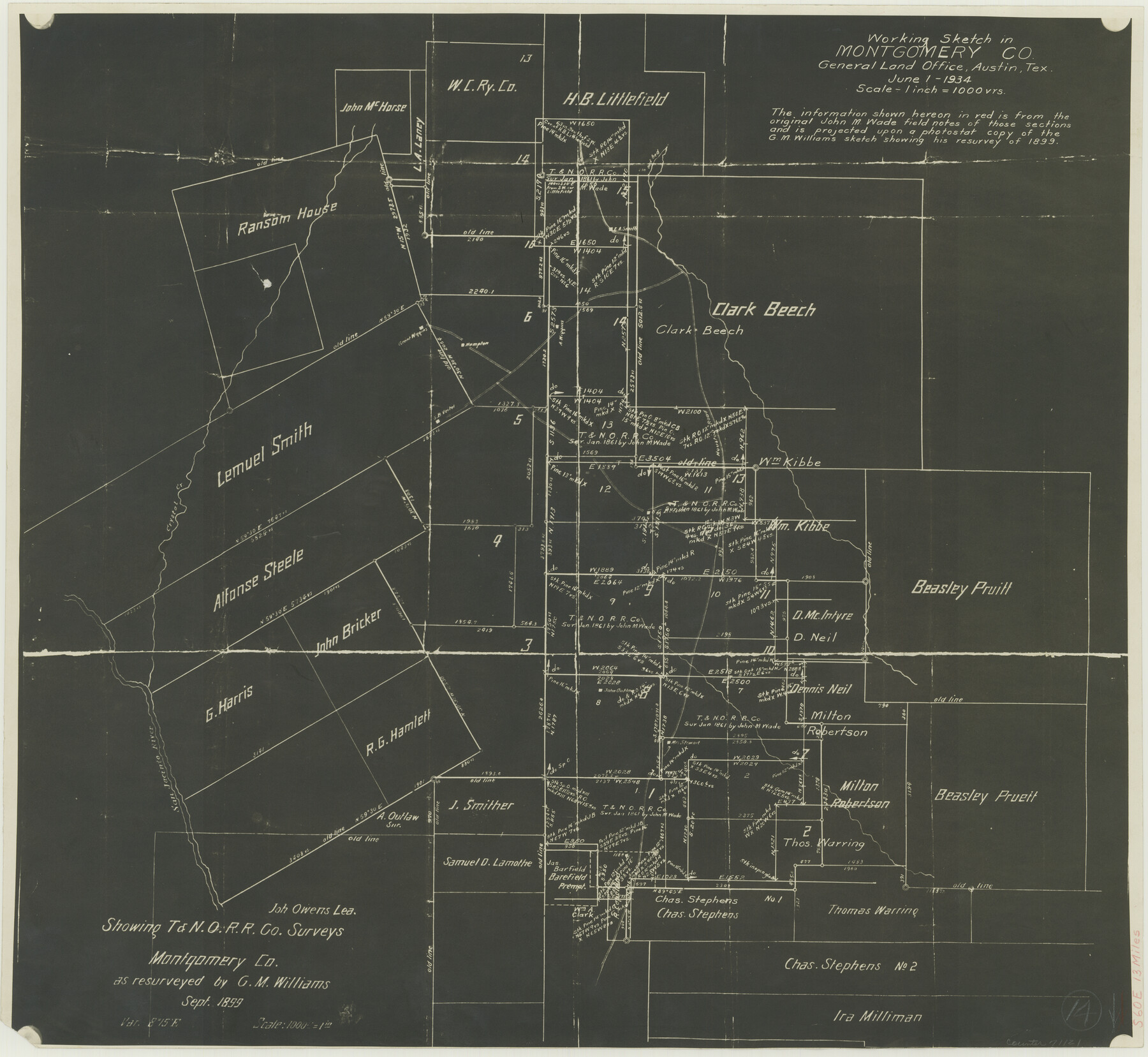
Montgomery County Working Sketch 14
-
Map/Doc
71121
-
Collection
General Map Collection
-
Object Dates
6/1/1934 (Creation Date)
-
Counties
Montgomery
-
Subjects
Surveying Working Sketch
-
Height x Width
18.5 x 20.1 inches
47.0 x 51.1 cm
-
Scale
1" = 1000 varas
Part of: General Map Collection
Burleson County Sketch File 5

Print $4.00
- Digital $50.00
Burleson County Sketch File 5
Size 12.9 x 8.3 inches
Map/Doc 16649
Moore County Rolled Sketch 3

Print $20.00
- Digital $50.00
Moore County Rolled Sketch 3
Size 12.3 x 15.3 inches
Map/Doc 6823

Harris County Sketch File AA3

Print $8.00
- Digital $50.00
Harris County Sketch File AA3
Size 8.2 x 8.5 inches
Map/Doc 25326
Harrison County State Real Property Sketch 1

Print $20.00
- Digital $50.00
Harrison County State Real Property Sketch 1
1986
Size 24.2 x 25.4 inches
Map/Doc 61666
Bexar County Working Sketch 11

Print $20.00
- Digital $50.00
Bexar County Working Sketch 11
1964
Size 38.6 x 36.9 inches
Map/Doc 67327
Colorado River, LaGrange Sheet

Print $20.00
- Digital $50.00
Colorado River, LaGrange Sheet
1934
Size 37.8 x 32.9 inches
Map/Doc 65302
Nueces County NRC Article 33.136 Location Key Sheet

Print $20.00
- Digital $50.00
Nueces County NRC Article 33.136 Location Key Sheet
1975
Size 27.5 x 23.0 inches
Map/Doc 88589

Schleicher County

Print $40.00
- Digital $50.00
Schleicher County
1940
Size 39.7 x 55.9 inches
Map/Doc 95636
Freestone County Sketch File 15

Print $4.00
- Digital $50.00
Freestone County Sketch File 15
Size 6.3 x 8.2 inches
Map/Doc 23070
[Surveys along the Red River made for titles under Radford Berry, Commissioner]
![32, [Surveys along the Red River made for titles under Radford Berry, Commissioner], General Map Collection](https://historictexasmaps.com/wmedia_w700/maps/32.tif.jpg)
Print $20.00
- Digital $50.00
[Surveys along the Red River made for titles under Radford Berry, Commissioner]
Size 23.3 x 19.5 inches
Map/Doc 32
You may also like
Flight Mission No. CUG-2P, Frame 24, Kleberg County

Print $20.00
- Digital $50.00
Flight Mission No. CUG-2P, Frame 24, Kleberg County
1956
Size 18.4 x 22.3 inches
Map/Doc 86188
Rockwall County Boundary File 7

Print $4.00
- Digital $50.00
Rockwall County Boundary File 7
Size 11.5 x 8.8 inches
Map/Doc 58426
El Paso County Working Sketch 57

Print $20.00
- Digital $50.00
El Paso County Working Sketch 57
Size 37.5 x 37.4 inches
Map/Doc 69079

Briscoe County

Print $20.00
- Digital $50.00
Briscoe County
1881
Size 26.8 x 21.5 inches
Map/Doc 3333
Comanche County Working Sketch 21

Print $20.00
- Digital $50.00
Comanche County Working Sketch 21
1973
Size 28.0 x 26.1 inches
Map/Doc 68155
[Map showing J. H. Gibson Blocks D and DD and Double Lake Corner]
![92015, [Map showing J. H. Gibson Blocks D and DD and Double Lake Corner], Twichell Survey Records](https://historictexasmaps.com/wmedia_w700/maps/92015-1.tif.jpg)
Print $20.00
- Digital $50.00
[Map showing J. H. Gibson Blocks D and DD and Double Lake Corner]
Size 36.4 x 33.6 inches
Map/Doc 92015
Bosque County Working Sketch 1

Print $20.00
- Digital $50.00
Bosque County Working Sketch 1
Size 16.3 x 13.7 inches
Map/Doc 67434
Bowie County Working Sketch 15

Print $20.00
- Digital $50.00
Bowie County Working Sketch 15
1960
Size 34.5 x 25.8 inches
Map/Doc 67419
The Newest Land Of Promise - The Pecos Valley in Texas

Print $20.00
- Digital $50.00
The Newest Land Of Promise - The Pecos Valley in Texas
1900
Size 17.8 x 22.8 inches
Map/Doc 97037
[Sketch of Potter County Road, North of River]
![93058, [Sketch of Potter County Road, North of River], Twichell Survey Records](https://historictexasmaps.com/wmedia_w700/maps/93058-1.tif.jpg)
Print $3.00
- Digital $50.00
[Sketch of Potter County Road, North of River]
Size 9.6 x 15.0 inches
Map/Doc 93058
Crockett County Working Sketch 31

Print $20.00
- Digital $50.00
Crockett County Working Sketch 31
1924
Size 37.2 x 33.5 inches
Map/Doc 68364