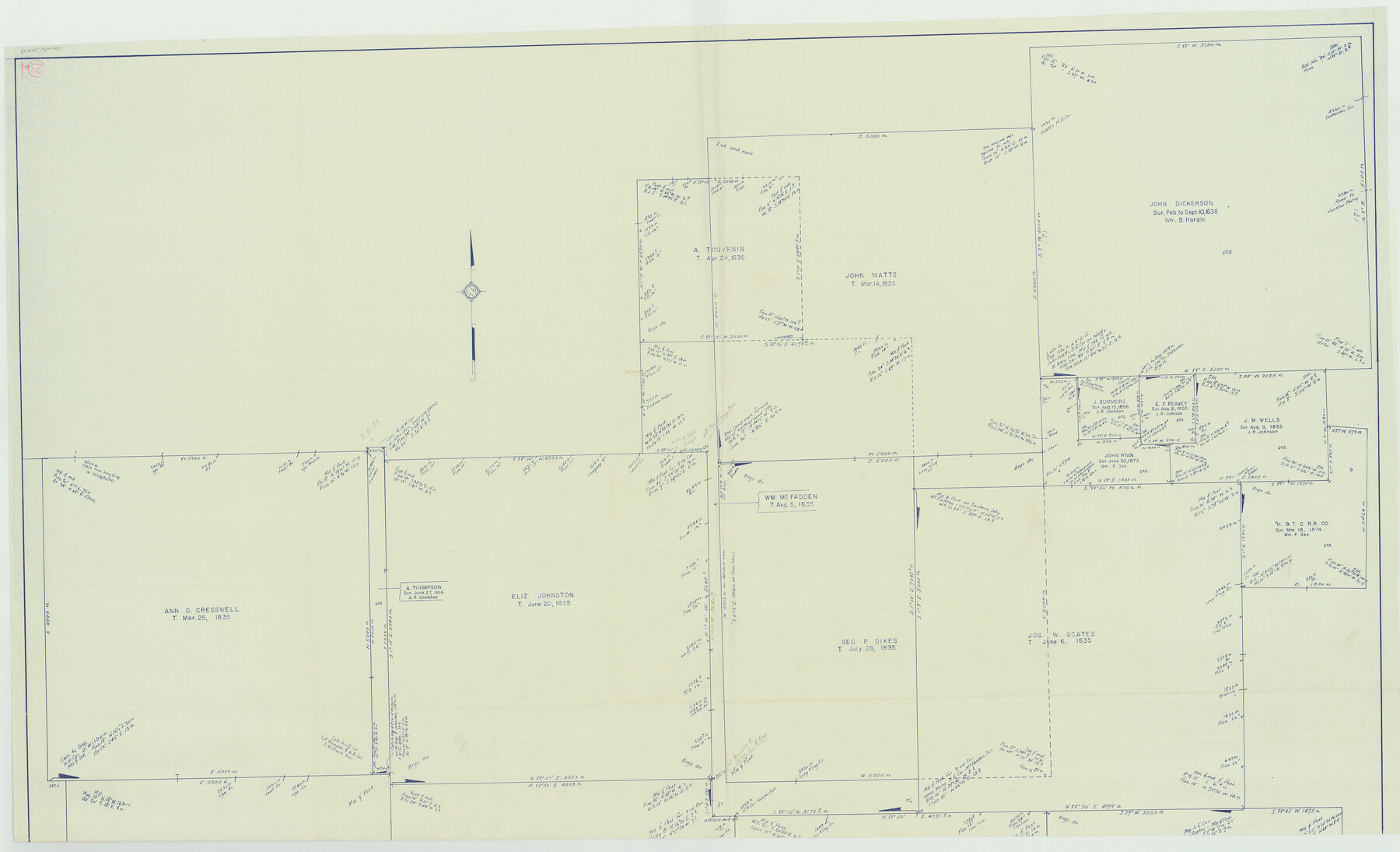
Polk County Working Sketch 23a
-
Map/Doc
71638
-
Collection
General Map Collection
-
Object Dates
2/13/1957 (Creation Date)
-
People and Organizations
Otto G. Kurio (Draftsman)
-
Counties
Polk
-
Subjects
Surveying Working Sketch
-
Height x Width
32.9 x 54.1 inches
83.6 x 137.4 cm
-
Scale
1" = 400 varas
-
Comments
Segment 1; for segment 2 see counter No. 71639.
Related maps
Polk County Working Sketch 23b

Print $40.00
- Digital $50.00
Polk County Working Sketch 23b
1957
Size 28.8 x 54.6 inches
Map/Doc 71639
Part of: General Map Collection
Fisher County Working Sketch Graphic Index

Print $20.00
- Digital $50.00
Fisher County Working Sketch Graphic Index
1944
Size 46.9 x 41.4 inches
Map/Doc 76542
Terry County Sketch File 12

Print $20.00
- Digital $50.00
Terry County Sketch File 12
Size 10.9 x 43.2 inches
Map/Doc 10396
Loving County Working Sketch 17

Print $20.00
- Digital $50.00
Loving County Working Sketch 17
1976
Size 43.5 x 38.2 inches
Map/Doc 70651
Nueces County Sketch File 25B

Print $20.00
- Digital $50.00
Nueces County Sketch File 25B
1894
Size 17.6 x 24.6 inches
Map/Doc 42183
Comal County Working Sketch 8

Print $20.00
- Digital $50.00
Comal County Working Sketch 8
1971
Size 41.6 x 25.6 inches
Map/Doc 68174
Menard County Sketch File 11

Print $8.00
- Digital $50.00
Menard County Sketch File 11
1892
Size 12.8 x 8.3 inches
Map/Doc 31496
Upton County Working Sketch 41

Print $40.00
- Digital $50.00
Upton County Working Sketch 41
1960
Size 40.4 x 54.2 inches
Map/Doc 69537
Crockett County Rolled Sketch 88N

Print $89.00
- Digital $50.00
Crockett County Rolled Sketch 88N
1973
Size 10.6 x 15.5 inches
Map/Doc 44132
DeWitt County Working Sketch 3

Print $20.00
- Digital $50.00
DeWitt County Working Sketch 3
1957
Size 35.5 x 44.6 inches
Map/Doc 68593
Duval County Sketch File 53

Print $4.00
- Digital $50.00
Duval County Sketch File 53
1937
Size 11.6 x 7.3 inches
Map/Doc 21416
[Right of Way & Track Map, The Texas & Pacific Ry. Co. Main Line]
![64664, [Right of Way & Track Map, The Texas & Pacific Ry. Co. Main Line], General Map Collection](https://historictexasmaps.com/wmedia_w700/maps/64664.tif.jpg)
Print $20.00
- Digital $50.00
[Right of Way & Track Map, The Texas & Pacific Ry. Co. Main Line]
Size 11.0 x 18.5 inches
Map/Doc 64664
Bexar County Sketch File 47

Print $40.00
- Digital $50.00
Bexar County Sketch File 47
1896
Size 9.9 x 19.6 inches
Map/Doc 10925
You may also like
Maverick County Working Sketch 1

Print $20.00
- Digital $50.00
Maverick County Working Sketch 1
1906
Size 11.5 x 11.1 inches
Map/Doc 70893
[Sketch for Mineral Application 24072, San Jacinto River]
![65585, [Sketch for Mineral Application 24072, San Jacinto River], General Map Collection](https://historictexasmaps.com/wmedia_w700/maps/65585.tif.jpg)
Print $20.00
- Digital $50.00
[Sketch for Mineral Application 24072, San Jacinto River]
1929
Size 21.7 x 11.1 inches
Map/Doc 65585
Cass County Working Sketch 37

Print $20.00
- Digital $50.00
Cass County Working Sketch 37
1982
Size 26.8 x 31.8 inches
Map/Doc 67940
Flight Mission No. BRE-2P, Frame 53, Nueces County

Print $20.00
- Digital $50.00
Flight Mission No. BRE-2P, Frame 53, Nueces County
1956
Size 18.4 x 22.2 inches
Map/Doc 86755
Map showing lands of D. Sullivan known as Santa Rosa Ranch, situated in Cameron and Hidalgo Counties, Texas

Print $20.00
- Digital $50.00
Map showing lands of D. Sullivan known as Santa Rosa Ranch, situated in Cameron and Hidalgo Counties, Texas
1905
Size 26.8 x 27.3 inches
Map/Doc 4451
Supreme Court of the United States, October Term, 1923, No. 15, Original - The State of Oklahoma, Complainant vs. The State of Texas, Defendant, The United States, Intervener; Report of the Boundary Commissioners

Print $20.00
- Digital $50.00
Supreme Court of the United States, October Term, 1923, No. 15, Original - The State of Oklahoma, Complainant vs. The State of Texas, Defendant, The United States, Intervener; Report of the Boundary Commissioners
1923
Size 34.2 x 33.9 inches
Map/Doc 75133
Map of the Western Part of Bexar District

Print $40.00
- Digital $50.00
Map of the Western Part of Bexar District
1849
Size 63.5 x 21.6 inches
Map/Doc 87375

Lee County Sketch File 8

Print $6.00
- Digital $50.00
Lee County Sketch File 8
1838
Size 12.8 x 8.3 inches
Map/Doc 29706
Controlled Mosaic by Jack Amman Photogrammetric Engineers, Inc - Sheet 28

Print $20.00
- Digital $50.00
Controlled Mosaic by Jack Amman Photogrammetric Engineers, Inc - Sheet 28
1954
Size 20.0 x 24.0 inches
Map/Doc 83481
Harrison County Sketch File 6

Print $4.00
- Digital $50.00
Harrison County Sketch File 6
Size 12.9 x 8.1 inches
Map/Doc 26044
Texas Official Highway Travel Map

Texas Official Highway Travel Map
Size 27.3 x 36.4 inches
Map/Doc 94308