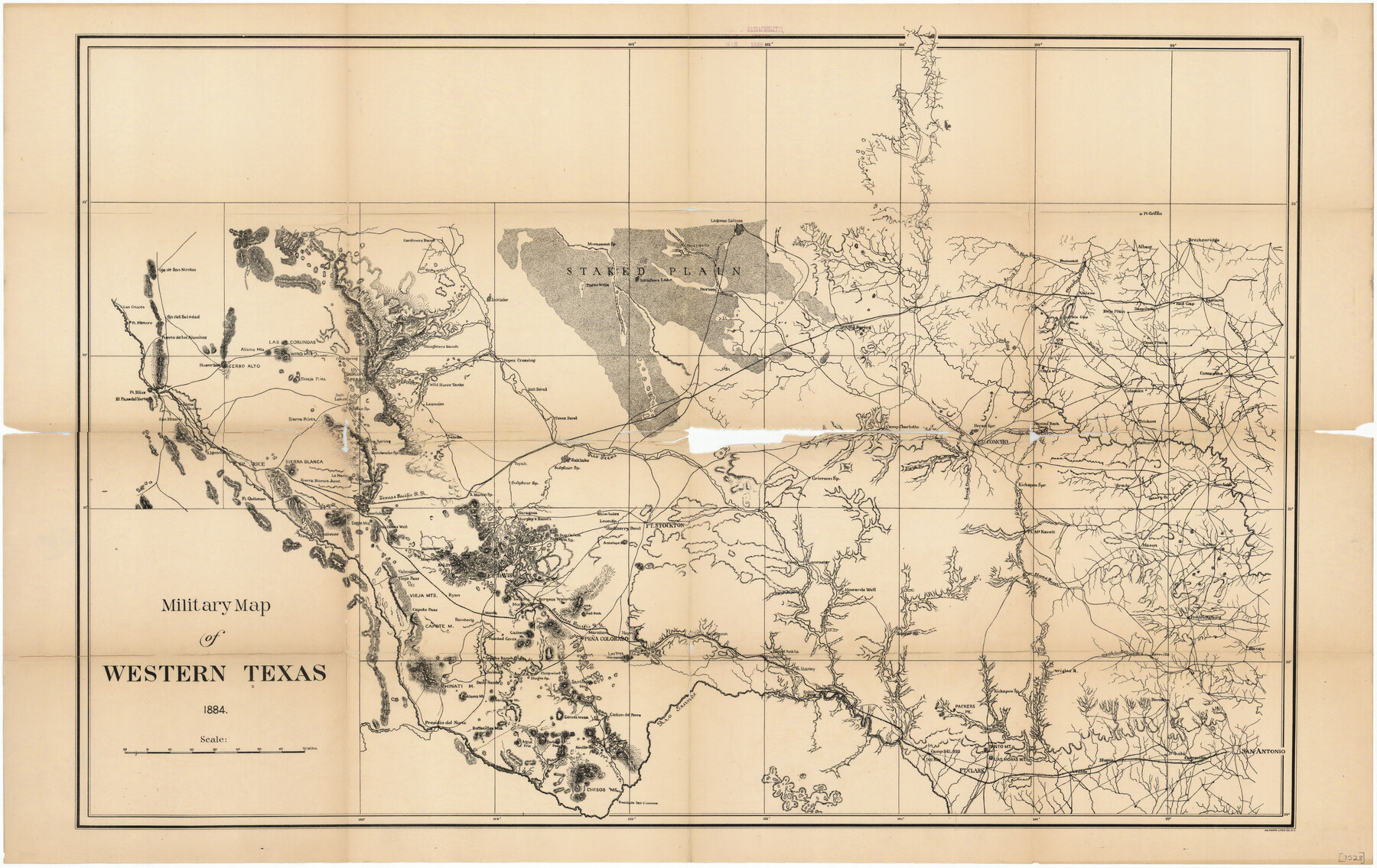
Military Map of Western Texas
-
Map/Doc
76315
-
Collection
Texas State Library and Archives
-
Object Dates
1884 (Creation Date)
-
Subjects
Military
-
Height x Width
24.1 x 38.2 inches
61.2 x 97.0 cm
-
Comments
Prints available courtesy of the Texas State Library and Archives.
More info can be found here: TSLAC Map 07528
Part of: Texas State Library and Archives
General Highway Map. Detail of Cities and Towns in Galveston County, Texas [Galveston and vicinity]
![79097, General Highway Map. Detail of Cities and Towns in Galveston County, Texas [Galveston and vicinity], Texas State Library and Archives](https://historictexasmaps.com/wmedia_w700/maps/79097.tif.jpg)
Print $20.00
General Highway Map. Detail of Cities and Towns in Galveston County, Texas [Galveston and vicinity]
1939
Size 18.4 x 25.0 inches
Map/Doc 79097
General Highway Map. Detail of Cities and Towns in Grimes County, Texas

Print $20.00
General Highway Map. Detail of Cities and Towns in Grimes County, Texas
1961
Size 18.2 x 24.8 inches
Map/Doc 79491
General Highway Map, Calhoun County, Texas

Print $20.00
General Highway Map, Calhoun County, Texas
1940
Size 18.5 x 25.3 inches
Map/Doc 79036
General Highway Map Supplementary Sheet Showing Detail of Cities and Towns in Bexar County Texas

Print $20.00
General Highway Map Supplementary Sheet Showing Detail of Cities and Towns in Bexar County Texas
1936
Size 18.5 x 25.0 inches
Map/Doc 76290
General Highway Map, Mills County, Texas

Print $20.00
General Highway Map, Mills County, Texas
1940
Size 18.4 x 24.8 inches
Map/Doc 79199
General Highway Map, Bell County, Texas

Print $20.00
General Highway Map, Bell County, Texas
1961
Size 18.3 x 25.1 inches
Map/Doc 79366
Map of the Republic of Texas and the Adjacent Territories, Indicating the Grants of Land Conceded under the Empresario System of Mexico

Print $20.00
Map of the Republic of Texas and the Adjacent Territories, Indicating the Grants of Land Conceded under the Empresario System of Mexico
1841
Size 13.4 x 16.7 inches
Map/Doc 76244
General Highway Map, Tom Green County, Texas

Print $20.00
General Highway Map, Tom Green County, Texas
1940
Size 25.0 x 18.5 inches
Map/Doc 79260
General Highway Map, Castro County, Texas

Print $20.00
General Highway Map, Castro County, Texas
1961
Size 18.2 x 24.7 inches
Map/Doc 79403
General Highway Map, Rusk County, Texas

Print $20.00
General Highway Map, Rusk County, Texas
1961
Size 24.9 x 18.2 inches
Map/Doc 79643
General Highway Map, Midland County, Texas

Print $20.00
General Highway Map, Midland County, Texas
1940
Size 18.2 x 24.5 inches
Map/Doc 79197
General Highway Map, Upshur County, Gregg County, Texas

Print $20.00
General Highway Map, Upshur County, Gregg County, Texas
1939
Size 24.9 x 18.6 inches
Map/Doc 79105
You may also like
[Galveston, Harrisburg & San Antonio Railroad from Cuero to Stockdale]
![64204, [Galveston, Harrisburg & San Antonio Railroad from Cuero to Stockdale], General Map Collection](https://historictexasmaps.com/wmedia_w700/maps/64204.tif.jpg)
Print $20.00
- Digital $50.00
[Galveston, Harrisburg & San Antonio Railroad from Cuero to Stockdale]
1907
Size 13.3 x 33.1 inches
Map/Doc 64204

San Patricio County NRC Article 33.136 Sketch 6

Print $24.00
- Digital $50.00
San Patricio County NRC Article 33.136 Sketch 6
2010
Size 22.0 x 34.0 inches
Map/Doc 94472
Flight Mission No. DQO-7K, Frame 98, Galveston County

Print $20.00
- Digital $50.00
Flight Mission No. DQO-7K, Frame 98, Galveston County
1952
Size 18.8 x 22.4 inches
Map/Doc 85113
Limestone County Working Sketch 12

Print $20.00
- Digital $50.00
Limestone County Working Sketch 12
1922
Size 18.5 x 12.8 inches
Map/Doc 70562
Nueces County Sketch File 13a

Print $12.00
- Digital $50.00
Nueces County Sketch File 13a
1889
Size 13.8 x 9.0 inches
Map/Doc 32539
[Hidalgo County]
![89517, [Hidalgo County], Barnes Railroad Collection](https://historictexasmaps.com/wmedia_w700/maps/89517.tif.jpg)
Print $20.00
- Digital $50.00
[Hidalgo County]
Size 44.7 x 26.0 inches
Map/Doc 89517
Sutton County Working Sketch 16

Print $40.00
- Digital $50.00
Sutton County Working Sketch 16
1972
Size 30.9 x 67.6 inches
Map/Doc 62359
The Chief Justice County of Sabine. Lands in Conflict with Jasper and San Augustine Counties

Print $20.00
The Chief Justice County of Sabine. Lands in Conflict with Jasper and San Augustine Counties
2020
Size 20.0 x 21.7 inches
Map/Doc 96069
A Traveler's Map of Spain and Portugal

A Traveler's Map of Spain and Portugal
Size 20.4 x 31.2 inches
Map/Doc 95929
Kendall County Boundary File 2b

Print $4.00
- Digital $50.00
Kendall County Boundary File 2b
Size 10.0 x 8.0 inches
Map/Doc 55754
Map of Padre Island Showing Location of Zoning Districts

Print $20.00
- Digital $50.00
Map of Padre Island Showing Location of Zoning Districts
1971
Size 26.2 x 18.5 inches
Map/Doc 4811