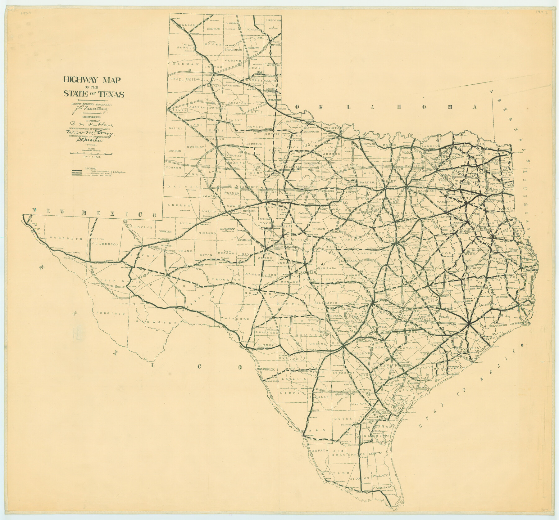
Highway Map of the State of Texas
-
Map/Doc
79309
-
Collection
Texas State Library and Archives
-
Object Dates
12/1/1922 (Creation Date)
-
People and Organizations
[Texas State Highway Department] (Publisher)
-
Subjects
State of Texas
-
Height x Width
34.0 x 36.5 inches
86.4 x 92.7 cm
-
Comments
Prints available courtesy of the Texas State Library and Archives.
More info can be found here: TSLAC Map 06184
Part of: Texas State Library and Archives
General Highway Map, San Saba County, Texas

Print $20.00
General Highway Map, San Saba County, Texas
1940
Size 18.3 x 24.8 inches
Map/Doc 79238
General Highway Map. Detail of Cities and Towns in Travis County, Texas. City Map, Austin and vicinity, Travis County, Texas

Print $20.00
General Highway Map. Detail of Cities and Towns in Travis County, Texas. City Map, Austin and vicinity, Travis County, Texas
1961
Size 18.2 x 25.0 inches
Map/Doc 79685
General Highway Map, Jim Wells County, Texas

Print $20.00
General Highway Map, Jim Wells County, Texas
1961
Size 18.1 x 24.7 inches
Map/Doc 79542
General Highway Map, Washington County, Texas

Print $20.00
General Highway Map, Washington County, Texas
1940
Size 18.4 x 25.0 inches
Map/Doc 79272
General Highway Map, Panola County, Texas

Print $20.00
General Highway Map, Panola County, Texas
1940
Size 18.2 x 24.6 inches
Map/Doc 79214
Railroad and County Map of Texas

Print $20.00
Railroad and County Map of Texas
1903
Size 33.5 x 37.4 inches
Map/Doc 76224
General Highway Map, El Paso County, Texas

Print $20.00
General Highway Map, El Paso County, Texas
1940
Size 18.4 x 24.7 inches
Map/Doc 79084
General Highway Map, Gonzales County, Texas

Print $20.00
General Highway Map, Gonzales County, Texas
1961
Size 18.2 x 24.7 inches
Map/Doc 79482
General Highway Map. Detail of Cities and Towns in Williamson County, Texas [Round Rock, Taylor, Georgetown]
![79714, General Highway Map. Detail of Cities and Towns in Williamson County, Texas [Round Rock, Taylor, Georgetown], Texas State Library and Archives](https://historictexasmaps.com/wmedia_w700/maps/79714.tif.jpg)
Print $20.00
General Highway Map. Detail of Cities and Towns in Williamson County, Texas [Round Rock, Taylor, Georgetown]
1961
Size 18.2 x 24.8 inches
Map/Doc 79714
General Highway Map. Detail of Cities and Towns in Bell County, Texas [Temple]
![79368, General Highway Map. Detail of Cities and Towns in Bell County, Texas [Temple], Texas State Library and Archives](https://historictexasmaps.com/wmedia_w700/maps/79368.tif.jpg)
Print $20.00
General Highway Map. Detail of Cities and Towns in Bell County, Texas [Temple]
1961
Size 18.2 x 25.0 inches
Map/Doc 79368
General Highway Map, Rusk County, Texas

Print $20.00
General Highway Map, Rusk County, Texas
1939
Size 24.7 x 18.2 inches
Map/Doc 79232
General Highway Map, Tom Green County, Texas

Print $20.00
General Highway Map, Tom Green County, Texas
1940
Size 25.0 x 18.5 inches
Map/Doc 79260
You may also like
Photo Index of Texas Coast - Sheet 2 of 6

Print $20.00
- Digital $50.00
Photo Index of Texas Coast - Sheet 2 of 6
1954
Size 20.0 x 24.0 inches
Map/Doc 83439
Colorado County Sketch File 18

Print $40.00
- Digital $50.00
Colorado County Sketch File 18
1897
Size 12.5 x 15.8 inches
Map/Doc 18950
Garza County Rolled Sketch 7

Print $11.00
- Digital $50.00
Garza County Rolled Sketch 7
1905
Size 10.0 x 15.4 inches
Map/Doc 45229
Henderson County Sketch File 10

Print $4.00
- Digital $50.00
Henderson County Sketch File 10
1859
Size 12.8 x 8.3 inches
Map/Doc 26346
[H. & G. N. RR. Co. Block 1]
![90889, [H. & G. N. RR. Co. Block 1], Twichell Survey Records](https://historictexasmaps.com/wmedia_w700/maps/90889-1.tif.jpg)
Print $20.00
- Digital $50.00
[H. & G. N. RR. Co. Block 1]
Size 16.5 x 27.9 inches
Map/Doc 90889
Pecos County Working Sketch 10
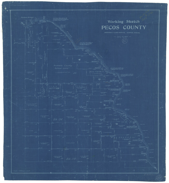
Print $20.00
- Digital $50.00
Pecos County Working Sketch 10
1907
Size 25.9 x 23.9 inches
Map/Doc 71480
Fisher County Working Sketch 5

Print $20.00
- Digital $50.00
Fisher County Working Sketch 5
1926
Size 23.0 x 25.6 inches
Map/Doc 69139
Drainage Basins of Texas Streams

Print $20.00
- Digital $50.00
Drainage Basins of Texas Streams
Size 35.3 x 42.0 inches
Map/Doc 65270
Bell County Working Sketch 2

Print $20.00
- Digital $50.00
Bell County Working Sketch 2
1938
Size 25.8 x 28.8 inches
Map/Doc 67342
Matagorda Bay and Approaches

Print $20.00
- Digital $50.00
Matagorda Bay and Approaches
1992
Size 36.6 x 44.6 inches
Map/Doc 73390
General Highway Map, Newton County, Texas

Print $20.00
General Highway Map, Newton County, Texas
1961
Size 19.3 x 25.0 inches
Map/Doc 79612
[Sketch showing Blocks B17-B29 and vicinity]
![89732, [Sketch showing Blocks B17-B29 and vicinity], Twichell Survey Records](https://historictexasmaps.com/wmedia_w700/maps/89732-1.tif.jpg)
Print $40.00
- Digital $50.00
[Sketch showing Blocks B17-B29 and vicinity]
Size 61.8 x 28.6 inches
Map/Doc 89732