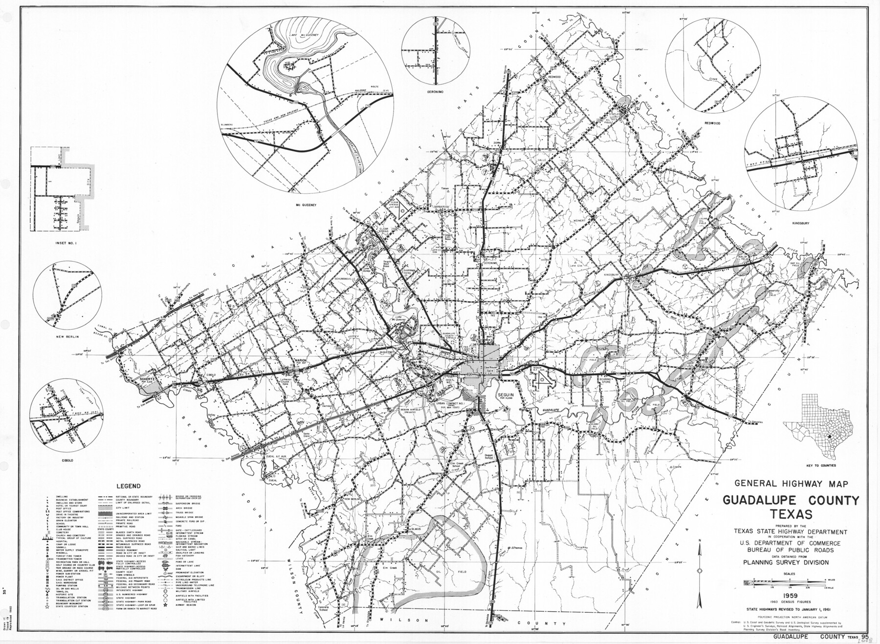
General Highway Map, Guadalupe County, Texas
-
Map/Doc
79492
-
Collection
Texas State Library and Archives
-
Object Dates
1961 (Creation Date)
-
People and Organizations
Texas State Highway Department (Publisher)
-
Counties
Guadalupe
-
Subjects
County
-
Height x Width
18.1 x 24.6 inches
46.0 x 62.5 cm
-
Comments
Prints available courtesy of the Texas State Library and Archives.
More info can be found here: TSLAC Map 05153
Part of: Texas State Library and Archives
General Highway Map, Nueces County, Texas

Print $20.00
General Highway Map, Nueces County, Texas
1940
Size 24.6 x 18.5 inches
Map/Doc 79209
Plan of the City of Austin

Print $20.00
Plan of the City of Austin
1853
Size 13.9 x 11.5 inches
Map/Doc 76207
General Highway Map, Franklin County, Morris County, Titus County, Camp County

Print $20.00
General Highway Map, Franklin County, Morris County, Titus County, Camp County
1940
Size 18.4 x 25.1 inches
Map/Doc 79040
General Highway Map. Detail of Cities and Towns in Bell County, Texas [Belton and Rogers and vicinity]
![79369, General Highway Map. Detail of Cities and Towns in Bell County, Texas [Belton and Rogers and vicinity], Texas State Library and Archives](https://historictexasmaps.com/wmedia_w700/maps/79369.tif.jpg)
Print $20.00
General Highway Map. Detail of Cities and Towns in Bell County, Texas [Belton and Rogers and vicinity]
1961
Size 25.0 x 18.3 inches
Map/Doc 79369
Greater Fort Worth New City Map

Print $20.00
Greater Fort Worth New City Map
1925
Size 33.5 x 22.6 inches
Map/Doc 76286
General Highway Map, Walker County, Texas

Print $20.00
General Highway Map, Walker County, Texas
1961
Size 24.7 x 18.1 inches
Map/Doc 79698
General Highway Map. Detail of Cities and Towns in Dallas County, Texas [Dallas and vicinity]
![79435, General Highway Map. Detail of Cities and Towns in Dallas County, Texas [Dallas and vicinity], Texas State Library and Archives](https://historictexasmaps.com/wmedia_w700/maps/79435.tif.jpg)
Print $20.00
General Highway Map. Detail of Cities and Towns in Dallas County, Texas [Dallas and vicinity]
1961
Size 18.2 x 24.6 inches
Map/Doc 79435
General Highway Map, Brooks County, Texas

Print $20.00
General Highway Map, Brooks County, Texas
1940
Size 18.5 x 25.0 inches
Map/Doc 79030
General Highway Map, Burnet County, Texas

Print $20.00
General Highway Map, Burnet County, Texas
1940
Size 18.6 x 25.2 inches
Map/Doc 79033
General Highway Map, Blanco County, Texas

Print $20.00
General Highway Map, Blanco County, Texas
1940
Size 25.0 x 18.5 inches
Map/Doc 79020
General Highway Map, McLennan County, Texas

Print $20.00
General Highway Map, McLennan County, Texas
1940
Size 18.3 x 24.6 inches
Map/Doc 79191
General Highway Map, Menard County, Texas

Print $20.00
General Highway Map, Menard County, Texas
1940
Size 18.5 x 24.8 inches
Map/Doc 79196
You may also like
Ward County Working Sketch 14

Print $20.00
- Digital $50.00
Ward County Working Sketch 14
1947
Size 30.3 x 28.8 inches
Map/Doc 72320
Index sheet to accompany map of survey for connecting the inland waters along margin of the Gulf of Mexico from Donaldsonville in Louisiana to the Rio Grande River in Texas

Print $20.00
- Digital $50.00
Index sheet to accompany map of survey for connecting the inland waters along margin of the Gulf of Mexico from Donaldsonville in Louisiana to the Rio Grande River in Texas
1874
Size 18.1 x 26.9 inches
Map/Doc 72694
Angelina County

Print $40.00
- Digital $50.00
Angelina County
1899
Size 38.9 x 49.9 inches
Map/Doc 4873
Cooke County Sketch File 46

Print $36.00
- Digital $50.00
Cooke County Sketch File 46
2002
Size 10.5 x 8.0 inches
Map/Doc 82578
Motley County Sketch File E1 (S)

Print $8.00
- Digital $50.00
Motley County Sketch File E1 (S)
Size 14.3 x 8.7 inches
Map/Doc 32175
Live Oak County Working Sketch 21

Print $20.00
- Digital $50.00
Live Oak County Working Sketch 21
1964
Size 30.8 x 33.9 inches
Map/Doc 70606
Map of Wise County

Print $20.00
- Digital $50.00
Map of Wise County
1895
Size 41.8 x 37.2 inches
Map/Doc 16932
Map Showing Part of the Blue Ridge Farm of the Texas Prison System, Fort Bend County, Texas

Print $20.00
- Digital $50.00
Map Showing Part of the Blue Ridge Farm of the Texas Prison System, Fort Bend County, Texas
Size 22.2 x 36.2 inches
Map/Doc 62979
Wilbarger County Sketch File 22

Print $4.00
- Digital $50.00
Wilbarger County Sketch File 22
1889
Size 9.7 x 6.2 inches
Map/Doc 40221
Flight Mission No. CGI-3N, Frame 159, Cameron County

Print $20.00
- Digital $50.00
Flight Mission No. CGI-3N, Frame 159, Cameron County
1954
Size 18.6 x 22.3 inches
Map/Doc 84623
Rio Grande, Madero Sheet

Print $20.00
- Digital $50.00
Rio Grande, Madero Sheet
1931
Size 33.0 x 38.5 inches
Map/Doc 65124
Crockett County Working Sketch 5

Print $40.00
- Digital $50.00
Crockett County Working Sketch 5
Size 12.3 x 62.5 inches
Map/Doc 68338