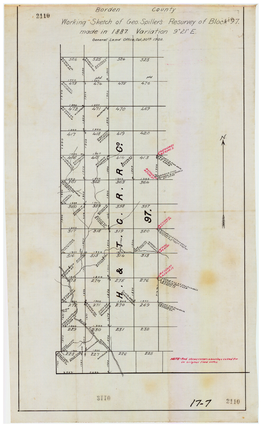
Borden County Working Sketch of Geo. Spiller's Resurvey of Block 97 made in 1887
17-7
-
Map/Doc
90211
-
Collection
Twichell Survey Records
-
Object Dates
10/30/1903 (Creation Date)
-
Counties
Borden
-
Subjects
Surveying Working Sketch
-
Height x Width
10.1 x 16.6 inches
25.7 x 42.2 cm
Part of: Twichell Survey Records
[Texas Boundary Line]
![92070, [Texas Boundary Line], Twichell Survey Records](https://historictexasmaps.com/wmedia_w700/maps/92070-1.tif.jpg)
Print $20.00
- Digital $50.00
[Texas Boundary Line]
Size 21.5 x 12.0 inches
Map/Doc 92070
[State Capitol Lands]
![91608, [State Capitol Lands], Twichell Survey Records](https://historictexasmaps.com/wmedia_w700/maps/91608-1.tif.jpg)
Print $20.00
- Digital $50.00
[State Capitol Lands]
1902
Size 28.2 x 32.8 inches
Map/Doc 91608
[Blocks O, H, B, S, RG, and 11]
![91333, [Blocks O, H, B, S, RG, and 11], Twichell Survey Records](https://historictexasmaps.com/wmedia_w700/maps/91333-1.tif.jpg)
Print $20.00
- Digital $50.00
[Blocks O, H, B, S, RG, and 11]
1921
Size 24.9 x 15.3 inches
Map/Doc 91333
This is a true copy of Peck's field book No. 7 pages 22 to 27, except classification of lands

Print $40.00
- Digital $50.00
This is a true copy of Peck's field book No. 7 pages 22 to 27, except classification of lands
Size 5.4 x 54.2 inches
Map/Doc 89726
Seagraves, Gaines County, Texas, Located in Surveys 10 and 15, Block C-34

Print $20.00
- Digital $50.00
Seagraves, Gaines County, Texas, Located in Surveys 10 and 15, Block C-34
Size 33.3 x 23.8 inches
Map/Doc 92687
John H. Stephens Block S2, State Capitol Leagues

Print $20.00
- Digital $50.00
John H. Stephens Block S2, State Capitol Leagues
Size 28.6 x 23.2 inches
Map/Doc 92995
Map of Capitol Syndicate Subdivisions of Capitol Land Reservation Leagues

Print $40.00
- Digital $50.00
Map of Capitol Syndicate Subdivisions of Capitol Land Reservation Leagues
1906
Size 44.6 x 72.6 inches
Map/Doc 93131
Working Sketch from Fisher County [around Roby]
![90911, Working Sketch from Fisher County [around Roby], Twichell Survey Records](https://historictexasmaps.com/wmedia_w700/maps/90911-1.tif.jpg)
Print $20.00
- Digital $50.00
Working Sketch from Fisher County [around Roby]
1901
Size 22.7 x 31.1 inches
Map/Doc 90911
[Yoakum and Gaines County Line Along Block D in Yoakum and Blocks A6, AX, C35 and C34 in Gaines]
![89691, [Yoakum and Gaines County Line Along Block D in Yoakum and Blocks A6, AX, C35 and C34 in Gaines], Twichell Survey Records](https://historictexasmaps.com/wmedia_w700/maps/89691-1.tif.jpg)
Print $40.00
- Digital $50.00
[Yoakum and Gaines County Line Along Block D in Yoakum and Blocks A6, AX, C35 and C34 in Gaines]
1924
Size 54.9 x 12.3 inches
Map/Doc 89691
[Central Part of County]
![89791, [Central Part of County], Twichell Survey Records](https://historictexasmaps.com/wmedia_w700/maps/89791-1.tif.jpg)
Print $40.00
- Digital $50.00
[Central Part of County]
Size 70.0 x 26.3 inches
Map/Doc 89791
[Map of Oldham County]
![91456, [Map of Oldham County], Twichell Survey Records](https://historictexasmaps.com/wmedia_w700/maps/91456-1.tif.jpg)
Print $20.00
- Digital $50.00
[Map of Oldham County]
Size 28.4 x 20.5 inches
Map/Doc 91456
[Sketch of sections 33 and 34]
![91575, [Sketch of sections 33 and 34], Twichell Survey Records](https://historictexasmaps.com/wmedia_w700/maps/91575-1.tif.jpg)
Print $2.00
- Digital $50.00
[Sketch of sections 33 and 34]
Size 5.0 x 8.7 inches
Map/Doc 91575
You may also like
Flight Mission No. DQN-7K, Frame 7, Calhoun County

Print $20.00
- Digital $50.00
Flight Mission No. DQN-7K, Frame 7, Calhoun County
1953
Size 18.5 x 22.2 inches
Map/Doc 84458
Map of San Patricio County

Print $20.00
- Digital $50.00
Map of San Patricio County
1863
Size 17.9 x 26.3 inches
Map/Doc 4018
San Jacinto County Working Sketch 33

Print $20.00
- Digital $50.00
San Jacinto County Working Sketch 33
1955
Size 25.4 x 31.8 inches
Map/Doc 63746
Houston County Working Sketch 11

Print $20.00
- Digital $50.00
Houston County Working Sketch 11
1953
Size 28.5 x 24.5 inches
Map/Doc 66241

Archer County Sketch File 22

Print $12.00
- Digital $50.00
Archer County Sketch File 22
1936
Size 11.1 x 8.6 inches
Map/Doc 13658
Map of Terry County

Print $20.00
- Digital $50.00
Map of Terry County
1901
Size 43.1 x 39.8 inches
Map/Doc 16892
Edwards County Sketch File 44

Print $4.00
- Digital $50.00
Edwards County Sketch File 44
1948
Size 11.4 x 8.9 inches
Map/Doc 21777
Hemphill County Sketch File 1

Print $40.00
- Digital $50.00
Hemphill County Sketch File 1
Size 17.1 x 13.9 inches
Map/Doc 26279
Map of Maverick County

Print $20.00
- Digital $50.00
Map of Maverick County
1875
Size 36.3 x 23.7 inches
Map/Doc 3849
Red River County Working Sketch 25

Print $20.00
- Digital $50.00
Red River County Working Sketch 25
1959
Size 23.0 x 22.2 inches
Map/Doc 72008
[Map of Chicago, Rock Island & Texas Railway through Tarrant County, Texas]
![64413, [Map of Chicago, Rock Island & Texas Railway through Tarrant County, Texas], General Map Collection](https://historictexasmaps.com/wmedia_w700/maps/64413.tif.jpg)
Print $40.00
- Digital $50.00
[Map of Chicago, Rock Island & Texas Railway through Tarrant County, Texas]
1893
Size 22.3 x 121.8 inches
Map/Doc 64413