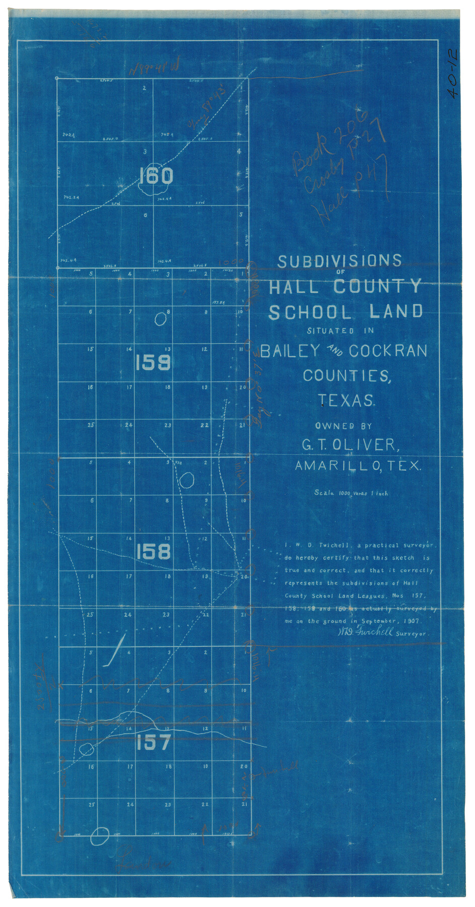
Subdivisions of Hall County School Land situated in Bailey and Cockran (sic) Counties, Texas owned by G. T. Oliver, Amarillo, Tex.
40-12
-
Map/Doc
90442
-
Collection
Twichell Survey Records
-
Object Dates
9/1907 (Creation Date)
-
People and Organizations
W.D. Twichell (Surveyor/Engineer)
-
Counties
Cochran
-
Height x Width
8.3 x 15.8 inches
21.1 x 40.1 cm
Part of: Twichell Survey Records
[River Secs. 68 1/2-73, Pt. Blk. GG]
![90478, [River Secs. 68 1/2-73, Pt. Blk. GG], Twichell Survey Records](https://historictexasmaps.com/wmedia_w700/maps/90478-1.tif.jpg)
Print $20.00
- Digital $50.00
[River Secs. 68 1/2-73, Pt. Blk. GG]
Size 27.6 x 20.7 inches
Map/Doc 90478
J. B. McCauley Irrigated Farm SW Quarter Section 20, Block E

Print $20.00
- Digital $50.00
J. B. McCauley Irrigated Farm SW Quarter Section 20, Block E
1944
Size 20.7 x 23.5 inches
Map/Doc 92335
Jim Nix Farm NW 1/4 Section 40, Block 1 Halsell Subdivision

Print $20.00
- Digital $50.00
Jim Nix Farm NW 1/4 Section 40, Block 1 Halsell Subdivision
Size 12.1 x 13.9 inches
Map/Doc 92400
Udell -V- Hughes Sketch

Print $20.00
- Digital $50.00
Udell -V- Hughes Sketch
Size 41.6 x 26.7 inches
Map/Doc 90894
[Blocks N and B]
![90498, [Blocks N and B], Twichell Survey Records](https://historictexasmaps.com/wmedia_w700/maps/90498-1.tif.jpg)
Print $3.00
- Digital $50.00
[Blocks N and B]
Size 10.0 x 11.4 inches
Map/Doc 90498
[Area Surrounding Lee County School Land]
![90887, [Area Surrounding Lee County School Land], Twichell Survey Records](https://historictexasmaps.com/wmedia_w700/maps/90887-1.tif.jpg)
Print $20.00
- Digital $50.00
[Area Surrounding Lee County School Land]
1907
Size 13.9 x 19.2 inches
Map/Doc 90887
Detail Sketch of A.B. Robertson's Ranch and J.W. James' Ranch situated in Garza and Crosby Counties, Texas

Print $40.00
- Digital $50.00
Detail Sketch of A.B. Robertson's Ranch and J.W. James' Ranch situated in Garza and Crosby Counties, Texas
Size 51.7 x 34.3 inches
Map/Doc 89754
Subdivision Map of Childress County School Land Situated in Bailey and Cochran Counties, Texas

Print $20.00
- Digital $50.00
Subdivision Map of Childress County School Land Situated in Bailey and Cochran Counties, Texas
Size 23.0 x 26.4 inches
Map/Doc 92526
Part of City of Plains

Print $20.00
- Digital $50.00
Part of City of Plains
Size 37.1 x 23.6 inches
Map/Doc 92449
[South Line of Block RG]
![91322, [South Line of Block RG], Twichell Survey Records](https://historictexasmaps.com/wmedia_w700/maps/91322-1.tif.jpg)
Print $20.00
- Digital $50.00
[South Line of Block RG]
Size 34.9 x 14.1 inches
Map/Doc 91322
[Blocks 3, 5 & Q]
![91275, [Blocks 3, 5 & Q], Twichell Survey Records](https://historictexasmaps.com/wmedia_w700/maps/91275-1.tif.jpg)
Print $20.00
- Digital $50.00
[Blocks 3, 5 & Q]
Size 19.4 x 9.2 inches
Map/Doc 91275
[H. & G. N. RR. Co. Block 1]
![90892, [H. & G. N. RR. Co. Block 1], Twichell Survey Records](https://historictexasmaps.com/wmedia_w700/maps/90892-1.tif.jpg)
Print $20.00
- Digital $50.00
[H. & G. N. RR. Co. Block 1]
1902
Size 14.9 x 15.8 inches
Map/Doc 90892
You may also like
San Augustine and Sabine Counties

Print $20.00
- Digital $50.00
San Augustine and Sabine Counties
1881
Size 23.7 x 26.3 inches
Map/Doc 4012
[Surveys on the waters of Pine Creeke of the Neches]
![348, [Surveys on the waters of Pine Creeke of the Neches], General Map Collection](https://historictexasmaps.com/wmedia_w700/maps/348.tif.jpg)
Print $2.00
- Digital $50.00
[Surveys on the waters of Pine Creeke of the Neches]
1845
Size 7.9 x 8.2 inches
Map/Doc 348
Floyd County Sketch File 18

Print $32.00
- Digital $50.00
Floyd County Sketch File 18
1913
Size 13.4 x 9.0 inches
Map/Doc 22753
Surveys of Hutchins Stock Assn. Lse.

Print $20.00
- Digital $50.00
Surveys of Hutchins Stock Assn. Lse.
1929
Size 41.3 x 21.1 inches
Map/Doc 92817
Freestone County Rolled Sketch 13A

Print $20.00
- Digital $50.00
Freestone County Rolled Sketch 13A
1990
Size 45.2 x 33.7 inches
Map/Doc 5914
Ward County Rolled Sketch L-1

Print $20.00
- Digital $50.00
Ward County Rolled Sketch L-1
Size 24.1 x 43.4 inches
Map/Doc 8168
Henderson County Sketch File 5

Print $4.00
- Digital $50.00
Henderson County Sketch File 5
1853
Size 12.9 x 8.2 inches
Map/Doc 26325
Lovington Lea County, New Mexico

Print $20.00
- Digital $50.00
Lovington Lea County, New Mexico
Size 19.3 x 31.6 inches
Map/Doc 92419
Jones County Sketch File 15

Print $40.00
- Digital $50.00
Jones County Sketch File 15
1892
Size 13.7 x 16.3 inches
Map/Doc 28503
Cameron County Aerial Photograph Index Sheet 4

Print $20.00
- Digital $50.00
Cameron County Aerial Photograph Index Sheet 4
1955
Size 19.3 x 17.4 inches
Map/Doc 83676
Rusk County Working Sketch 32

Print $20.00
- Digital $50.00
Rusk County Working Sketch 32
1919
Size 16.7 x 17.1 inches
Map/Doc 63669
The Judicial District/County of Pashcal. Abolished, Spring 1842

Print $20.00
The Judicial District/County of Pashcal. Abolished, Spring 1842
2020
Size 15.0 x 21.7 inches
Map/Doc 96345