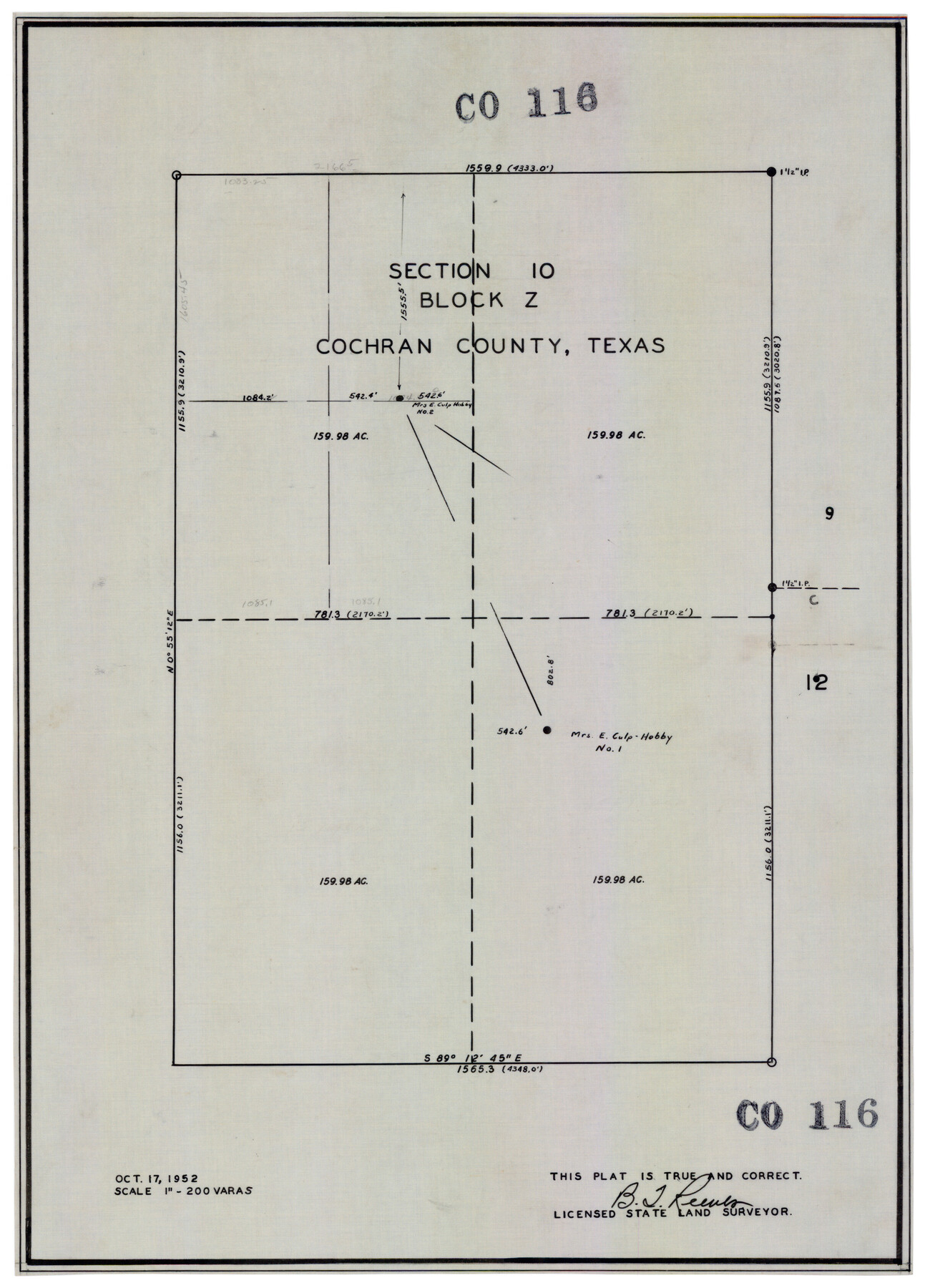
Section 10, Block Z, Cochran County, Texas
CO116
-
Map/Doc
92521
-
Collection
Twichell Survey Records
-
Object Dates
10/17/1952 (Creation Date)
-
People and Organizations
B.T. Reeves (Surveyor/Engineer)
-
Counties
Cochran
-
Height x Width
12.2 x 17.0 inches
31.0 x 43.2 cm
Part of: Twichell Survey Records
[Blocks 34-36, Township 1N]
![92031, [Blocks 34-36, Township 1N], Twichell Survey Records](https://historictexasmaps.com/wmedia_w700/maps/92031-1.tif.jpg)
Print $20.00
- Digital $50.00
[Blocks 34-36, Township 1N]
Size 36.8 x 23.8 inches
Map/Doc 92031
Plat of Common Line of Baylor and Throckmorton Counties as Run by A.D. Kerr and F.B. Stribling

Print $40.00
- Digital $50.00
Plat of Common Line of Baylor and Throckmorton Counties as Run by A.D. Kerr and F.B. Stribling
Size 63.0 x 9.0 inches
Map/Doc 89640
Dallam County

Print $20.00
- Digital $50.00
Dallam County
1888
Size 29.5 x 24.6 inches
Map/Doc 90654
University of Texas System University Lands

Print $20.00
- Digital $50.00
University of Texas System University Lands
Size 17.7 x 23.2 inches
Map/Doc 93242
Revised Sectional Map Number 2, Lands in Texas and Pacific Railway Reservation From Westbrook Station in Mitchell County to Metz Station in Ector County

Print $20.00
- Digital $50.00
Revised Sectional Map Number 2, Lands in Texas and Pacific Railway Reservation From Westbrook Station in Mitchell County to Metz Station in Ector County
Size 25.1 x 19.6 inches
Map/Doc 91366
[Block O1, Godair]
![90565, [Block O1, Godair], Twichell Survey Records](https://historictexasmaps.com/wmedia_w700/maps/90565-1.tif.jpg)
Print $20.00
- Digital $50.00
[Block O1, Godair]
Size 22.6 x 17.7 inches
Map/Doc 90565
[Blocks O, N, 34, B19, B29]
![92969, [Blocks O, N, 34, B19, B29], Twichell Survey Records](https://historictexasmaps.com/wmedia_w700/maps/92969-1.tif.jpg)
Print $20.00
- Digital $50.00
[Blocks O, N, 34, B19, B29]
Size 24.1 x 24.4 inches
Map/Doc 92969
C. A. Pierce's Subdivision of Dick Slaughter Land

Print $20.00
- Digital $50.00
C. A. Pierce's Subdivision of Dick Slaughter Land
Size 37.7 x 17.1 inches
Map/Doc 90301
Utility Map, Low Rent Housing Project Texas 18-1, Housing Authority of the City of Lubbock (Plan No. 3)

Print $20.00
- Digital $50.00
Utility Map, Low Rent Housing Project Texas 18-1, Housing Authority of the City of Lubbock (Plan No. 3)
1941
Size 42.5 x 27.3 inches
Map/Doc 92758
Culberson County

Print $40.00
- Digital $50.00
Culberson County
1924
Size 32.4 x 48.5 inches
Map/Doc 92559
Revised Sectional Map No. 4 Showing Land Surveys in the Western Portion of the County of El Paso, Texas

Print $20.00
- Digital $50.00
Revised Sectional Map No. 4 Showing Land Surveys in the Western Portion of the County of El Paso, Texas
Size 24.7 x 19.7 inches
Map/Doc 93226
University Place - Addition

Print $20.00
- Digital $50.00
University Place - Addition
Size 20.2 x 12.0 inches
Map/Doc 92411
You may also like
Plat Section 2, Block B-16

Print $20.00
- Digital $50.00
Plat Section 2, Block B-16
1930
Size 19.0 x 9.8 inches
Map/Doc 90802
Schleicher County Rolled Sketch 11

Print $20.00
- Digital $50.00
Schleicher County Rolled Sketch 11
1951
Size 24.9 x 19.2 inches
Map/Doc 7754
Topographical Map of the Rio Grande, Sheet No. 8

Print $20.00
- Digital $50.00
Topographical Map of the Rio Grande, Sheet No. 8
1912
Map/Doc 89532
Castro County Rolled Sketch 14

Print $20.00
- Digital $50.00
Castro County Rolled Sketch 14
1965
Size 47.6 x 43.5 inches
Map/Doc 8608
Map of Wilbarger County Young Land District formerly Fannin Land District

Print $20.00
- Digital $50.00
Map of Wilbarger County Young Land District formerly Fannin Land District
1859
Size 22.7 x 20.6 inches
Map/Doc 4146
Wise County Rolled Sketch 1

Print $40.00
- Digital $50.00
Wise County Rolled Sketch 1
1941
Size 40.6 x 52.8 inches
Map/Doc 10154
Shackelford County Boundary File 7a

Print $9.00
- Digital $50.00
Shackelford County Boundary File 7a
Size 14.9 x 9.4 inches
Map/Doc 58689
Jeff Davis County Working Sketch 37

Print $20.00
- Digital $50.00
Jeff Davis County Working Sketch 37
1979
Size 31.6 x 36.6 inches
Map/Doc 66532
Flight Mission No. BRA-6M, Frame 96, Jefferson County

Print $20.00
- Digital $50.00
Flight Mission No. BRA-6M, Frame 96, Jefferson County
1953
Size 18.5 x 22.3 inches
Map/Doc 85439
Flight Mission No. DQN-2K, Frame 119, Calhoun County

Print $20.00
- Digital $50.00
Flight Mission No. DQN-2K, Frame 119, Calhoun County
1953
Size 16.8 x 16.5 inches
Map/Doc 84295
Garza County Sketch File 26

Print $4.00
- Digital $50.00
Garza County Sketch File 26
Size 10.9 x 8.5 inches
Map/Doc 24095
