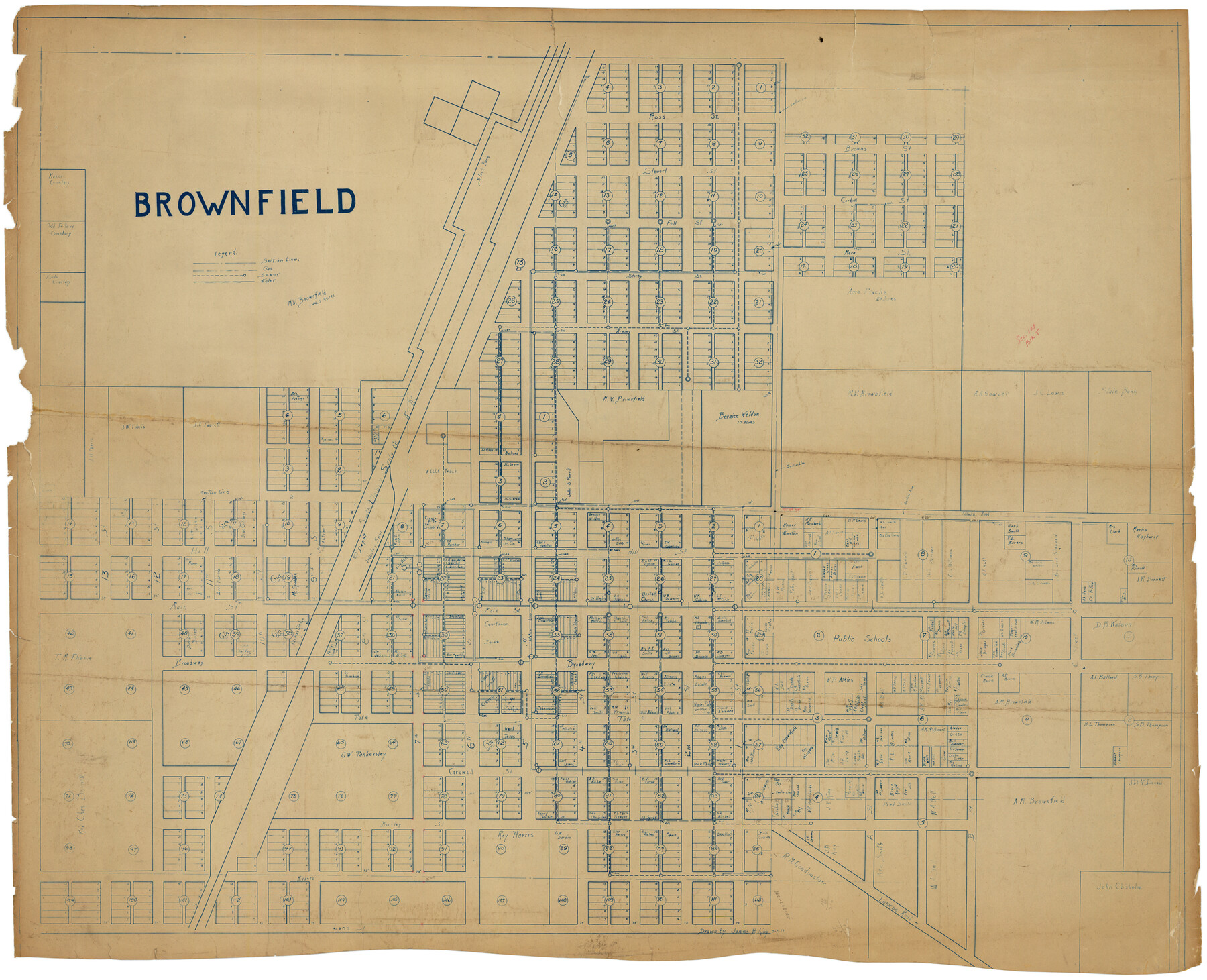
Brownfield
-
Map/Doc
92936
-
Collection
Twichell Survey Records
-
Counties
Terry
-
Height x Width
42.8 x 34.8 inches
108.7 x 88.4 cm
Part of: Twichell Survey Records
[Block O1, Godair]
![90566, [Block O1, Godair], Twichell Survey Records](https://historictexasmaps.com/wmedia_w700/maps/90566-1.tif.jpg)
Print $20.00
- Digital $50.00
[Block O1, Godair]
Size 22.7 x 18.0 inches
Map/Doc 90566
Working Sketch of Moore County

Print $20.00
- Digital $50.00
Working Sketch of Moore County
Size 27.7 x 15.6 inches
Map/Doc 93002
[Capitol Leagues along New Mexico Line]
![90766, [Capitol Leagues along New Mexico Line], Twichell Survey Records](https://historictexasmaps.com/wmedia_w700/maps/90766-1.tif.jpg)
Print $20.00
- Digital $50.00
[Capitol Leagues along New Mexico Line]
Size 8.2 x 22.7 inches
Map/Doc 90766
[Capitol Land Leagues and Blocks M6, 10T, T1, O5 and part of Block B]
![93194, [Capitol Land Leagues and Blocks M6, 10T, T1, O5 and part of Block B], Twichell Survey Records](https://historictexasmaps.com/wmedia_w700/maps/93194-1.tif.jpg)
Print $40.00
- Digital $50.00
[Capitol Land Leagues and Blocks M6, 10T, T1, O5 and part of Block B]
Size 43.7 x 105.6 inches
Map/Doc 93194
[H. & G. N. Block 4]
![90268, [H. & G. N. Block 4], Twichell Survey Records](https://historictexasmaps.com/wmedia_w700/maps/90268-1.tif.jpg)
Print $20.00
- Digital $50.00
[H. & G. N. Block 4]
1887
Size 22.2 x 19.6 inches
Map/Doc 90268
Leagues 218, 220, 238- 241, 226- 229]
![91066, Leagues 218, 220, 238- 241, 226- 229], Twichell Survey Records](https://historictexasmaps.com/wmedia_w700/maps/91066-1.tif.jpg)
Print $20.00
- Digital $50.00
Leagues 218, 220, 238- 241, 226- 229]
Size 10.3 x 33.7 inches
Map/Doc 91066
[Blocks M25, M22, R, and vicinity]
![91240, [Blocks M25, M22, R, and vicinity], Twichell Survey Records](https://historictexasmaps.com/wmedia_w700/maps/91240-1.tif.jpg)
Print $20.00
- Digital $50.00
[Blocks M25, M22, R, and vicinity]
1922
Size 29.0 x 25.7 inches
Map/Doc 91240
Sketch in Hockley County

Print $20.00
- Digital $50.00
Sketch in Hockley County
1911
Size 7.1 x 20.5 inches
Map/Doc 91123
Parkland Place

Print $20.00
- Digital $50.00
Parkland Place
1928
Size 15.9 x 13.0 inches
Map/Doc 92278
[Southeast Portion of Lubbock County]
![91313, [Southeast Portion of Lubbock County], Twichell Survey Records](https://historictexasmaps.com/wmedia_w700/maps/91313-1.tif.jpg)
Print $20.00
- Digital $50.00
[Southeast Portion of Lubbock County]
Size 24.7 x 18.5 inches
Map/Doc 91313
[H. & T. C. Block 47, Sections 47- 55 Corrections]
![91529, [H. & T. C. Block 47, Sections 47- 55 Corrections], Twichell Survey Records](https://historictexasmaps.com/wmedia_w700/maps/91529-1.tif.jpg)
Print $3.00
- Digital $50.00
[H. & T. C. Block 47, Sections 47- 55 Corrections]
Size 11.6 x 13.3 inches
Map/Doc 91529
Garden of Peace, Section C, Lawnhaven Memorial Park

Print $20.00
- Digital $50.00
Garden of Peace, Section C, Lawnhaven Memorial Park
Size 26.9 x 18.8 inches
Map/Doc 92119
You may also like
Kimble County Working Sketch 10

Print $20.00
- Digital $50.00
Kimble County Working Sketch 10
1921
Size 14.7 x 15.5 inches
Map/Doc 70078
San Patricio County Rolled Sketch 34

Print $20.00
- Digital $50.00
San Patricio County Rolled Sketch 34
Size 25.8 x 26.2 inches
Map/Doc 7584

Goliad County Sketch File 13

Print $8.00
- Digital $50.00
Goliad County Sketch File 13
1856
Size 12.4 x 8.0 inches
Map/Doc 24239
Map of the Straits of Florida and Gulf of Mexico

Print $20.00
- Digital $50.00
Map of the Straits of Florida and Gulf of Mexico
1851
Size 18.4 x 27.5 inches
Map/Doc 72674
Flight Mission No. CLL-1N, Frame 37, Willacy County

Print $20.00
- Digital $50.00
Flight Mission No. CLL-1N, Frame 37, Willacy County
1954
Size 18.4 x 22.0 inches
Map/Doc 87018
Pecos County Working Sketch 17

Print $20.00
- Digital $50.00
Pecos County Working Sketch 17
1915
Size 32.5 x 23.0 inches
Map/Doc 71487
Fort Bend County Boundary File 2

Print $8.00
- Digital $50.00
Fort Bend County Boundary File 2
Size 14.3 x 8.9 inches
Map/Doc 53559
Red River County Rolled Sketch 4

Print $20.00
- Digital $50.00
Red River County Rolled Sketch 4
Size 37.3 x 32.2 inches
Map/Doc 9841
Terrell County Working Sketch 35

Print $20.00
- Digital $50.00
Terrell County Working Sketch 35
1948
Size 38.4 x 42.2 inches
Map/Doc 62127
Val Verde County Working Sketch 88

Print $20.00
- Digital $50.00
Val Verde County Working Sketch 88
1973
Size 29.0 x 36.9 inches
Map/Doc 72223
General Highway Map. Detail of Cities and Towns in Nacogdoches County, Texas

Print $20.00
General Highway Map. Detail of Cities and Towns in Nacogdoches County, Texas
1961
Size 19.3 x 25.0 inches
Map/Doc 79608