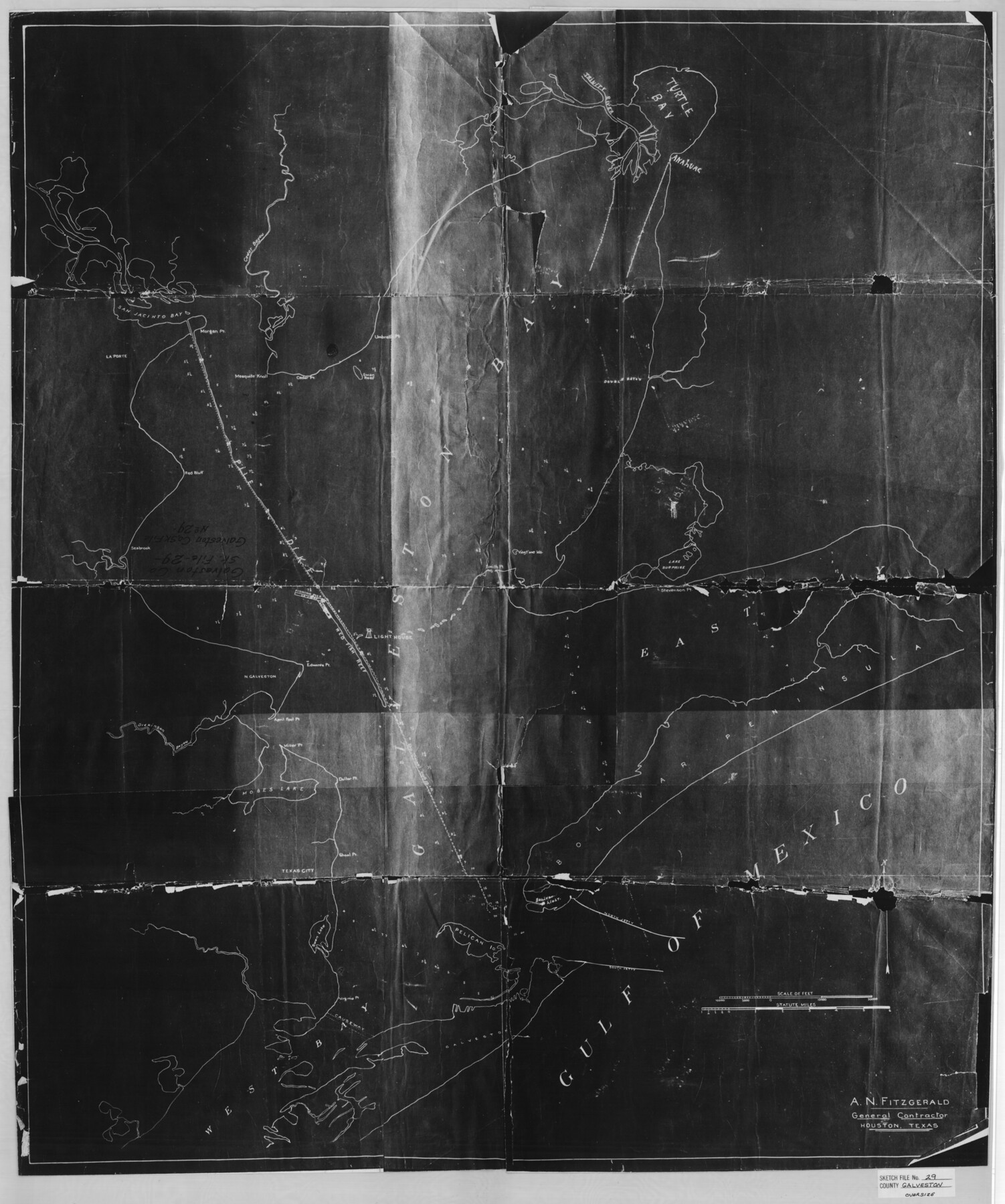
Galveston County Sketch File 29
[Maps of Galveston Bay]
-
Map/Doc
10454
-
Collection
General Map Collection
-
People and Organizations
A.N. Fitzgerald (Draftsman)
-
Counties
Galveston Chambers Harris
-
Subjects
Surveying Sketch File
-
Height x Width
35.1 x 29.3 inches
89.2 x 74.4 cm
-
Medium
multi-page, multi-format
-
Features
Bolivar Peninsula
Fishing Pier
Red Fish Reef
N. Galveston
Dickinson Bayou
Miller Point
April Fool Point
Dollar Point
Stevenson Point
Gulf of Mexico
Seabrook
Bolivar Light
North Jetty
Moses Lake
Shoal Point
Texas City
South Jetty
West Bay
Causeway
Galveston Island
Galveston Bay
Turtle Bay
Anahuac
Umbrella Point
Cedar Bayou
Swan Reef
Morgan Point
San Jacinto Bay
La Porte
Mesquite Knoll
Trinity River
Double Bayou
East Bay
Lake Surprise
Vingt'une Islands
Smith Point
Light House
Pile Dike
Red Bluff
Part of: General Map Collection
United States - Gulf Coast Texas - Southern part of Laguna Madre

Print $20.00
- Digital $50.00
United States - Gulf Coast Texas - Southern part of Laguna Madre
1941
Size 18.2 x 27.7 inches
Map/Doc 72947
Grayson County Boundary File 5

Print $4.00
- Digital $50.00
Grayson County Boundary File 5
Size 11.2 x 8.7 inches
Map/Doc 53959
Live Oak County Working Sketch 33

Print $20.00
- Digital $50.00
Live Oak County Working Sketch 33
1992
Size 25.9 x 35.1 inches
Map/Doc 70618

Concho County Boundary File 4

Print $2.00
- Digital $50.00
Concho County Boundary File 4
Size 12.7 x 8.4 inches
Map/Doc 51825
Hidalgo County Rolled Sketch 15

Print $40.00
- Digital $50.00
Hidalgo County Rolled Sketch 15
1963
Size 68.9 x 41.9 inches
Map/Doc 9170
Hardeman County

Print $20.00
- Digital $50.00
Hardeman County
1935
Size 44.4 x 41.4 inches
Map/Doc 73170
Duval County Working Sketch 47

Print $20.00
- Digital $50.00
Duval County Working Sketch 47
1981
Size 20.8 x 30.9 inches
Map/Doc 68771
Flight Mission No. CLL-1N, Frame 186, Willacy County

Print $20.00
- Digital $50.00
Flight Mission No. CLL-1N, Frame 186, Willacy County
1954
Size 18.4 x 22.1 inches
Map/Doc 87056
Terrell County Sketch File 28

Print $20.00
- Digital $50.00
Terrell County Sketch File 28
1939
Size 18.3 x 22.8 inches
Map/Doc 12425
Ward County Working Sketch 5

Print $20.00
- Digital $50.00
Ward County Working Sketch 5
1943
Size 19.1 x 36.5 inches
Map/Doc 72311
Upton County Working Sketch 44

Print $20.00
- Digital $50.00
Upton County Working Sketch 44
1962
Size 19.2 x 25.5 inches
Map/Doc 69540
You may also like
Flight Mission No. DQO-8K, Frame 6, Galveston County

Print $20.00
- Digital $50.00
Flight Mission No. DQO-8K, Frame 6, Galveston County
1952
Size 18.8 x 22.3 inches
Map/Doc 85129
Supreme Court of the United States October Term, 1926, No. 6, Original - State of Oklahoma, Complainant vs. The State of Texas, Defendant, the United States, Intervener; Fourth Report of the Boundary Commissioners

Print $482.00
- Digital $50.00
Supreme Court of the United States October Term, 1926, No. 6, Original - State of Oklahoma, Complainant vs. The State of Texas, Defendant, the United States, Intervener; Fourth Report of the Boundary Commissioners
1927
Size 6.0 x 9.2 inches
Map/Doc 3060
Flight Mission No. CRE-1R, Frame 194, Jackson County

Print $20.00
- Digital $50.00
Flight Mission No. CRE-1R, Frame 194, Jackson County
1956
Size 18.5 x 22.3 inches
Map/Doc 85348
Map of the County of Cameron

Print $40.00
- Digital $50.00
Map of the County of Cameron
1884
Size 59.4 x 35.8 inches
Map/Doc 76058
Intracoastal Waterway, Houma, LA to Corpus Christi, TX

Print $20.00
- Digital $50.00
Intracoastal Waterway, Houma, LA to Corpus Christi, TX
Size 18.9 x 27.9 inches
Map/Doc 61906
Bauer & Cockrell Lands Located in Martin County, Texas

Print $20.00
- Digital $50.00
Bauer & Cockrell Lands Located in Martin County, Texas
1908
Size 28.5 x 22.3 inches
Map/Doc 91365
Brewster County Working Sketch 13

Print $20.00
- Digital $50.00
Brewster County Working Sketch 13
1928
Size 39.5 x 43.9 inches
Map/Doc 67546
Texas & Pacific Ry Reserve west of the Pecos River

Print $40.00
- Digital $50.00
Texas & Pacific Ry Reserve west of the Pecos River
1880
Size 43.9 x 90.6 inches
Map/Doc 3047
Flight Mission No. DQN-5K, Frame 148, Calhoun County

Print $20.00
- Digital $50.00
Flight Mission No. DQN-5K, Frame 148, Calhoun County
1953
Size 18.6 x 21.9 inches
Map/Doc 84423
Collin County Sketch File 1

Print $6.00
- Digital $50.00
Collin County Sketch File 1
1853
Size 6.4 x 8.2 inches
Map/Doc 18855
Old Miscellaneous File 27c

Print $18.00
- Digital $50.00
Old Miscellaneous File 27c
1880
Size 14.1 x 8.6 inches
Map/Doc 75727
Hardin County Rolled Sketch 22

Print $20.00
- Digital $50.00
Hardin County Rolled Sketch 22
1977
Size 32.0 x 44.4 inches
Map/Doc 9110