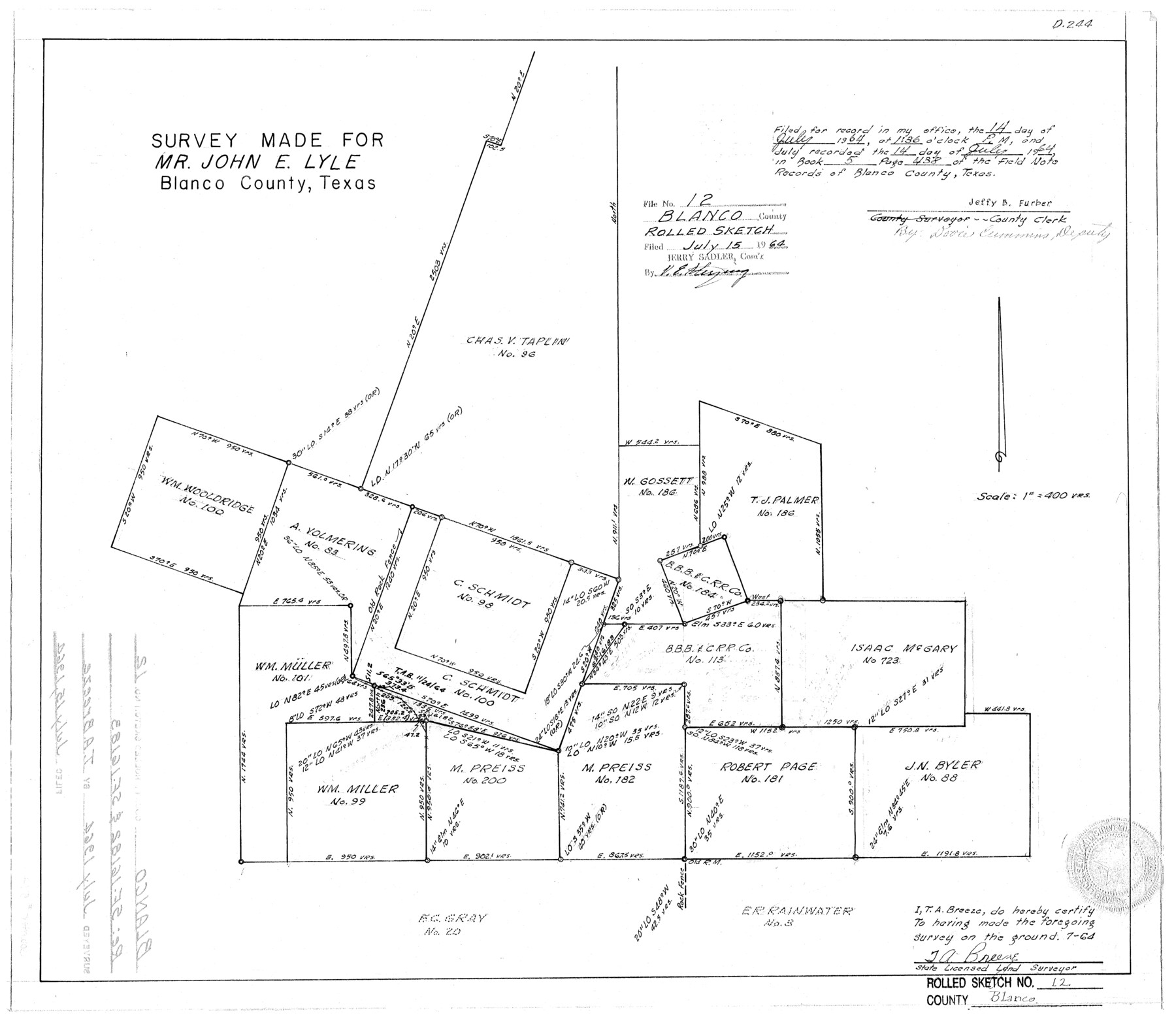
Blanco County Rolled Sketch 12
Survey made for Mr. John E. Lyle [regarding SF-16182 and SF-16183]
-
Map/Doc
5148
-
Collection
General Map Collection
-
Object Dates
1964 (Creation Date)
1964/7/15 (File Date)
-
People and Organizations
T.A. Breeze (Surveyor/Engineer)
Jeffy B. Furber (County/Other Clerk)
-
Counties
Blanco
-
Subjects
Surveying Rolled Sketch
-
Height x Width
17.3 x 20.0 inches
43.9 x 50.8 cm
-
Scale
1" = 400 varas
Part of: General Map Collection
Hardin County Sketch File 53

Print $12.00
- Digital $50.00
Hardin County Sketch File 53
Size 11.4 x 8.8 inches
Map/Doc 25213
Cass County Sketch File 18

Print $4.00
- Digital $50.00
Cass County Sketch File 18
Size 7.4 x 10.3 inches
Map/Doc 17420
Frio County Working Sketch 12

Print $40.00
- Digital $50.00
Frio County Working Sketch 12
1953
Size 52.8 x 39.9 inches
Map/Doc 69286

Motley County

Print $20.00
- Digital $50.00
Motley County
1914
Size 47.7 x 37.4 inches
Map/Doc 10797
Edwards County Rolled Sketch J

Print $83.00
- Digital $50.00
Edwards County Rolled Sketch J
1918
Size 23.6 x 30.3 inches
Map/Doc 5818
Navigation Maps of Gulf Intracoastal Waterway, Port Arthur to Brownsville, Texas

Print $4.00
- Digital $50.00
Navigation Maps of Gulf Intracoastal Waterway, Port Arthur to Brownsville, Texas
1951
Size 16.7 x 21.3 inches
Map/Doc 65444
Jeff Davis County Working Sketch 21

Print $20.00
- Digital $50.00
Jeff Davis County Working Sketch 21
1957
Size 25.2 x 44.0 inches
Map/Doc 66516
Jim Hogg County Rolled Sketch 6

Print $40.00
- Digital $50.00
Jim Hogg County Rolled Sketch 6
1943
Size 51.9 x 38.4 inches
Map/Doc 9322
Atascosa County Rolled Sketch 22

Print $40.00
- Digital $50.00
Atascosa County Rolled Sketch 22
1917
Size 26.3 x 57.2 inches
Map/Doc 8434
Brazos Island Harbor, Texas - Dredging Entrance Channel Plan

Print $20.00
- Digital $50.00
Brazos Island Harbor, Texas - Dredging Entrance Channel Plan
1990
Size 14.5 x 20.1 inches
Map/Doc 83338
Cochran County Boundary File 3a

Print $34.00
- Digital $50.00
Cochran County Boundary File 3a
Size 11.2 x 8.8 inches
Map/Doc 51538
You may also like
[Notes and rough sketch of survey 6, Block 16 and survey 19 1/2, Block 19]
![93053, [Notes and rough sketch of survey 6, Block 16 and survey 19 1/2, Block 19], Twichell Survey Records](https://historictexasmaps.com/wmedia_w700/maps/93053-1.tif.jpg)
Print $20.00
- Digital $50.00
[Notes and rough sketch of survey 6, Block 16 and survey 19 1/2, Block 19]
Size 23.8 x 11.8 inches
Map/Doc 93053
Acts of the Visit of the Royal Commissioners (sometimes referred to as the “Visita General”) - Camargo

Acts of the Visit of the Royal Commissioners (sometimes referred to as the “Visita General”) - Camargo
1767
Size 14.3 x 9.5 inches
Map/Doc 94254
Loving County Working Sketch 9

Print $20.00
- Digital $50.00
Loving County Working Sketch 9
1952
Size 24.8 x 45.8 inches
Map/Doc 70641
Parker County Sketch File 42

Print $114.00
- Digital $50.00
Parker County Sketch File 42
1877
Size 14.4 x 12.0 inches
Map/Doc 33589
University of Texas System University Lands

Print $20.00
- Digital $50.00
University of Texas System University Lands
1938
Size 17.9 x 23.5 inches
Map/Doc 93249
Flight Mission No. BRA-3M, Frame 129, Jefferson County

Print $20.00
- Digital $50.00
Flight Mission No. BRA-3M, Frame 129, Jefferson County
1953
Size 18.5 x 22.3 inches
Map/Doc 85403
Matagorda County Sketch File 15

Print $48.00
- Digital $50.00
Matagorda County Sketch File 15
Size 8.7 x 11.2 inches
Map/Doc 30774
Menard County Working Sketch 20

Print $20.00
- Digital $50.00
Menard County Working Sketch 20
1947
Size 38.5 x 34.9 inches
Map/Doc 70967
Aransas County NRC Article 33.136 Location Key Sheet

Print $20.00
- Digital $50.00
Aransas County NRC Article 33.136 Location Key Sheet
1979
Size 27.0 x 23.0 inches
Map/Doc 77006
Map of Maverick County

Print $20.00
- Digital $50.00
Map of Maverick County
1875
Size 36.3 x 23.7 inches
Map/Doc 3849
Roberts County Boundary File 1

Print $40.00
- Digital $50.00
Roberts County Boundary File 1
Size 14.4 x 8.9 inches
Map/Doc 58313
Young County Sketch File 22

Print $20.00
- Digital $50.00
Young County Sketch File 22
1957
Size 22.9 x 19.8 inches
Map/Doc 12716