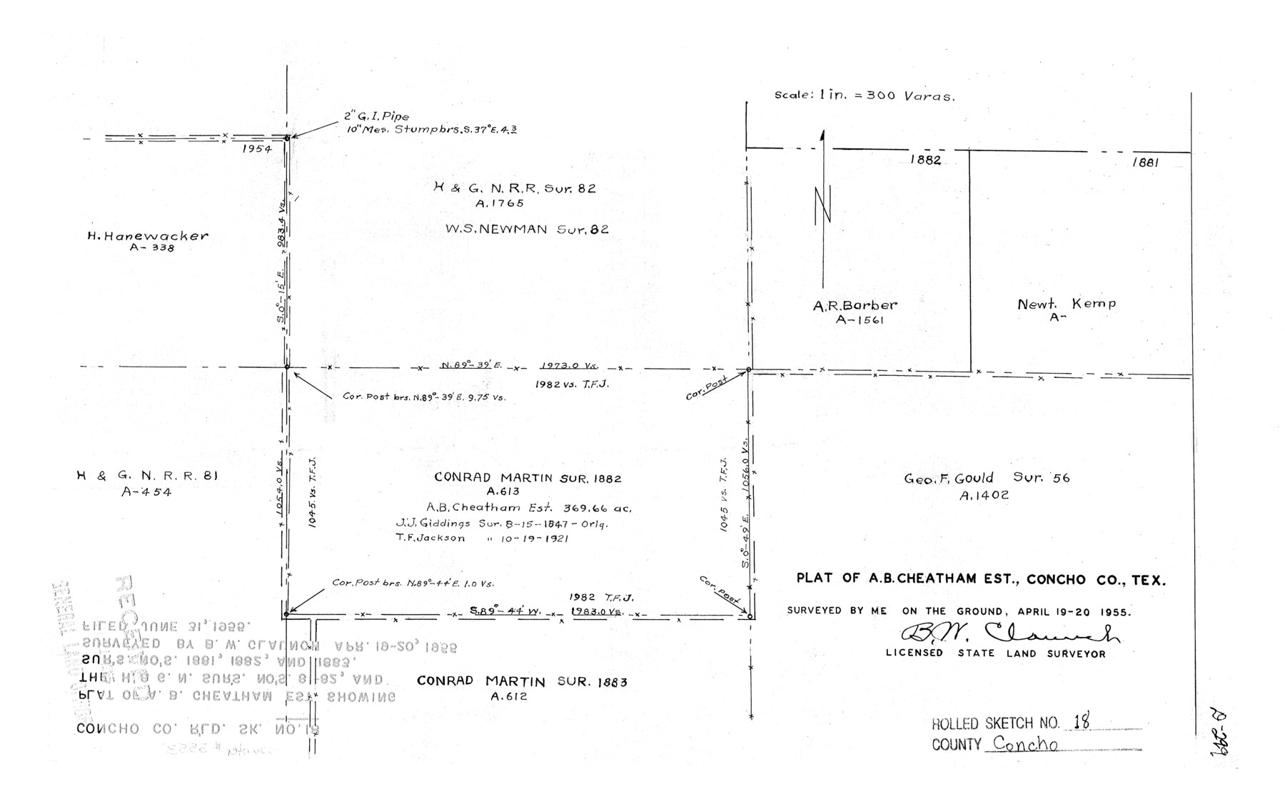
Concho County Rolled Sketch 18
Plat of A.B. Cheatham Est., Concho Co., Tex.
-
Map/Doc
5553
-
Collection
General Map Collection
-
Object Dates
1955/4/20 (Creation Date)
1955/6/30 (File Date)
-
People and Organizations
B.W. Claunch (Surveyor/Engineer)
-
Counties
Concho
-
Subjects
Surveying Rolled Sketch
-
Height x Width
11.4 x 18.3 inches
29.0 x 46.5 cm
Part of: General Map Collection
Flight Mission No. BQR-9K, Frame 47, Brazoria County

Print $20.00
- Digital $50.00
Flight Mission No. BQR-9K, Frame 47, Brazoria County
1952
Size 18.7 x 22.4 inches
Map/Doc 84051
History Salvaged from the Sea

History Salvaged from the Sea
1977
Size 23.0 x 30.4 inches
Map/Doc 96836
Duval County Sketch File 74

Print $42.00
- Digital $50.00
Duval County Sketch File 74
Size 10.1 x 8.8 inches
Map/Doc 21465
Ochiltree County Working Sketch 7

Print $40.00
- Digital $50.00
Ochiltree County Working Sketch 7
1968
Size 26.8 x 56.6 inches
Map/Doc 71320
Flight Mission No. BRA-8M, Frame 149, Jefferson County

Print $20.00
- Digital $50.00
Flight Mission No. BRA-8M, Frame 149, Jefferson County
1953
Size 18.8 x 22.4 inches
Map/Doc 85641

Tyler County Sketch File 5

Print $20.00
- Digital $50.00
Tyler County Sketch File 5
1854
Size 13.2 x 17.4 inches
Map/Doc 12497
Runnels County Rolled Sketch 39

Print $20.00
- Digital $50.00
Runnels County Rolled Sketch 39
Size 34.3 x 31.6 inches
Map/Doc 7526

Foard County Sketch File 35

Print $20.00
- Digital $50.00
Foard County Sketch File 35
Size 26.4 x 25.7 inches
Map/Doc 11496
Pecos County Rolled Sketch 70

Print $40.00
- Digital $50.00
Pecos County Rolled Sketch 70
1929
Size 49.3 x 21.6 inches
Map/Doc 9708
San Patricio County Rolled Sketch 46N

Print $3.00
- Digital $50.00
San Patricio County Rolled Sketch 46N
1983
Size 12.2 x 9.3 inches
Map/Doc 8385
You may also like
Lynn County Rolled Sketch 10

Print $20.00
- Digital $50.00
Lynn County Rolled Sketch 10
Size 13.1 x 18.5 inches
Map/Doc 6646
Flight Mission No. BRA-16M, Frame 164, Jefferson County

Print $20.00
- Digital $50.00
Flight Mission No. BRA-16M, Frame 164, Jefferson County
1953
Size 18.7 x 22.3 inches
Map/Doc 85762
Oldham County Working Sketch 1

Print $20.00
- Digital $50.00
Oldham County Working Sketch 1
1901
Size 40.2 x 24.7 inches
Map/Doc 71323
General Highway Map, Edwards County, Real County, Texas

Print $20.00
General Highway Map, Edwards County, Real County, Texas
1961
Size 18.1 x 24.7 inches
Map/Doc 79452
Potter County Boundary File 6

Print $24.00
- Digital $50.00
Potter County Boundary File 6
Size 14.8 x 9.2 inches
Map/Doc 58027
General Highway Map, Lavaca County, Texas

Print $20.00
General Highway Map, Lavaca County, Texas
1961
Size 24.6 x 18.1 inches
Map/Doc 79566
Brown County Rolled Sketch 3

Print $20.00
- Digital $50.00
Brown County Rolled Sketch 3
1985
Size 25.0 x 36.5 inches
Map/Doc 5353
Northeast Part Pecos County

Print $20.00
- Digital $50.00
Northeast Part Pecos County
1975
Size 36.9 x 43.4 inches
Map/Doc 95611
[I. & G. N. RR. Co. Block I]
![89828, [I. &G. N. RR. Co. Block I], Twichell Survey Records](https://historictexasmaps.com/wmedia_w700/maps/89828-1.tif.jpg)
Print $20.00
- Digital $50.00
[I. & G. N. RR. Co. Block I]
Size 43.0 x 31.7 inches
Map/Doc 89828
[Portion of R. M. Thompson Blocks 1 and 2]
![91122, [Portion of R. M. Thompson Blocks 1 and 2], Twichell Survey Records](https://historictexasmaps.com/wmedia_w700/maps/91122-1.tif.jpg)
Print $3.00
- Digital $50.00
[Portion of R. M. Thompson Blocks 1 and 2]
Size 9.5 x 11.7 inches
Map/Doc 91122
General Highway Map, Upton County, Texas

Print $20.00
General Highway Map, Upton County, Texas
1961
Size 24.7 x 18.1 inches
Map/Doc 79693
Brazoria County Working Sketch 7

Print $20.00
- Digital $50.00
Brazoria County Working Sketch 7
1930
Size 40.9 x 21.1 inches
Map/Doc 67492