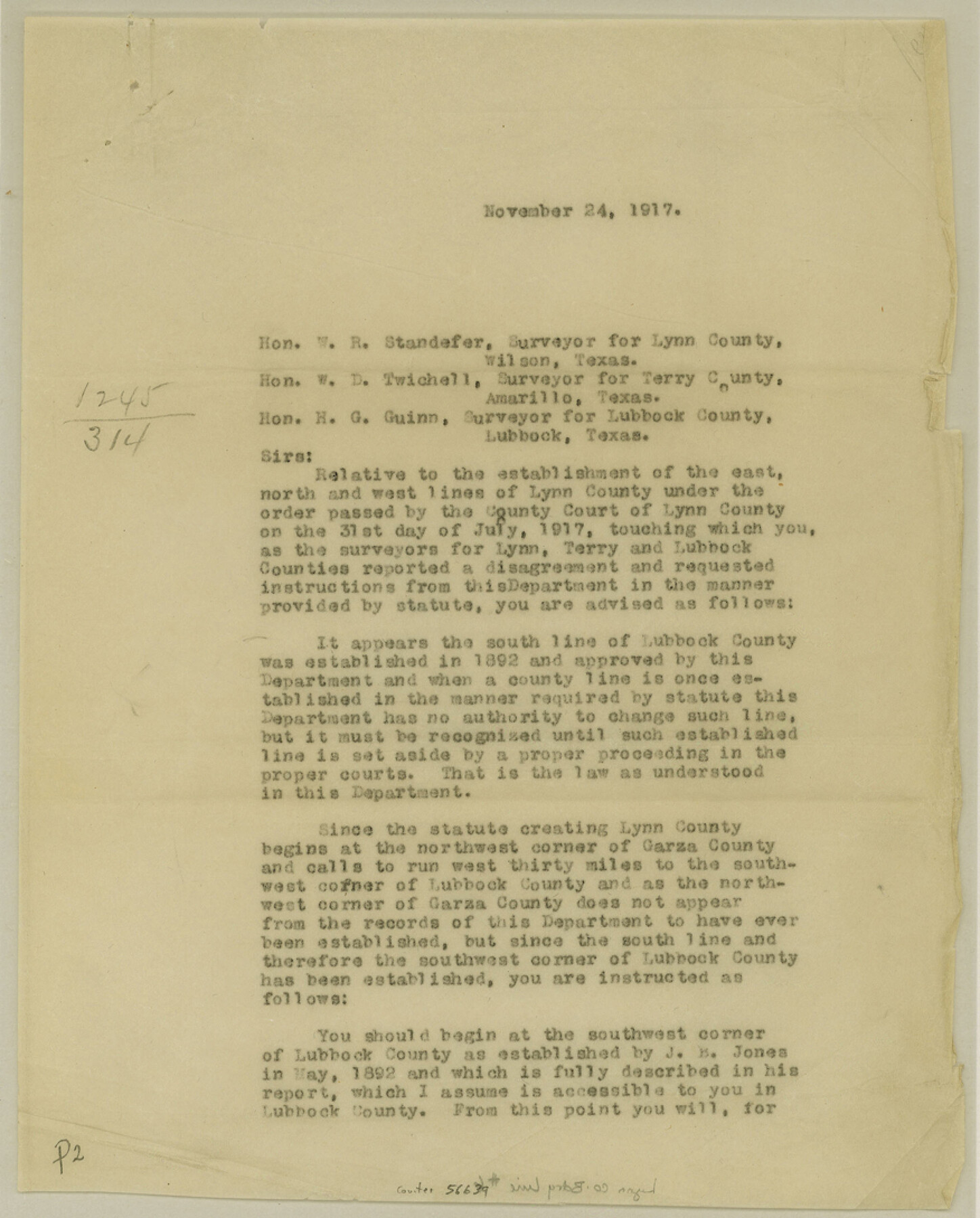
Lynn County Boundary File 6
[Instructions to survey Lynn-Lubbock-Terry Boundary lines]
-
Map/Doc
56639
-
Collection
General Map Collection
-
Counties
Lynn
-
Subjects
County Boundaries
-
Height x Width
10.9 x 8.8 inches
27.7 x 22.4 cm
Part of: General Map Collection
Plan of the Battle of Buena-Vista fought February 22nd and 23rd, 1847

Print $20.00
- Digital $50.00
Plan of the Battle of Buena-Vista fought February 22nd and 23rd, 1847
1847
Size 17.8 x 21.5 inches
Map/Doc 94112
Cooke County Sketch File 22

Print $6.00
- Digital $50.00
Cooke County Sketch File 22
1870
Size 6.4 x 8.2 inches
Map/Doc 19267
Val Verde County Working Sketch 119

Print $40.00
- Digital $50.00
Val Verde County Working Sketch 119
2005
Size 30.5 x 50.0 inches
Map/Doc 83588
Harrison County Sketch File 3

Print $8.00
- Digital $50.00
Harrison County Sketch File 3
Size 13.0 x 8.3 inches
Map/Doc 26036
Lipscomb County Rolled Sketch 2

Print $20.00
- Digital $50.00
Lipscomb County Rolled Sketch 2
1886
Size 24.1 x 30.2 inches
Map/Doc 6628
Flight Mission No. CGI-3G, Frame 12, Cameron County

Print $20.00
- Digital $50.00
Flight Mission No. CGI-3G, Frame 12, Cameron County
1950
Size 19.3 x 19.0 inches
Map/Doc 84531

Taylor County Working Sketch 15

Print $20.00
- Digital $50.00
Taylor County Working Sketch 15
1972
Size 44.1 x 30.4 inches
Map/Doc 69625
Flight Mission No. CRC-4R, Frame 82, Chambers County

Print $20.00
- Digital $50.00
Flight Mission No. CRC-4R, Frame 82, Chambers County
1956
Size 18.7 x 22.6 inches
Map/Doc 84886
Gaines County Sketch File 23

Print $20.00
- Digital $50.00
Gaines County Sketch File 23
1964
Size 20.0 x 22.8 inches
Map/Doc 11529
Old Miscellaneous File 39

Print $10.00
- Digital $50.00
Old Miscellaneous File 39
1893
Size 14.2 x 8.8 inches
Map/Doc 75284
Somervell County Sketch File 1

Print $4.00
- Digital $50.00
Somervell County Sketch File 1
1859
Size 12.8 x 8.1 inches
Map/Doc 36795
You may also like
General Highway Map, San Patricio County, Texas

Print $20.00
General Highway Map, San Patricio County, Texas
1961
Size 18.1 x 24.5 inches
Map/Doc 79647
Flight Mission No. DQO-2K, Frame 94, Galveston County

Print $20.00
- Digital $50.00
Flight Mission No. DQO-2K, Frame 94, Galveston County
1952
Size 18.7 x 22.4 inches
Map/Doc 85021
El Paso County Boundary File 12

Print $16.00
- Digital $50.00
El Paso County Boundary File 12
Size 13.9 x 8.5 inches
Map/Doc 53153

Knox County Working Sketch 19

Print $20.00
- Digital $50.00
Knox County Working Sketch 19
1992
Size 25.0 x 35.6 inches
Map/Doc 70261
Denton County Sketch File 39

Print $16.00
- Digital $50.00
Denton County Sketch File 39
1934
Size 7.8 x 8.9 inches
Map/Doc 20781
Coryell County, Texas

Print $20.00
- Digital $50.00
Coryell County, Texas
1879
Size 23.5 x 29.1 inches
Map/Doc 704
Real County Sketch File 11

Print $8.00
- Digital $50.00
Real County Sketch File 11
1932
Size 11.2 x 8.8 inches
Map/Doc 35065
Collingsworth County Rolled Sketch 1

Print $40.00
- Digital $50.00
Collingsworth County Rolled Sketch 1
1941
Size 54.2 x 24.0 inches
Map/Doc 9664
Erath County Working Sketch 5

Print $20.00
- Digital $50.00
Erath County Working Sketch 5
1920
Size 27.6 x 17.1 inches
Map/Doc 69086
Map of Wheeler County

Print $20.00
- Digital $50.00
Map of Wheeler County
1899
Size 39.9 x 32.3 inches
Map/Doc 4138
