Ochiltree County Boundary File 9
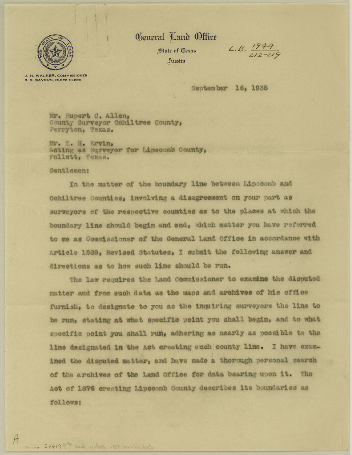
[Letter regarding disagreement between surveyors for Ochiltree and Lipscomb Counties]
-
Map/Doc
57719
-
Collection
General Map Collection
-
Counties
Ochiltree
-
Subjects
County Boundaries
-
Height x Width
11.2 x 8.7 inches
28.5 x 22.1 cm
Part of: General Map Collection
Brewster County Working Sketch 41

Print $20.00
- Digital $50.00
Brewster County Working Sketch 41
1945
Size 30.3 x 38.4 inches
Map/Doc 67575
Flight Mission No. CGI-4N, Frame 191, Cameron County

Print $20.00
- Digital $50.00
Flight Mission No. CGI-4N, Frame 191, Cameron County
1955
Size 18.6 x 22.2 inches
Map/Doc 84694
Bailey County Working Sketch 2

Print $20.00
- Digital $50.00
Bailey County Working Sketch 2
1920
Size 17.8 x 16.2 inches
Map/Doc 67589
Cameron County Rolled Sketch 7

Print $20.00
- Digital $50.00
Cameron County Rolled Sketch 7
1926
Size 27.4 x 31.8 inches
Map/Doc 8563
Flight Mission No. DQN-1K, Frame 119, Calhoun County

Print $20.00
- Digital $50.00
Flight Mission No. DQN-1K, Frame 119, Calhoun County
1953
Size 18.6 x 22.1 inches
Map/Doc 84185
Township 12 South Range 14 West and 15 West, South Western District, Louisiana

Print $20.00
- Digital $50.00
Township 12 South Range 14 West and 15 West, South Western District, Louisiana
1838
Size 19.5 x 24.5 inches
Map/Doc 65856
Wilson County Working Sketch 14

Print $20.00
- Digital $50.00
Wilson County Working Sketch 14
1987
Size 31.9 x 36.2 inches
Map/Doc 72594
Starr County Sketch File 11

Print $28.00
- Digital $50.00
Starr County Sketch File 11
1885
Size 12.8 x 8.1 inches
Map/Doc 36865
Borden County Working Sketch 4

Print $20.00
- Digital $50.00
Borden County Working Sketch 4
1944
Size 21.7 x 23.7 inches
Map/Doc 67464
Smith County Sketch File 19

Print $42.00
- Digital $50.00
Smith County Sketch File 19
1850
Size 8.1 x 13.0 inches
Map/Doc 36794
Flight Mission No. DAG-26K, Frame 59, Matagorda County

Print $20.00
- Digital $50.00
Flight Mission No. DAG-26K, Frame 59, Matagorda County
1953
Size 18.5 x 22.3 inches
Map/Doc 86579
Clay County Rolled Sketch 1

Print $20.00
- Digital $50.00
Clay County Rolled Sketch 1
1940
Size 47.0 x 37.9 inches
Map/Doc 8621
You may also like
USGS Topographic, De Kalb NW, Texas Quadrangle

Print $20.00
- Digital $50.00
USGS Topographic, De Kalb NW, Texas Quadrangle
1950
Size 26.8 x 21.6 inches
Map/Doc 77604

Flight Mission No. BRA-7M, Frame 75, Jefferson County

Print $20.00
- Digital $50.00
Flight Mission No. BRA-7M, Frame 75, Jefferson County
1953
Size 18.6 x 22.2 inches
Map/Doc 85497
Flight Mission No. BQY-15M, Frame 19, Harris County

Print $20.00
- Digital $50.00
Flight Mission No. BQY-15M, Frame 19, Harris County
1953
Size 18.6 x 22.4 inches
Map/Doc 85317
Coryell County Working Sketch 14

Print $20.00
- Digital $50.00
Coryell County Working Sketch 14
1950
Size 19.4 x 17.5 inches
Map/Doc 68221
Colton's New Map of the State of Texas Compiled from J. De Cordova's large Map

Print $20.00
- Digital $50.00
Colton's New Map of the State of Texas Compiled from J. De Cordova's large Map
1859
Size 17.9 x 28.3 inches
Map/Doc 90094
Dimmit County Sketch File 21a

Print $12.00
- Digital $50.00
Dimmit County Sketch File 21a
1901
Size 8.9 x 7.8 inches
Map/Doc 21123
Eastland County Working Sketch 35

Print $20.00
- Digital $50.00
Eastland County Working Sketch 35
1962
Size 24.0 x 21.6 inches
Map/Doc 68816
Kimble County Sketch File 37

Print $4.00
- Digital $50.00
Kimble County Sketch File 37
1892
Size 11.2 x 8.9 inches
Map/Doc 28990
Edward K. Warren Subdivision No. 1 Block-W Situated in Bailey, Lamb, Parmer, and Castro Counties, Texas

Print $20.00
- Digital $50.00
Edward K. Warren Subdivision No. 1 Block-W Situated in Bailey, Lamb, Parmer, and Castro Counties, Texas
1913
Size 17.6 x 14.5 inches
Map/Doc 92163
Duval County Sketch File 28

Print $20.00
- Digital $50.00
Duval County Sketch File 28
1932
Size 26.2 x 24.8 inches
Map/Doc 11387
Flight Mission No. CGI-3N, Frame 120, Cameron County

Print $20.00
- Digital $50.00
Flight Mission No. CGI-3N, Frame 120, Cameron County
1954
Size 18.8 x 22.3 inches
Map/Doc 84593