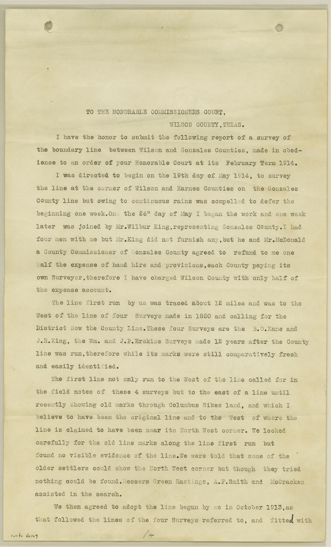
Wilson County Boundary File 5
Field Notes and Plat of the County Boundary between Gonzales and Wilson Cos.
-
Map/Doc
60109
-
Collection
General Map Collection
-
Counties
Wilson
-
Subjects
County Boundaries
-
Height x Width
14.4 x 8.7 inches
36.6 x 22.1 cm
Part of: General Map Collection
Galveston to Rio Grande

Print $20.00
- Digital $50.00
Galveston to Rio Grande
1961
Size 44.4 x 37.2 inches
Map/Doc 69954
Navigation Maps of Gulf Intracoastal Waterway, Port Arthur to Brownsville, Texas

Print $4.00
- Digital $50.00
Navigation Maps of Gulf Intracoastal Waterway, Port Arthur to Brownsville, Texas
1951
Size 16.7 x 21.5 inches
Map/Doc 65418
Pecos County Working Sketch 37

Print $20.00
- Digital $50.00
Pecos County Working Sketch 37
1939
Size 30.0 x 43.0 inches
Map/Doc 71509
Hudspeth County Sketch File 20a

Print $10.00
- Digital $50.00
Hudspeth County Sketch File 20a
Size 10.8 x 8.2 inches
Map/Doc 26964
Andrews County Working Sketch 11

Print $20.00
- Digital $50.00
Andrews County Working Sketch 11
1955
Size 20.6 x 25.2 inches
Map/Doc 67057
San Augustine County Working Sketch 14

Print $20.00
- Digital $50.00
San Augustine County Working Sketch 14
1958
Size 22.7 x 26.1 inches
Map/Doc 63702
[Anderson County]
![5051, [Anderson County], General Map Collection](https://historictexasmaps.com/wmedia_w700/maps/5051-GC.tif.jpg)
Print $20.00
- Digital $50.00
[Anderson County]
1848
Size 26.0 x 19.9 inches
Map/Doc 5051
Gulf Intracoastal Waterway - Tributary Channel to Aransas Pass, Location of Spoil Disposal Areas

Print $20.00
- Digital $50.00
Gulf Intracoastal Waterway - Tributary Channel to Aransas Pass, Location of Spoil Disposal Areas
1961
Size 31.5 x 41.9 inches
Map/Doc 61828
Austin Old and New, a Mapguide to the Heart of the City including Capitol Complex & Government Buildings, Downtown Streets and Buildings, the University of Texas, Historical Sites, Parks & Trails, Sixth Street, Town Lake, Museums

Austin Old and New, a Mapguide to the Heart of the City including Capitol Complex & Government Buildings, Downtown Streets and Buildings, the University of Texas, Historical Sites, Parks & Trails, Sixth Street, Town Lake, Museums
Size 25.4 x 31.3 inches
Map/Doc 94379
Sulphur River, Turner Lake Sheet, Cuthand Creek

Print $20.00
- Digital $50.00
Sulphur River, Turner Lake Sheet, Cuthand Creek
1922
Size 28.5 x 34.3 inches
Map/Doc 65157
Winkler County Sketch File 15

Print $10.00
- Digital $50.00
Winkler County Sketch File 15
1944
Size 14.3 x 8.6 inches
Map/Doc 40488
Gonzales County Working Sketch 8

Print $20.00
- Digital $50.00
Gonzales County Working Sketch 8
1981
Size 19.0 x 16.7 inches
Map/Doc 63224
You may also like
[Surveys in Austin's Colony near La Bahia Road]
![200, [Surveys in Austin's Colony near La Bahia Road], General Map Collection](https://historictexasmaps.com/wmedia_w700/maps/200.tif.jpg)
Print $20.00
- Digital $50.00
[Surveys in Austin's Colony near La Bahia Road]
1821
Size 10.4 x 20.2 inches
Map/Doc 200
General Highway Map Lamb County, Texas

Print $20.00
- Digital $50.00
General Highway Map Lamb County, Texas
1949
Size 19.0 x 26.0 inches
Map/Doc 92172
Val Verde County

Print $20.00
- Digital $50.00
Val Verde County
1944
Size 42.0 x 37.0 inches
Map/Doc 63103
Stephens County Working Sketch 10

Print $40.00
- Digital $50.00
Stephens County Working Sketch 10
1921
Size 36.1 x 64.1 inches
Map/Doc 63953
Sketch Showing Reed and Meeker Vacancy, Cochran County, Texas

Print $20.00
- Digital $50.00
Sketch Showing Reed and Meeker Vacancy, Cochran County, Texas
Size 28.9 x 20.3 inches
Map/Doc 92514
Cooke County Working Sketch 16

Print $20.00
- Digital $50.00
Cooke County Working Sketch 16
1949
Size 29.8 x 28.9 inches
Map/Doc 68253
Dallam County Working Sketch 1

Print $20.00
- Digital $50.00
Dallam County Working Sketch 1
1905
Size 15.9 x 13.6 inches
Map/Doc 68586
The Texas and Oklahoma Official Railway and Hotel Guide Map

Print $20.00
The Texas and Oklahoma Official Railway and Hotel Guide Map
1912
Size 23.4 x 23.9 inches
Map/Doc 76276
Flight Mission No. CRE-2R, Frame 88, Jackson County

Print $20.00
- Digital $50.00
Flight Mission No. CRE-2R, Frame 88, Jackson County
1956
Size 15.9 x 15.9 inches
Map/Doc 85360
Polk County Working Sketch 8

Print $20.00
- Digital $50.00
Polk County Working Sketch 8
1934
Size 24.2 x 30.5 inches
Map/Doc 71623
English Field Notes of the Spanish Archives - Book J. Strode

English Field Notes of the Spanish Archives - Book J. Strode
1835
Map/Doc 96549
