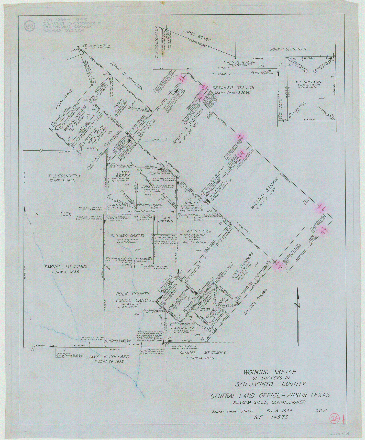
San Jacinto County Working Sketch 26
-
Map/Doc
63739
-
Collection
General Map Collection
-
Object Dates
2/8/1944 (Creation Date)
-
People and Organizations
Otto G. Kurio (Draftsman)
-
Counties
San Jacinto
-
Subjects
Surveying Working Sketch
-
Height x Width
27.7 x 23.0 inches
70.4 x 58.4 cm
-
Scale
1" = 500 varas
Part of: General Map Collection
Hood County Sketch File 27

Print $4.00
- Digital $50.00
Hood County Sketch File 27
1873
Size 12.9 x 8.5 inches
Map/Doc 26629
Gaines County Working Sketch 29

Print $20.00
- Digital $50.00
Gaines County Working Sketch 29
1984
Size 32.3 x 42.9 inches
Map/Doc 69329
Hardin County Sketch File 71f

Print $20.00
- Digital $50.00
Hardin County Sketch File 71f
1997
Size 25.2 x 36.7 inches
Map/Doc 11643
[Maps of surveys in Reeves & Culberson Cos]
![61144, [Maps of surveys in Reeves & Culberson Cos], General Map Collection](https://historictexasmaps.com/wmedia_w700/maps/61144.tif.jpg)
Print $20.00
- Digital $50.00
[Maps of surveys in Reeves & Culberson Cos]
1937
Size 30.9 x 25.1 inches
Map/Doc 61144
Erath County Sketch File 26

Print $6.00
- Digital $50.00
Erath County Sketch File 26
1896
Size 9.5 x 8.1 inches
Map/Doc 22306
Edwards County Working Sketch 137, revised

Print $20.00
- Digital $50.00
Edwards County Working Sketch 137, revised
1997
Size 33.6 x 35.1 inches
Map/Doc 69014
Hidalgo County Working Sketch Graphic Index

Print $20.00
- Digital $50.00
Hidalgo County Working Sketch Graphic Index
1977
Size 45.7 x 34.7 inches
Map/Doc 76577
Harris County Sketch File 69a

Print $20.00
- Digital $50.00
Harris County Sketch File 69a
1938
Size 19.4 x 21.3 inches
Map/Doc 11663
San Jacinto River and Tributaries, Texas - Survey of 1939

Print $20.00
- Digital $50.00
San Jacinto River and Tributaries, Texas - Survey of 1939
1939
Size 28.0 x 40.3 inches
Map/Doc 60305
Val Verde County Rolled Sketch 39

Print $20.00
- Digital $50.00
Val Verde County Rolled Sketch 39
Size 21.7 x 33.9 inches
Map/Doc 8115
Young County Rolled Sketch 2

Print $20.00
- Digital $50.00
Young County Rolled Sketch 2
Size 26.2 x 25.0 inches
Map/Doc 8292
Map of Fort Bend Co.

Print $20.00
- Digital $50.00
Map of Fort Bend Co.
1906
Size 38.4 x 43.8 inches
Map/Doc 87154
You may also like
Hill County Sketch File 27

Print $4.00
- Digital $50.00
Hill County Sketch File 27
1873
Size 10.4 x 8.2 inches
Map/Doc 26528
Lubbock County Texas

Print $20.00
- Digital $50.00
Lubbock County Texas
Size 42.7 x 46.7 inches
Map/Doc 89892
Sabine County

Print $20.00
- Digital $50.00
Sabine County
1920
Size 44.6 x 35.1 inches
Map/Doc 16805
Coke County Working Sketch 29

Print $20.00
- Digital $50.00
Coke County Working Sketch 29
1982
Size 19.6 x 25.4 inches
Map/Doc 68066
Galveston County NRC Article 33.136 Location Key Sheet

Print $20.00
- Digital $50.00
Galveston County NRC Article 33.136 Location Key Sheet
1994
Size 27.0 x 23.0 inches
Map/Doc 77018
Live Oak County Sketch File 35

Print $12.00
- Digital $50.00
Live Oak County Sketch File 35
1969
Size 11.0 x 8.7 inches
Map/Doc 30339
Terrell County Working Sketch 74

Print $20.00
- Digital $50.00
Terrell County Working Sketch 74
1981
Size 37.5 x 24.6 inches
Map/Doc 69595
Van Zandt County Sketch File 7

Print $8.00
- Digital $50.00
Van Zandt County Sketch File 7
1849
Size 5.2 x 7.4 inches
Map/Doc 39375

Anderson County Sketch File 17

Print $4.00
- Digital $50.00
Anderson County Sketch File 17
1871
Size 10.2 x 7.7 inches
Map/Doc 12789
The Republic County of Jackson. January 29, 1842

Print $20.00
The Republic County of Jackson. January 29, 1842
2020
Size 15.6 x 21.8 inches
Map/Doc 96189
Andrews County Rolled Sketch 20

Print $20.00
- Digital $50.00
Andrews County Rolled Sketch 20
Size 31.6 x 40.0 inches
Map/Doc 8395