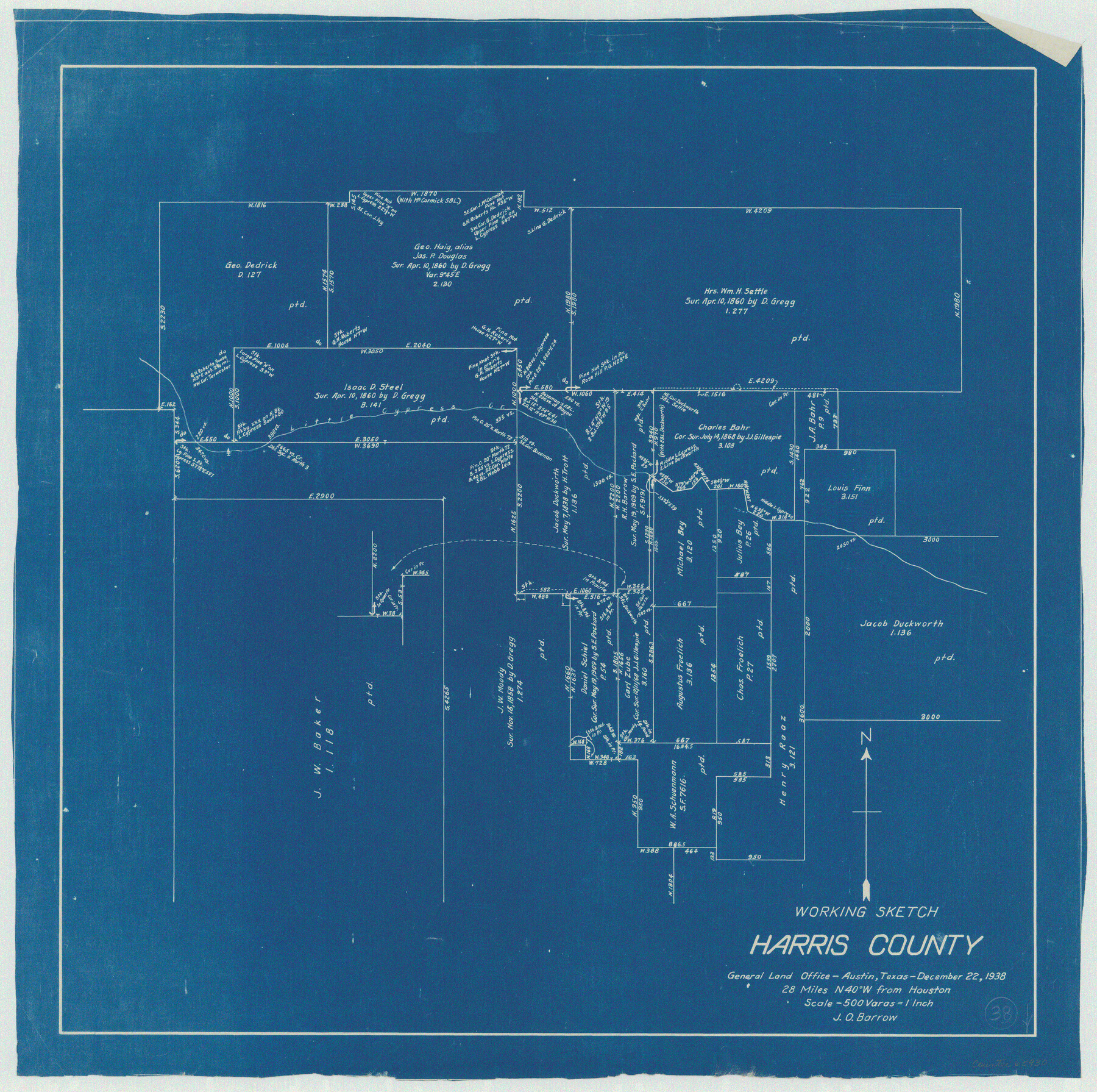
Harris County Working Sketch 38
-
Map/Doc
65930
-
Collection
General Map Collection
-
Object Dates
12/22/1938 (Creation Date)
-
People and Organizations
J.O. Barrow (Draftsman)
-
Counties
Harris
-
Subjects
Surveying Working Sketch
-
Height x Width
23.6 x 23.7 inches
59.9 x 60.2 cm
-
Scale
1" = 500 varas
Part of: General Map Collection
Travis County Sketch File 73

Print $8.00
- Digital $50.00
Travis County Sketch File 73
1848
Size 12.8 x 8.3 inches
Map/Doc 38464
Flight Mission No. CRC-4R, Frame 186, Chambers County

Print $20.00
- Digital $50.00
Flight Mission No. CRC-4R, Frame 186, Chambers County
1956
Size 18.6 x 22.3 inches
Map/Doc 84937
Val Verde County Working Sketch 109

Print $20.00
- Digital $50.00
Val Verde County Working Sketch 109
1988
Size 41.4 x 31.2 inches
Map/Doc 72244
Flight Mission No. BQY-14M, Frame 184, Harris County

Print $20.00
- Digital $50.00
Flight Mission No. BQY-14M, Frame 184, Harris County
1953
Size 18.6 x 22.4 inches
Map/Doc 85300
Sketch of Maneuver Tract

Print $20.00
- Digital $50.00
Sketch of Maneuver Tract
1870
Size 18.5 x 14.4 inches
Map/Doc 2184
Uvalde County Working Sketch 63

Print $20.00
- Digital $50.00
Uvalde County Working Sketch 63
1995
Size 26.8 x 42.0 inches
Map/Doc 72133
Bailey County Rolled Sketch 6

Print $20.00
- Digital $50.00
Bailey County Rolled Sketch 6
Size 17.4 x 12.9 inches
Map/Doc 5111
Gaines County

Print $40.00
- Digital $50.00
Gaines County
1956
Size 43.8 x 55.0 inches
Map/Doc 73154
Howard County Sketch File 9

Print $20.00
- Digital $50.00
Howard County Sketch File 9
Size 19.4 x 15.9 inches
Map/Doc 11797
Guadalupe County Sketch File 10

Print $4.00
- Digital $50.00
Guadalupe County Sketch File 10
1862
Size 8.7 x 14.5 inches
Map/Doc 24679
Llano County Working Sketch 12

Print $20.00
- Digital $50.00
Llano County Working Sketch 12
Size 18.8 x 12.5 inches
Map/Doc 70630
Callahan County Working Sketch 1

Print $20.00
- Digital $50.00
Callahan County Working Sketch 1
1939
Size 30.6 x 32.6 inches
Map/Doc 67883
You may also like
Clay County Sketch File 24

Print $4.00
- Digital $50.00
Clay County Sketch File 24
1881
Size 18.9 x 23.0 inches
Map/Doc 11087
Dawson County Working Sketch 17

Print $20.00
- Digital $50.00
Dawson County Working Sketch 17
1961
Size 33.3 x 29.9 inches
Map/Doc 68561
Right of Way and Track Map for The Missouri, Kansas & Texas Railway of Texas

Print $40.00
- Digital $50.00
Right of Way and Track Map for The Missouri, Kansas & Texas Railway of Texas
1918
Size 25.9 x 56.0 inches
Map/Doc 64527
Young County Working Sketch 7

Print $20.00
- Digital $50.00
Young County Working Sketch 7
1919
Size 24.3 x 19.8 inches
Map/Doc 62030
[Plat of Trinity River w/ Midstream Profile in Liberty County by US Government 1899]
![65339, [Plat of Trinity River w/ Midstream Profile in Liberty County by US Government 1899], General Map Collection](https://historictexasmaps.com/wmedia_w700/maps/65339.tif.jpg)
Print $20.00
- Digital $50.00
[Plat of Trinity River w/ Midstream Profile in Liberty County by US Government 1899]
1899
Size 12.8 x 17.6 inches
Map/Doc 65339
Titus County Sketch File 13

Print $6.00
- Digital $50.00
Titus County Sketch File 13
1929
Size 9.0 x 8.8 inches
Map/Doc 38154
Current Miscellaneous File 60

Print $4.00
- Digital $50.00
Current Miscellaneous File 60
1955
Size 11.9 x 9.4 inches
Map/Doc 74064
Cherokee County Sketch File 31

Print $6.00
- Digital $50.00
Cherokee County Sketch File 31
1934
Size 14.0 x 8.9 inches
Map/Doc 18184
Kendall County Working Sketch 12

Print $20.00
- Digital $50.00
Kendall County Working Sketch 12
1966
Size 27.2 x 33.2 inches
Map/Doc 66684
San Jacinto County Sketch File 14

Print $20.00
San Jacinto County Sketch File 14
Size 15.8 x 18.2 inches
Map/Doc 12281
[Sketch for Mineral Application 1112 - Colorado River, H. E. Chambers]
![65637, [Sketch for Mineral Application 1112 - Colorado River, H. E. Chambers], General Map Collection](https://historictexasmaps.com/wmedia_w700/maps/65637.tif.jpg)
Print $20.00
- Digital $50.00
[Sketch for Mineral Application 1112 - Colorado River, H. E. Chambers]
1918
Size 5.5 x 8.5 inches
Map/Doc 65637
Milam District

Print $20.00
- Digital $50.00
Milam District
1854
Size 30.2 x 18.9 inches
Map/Doc 3859