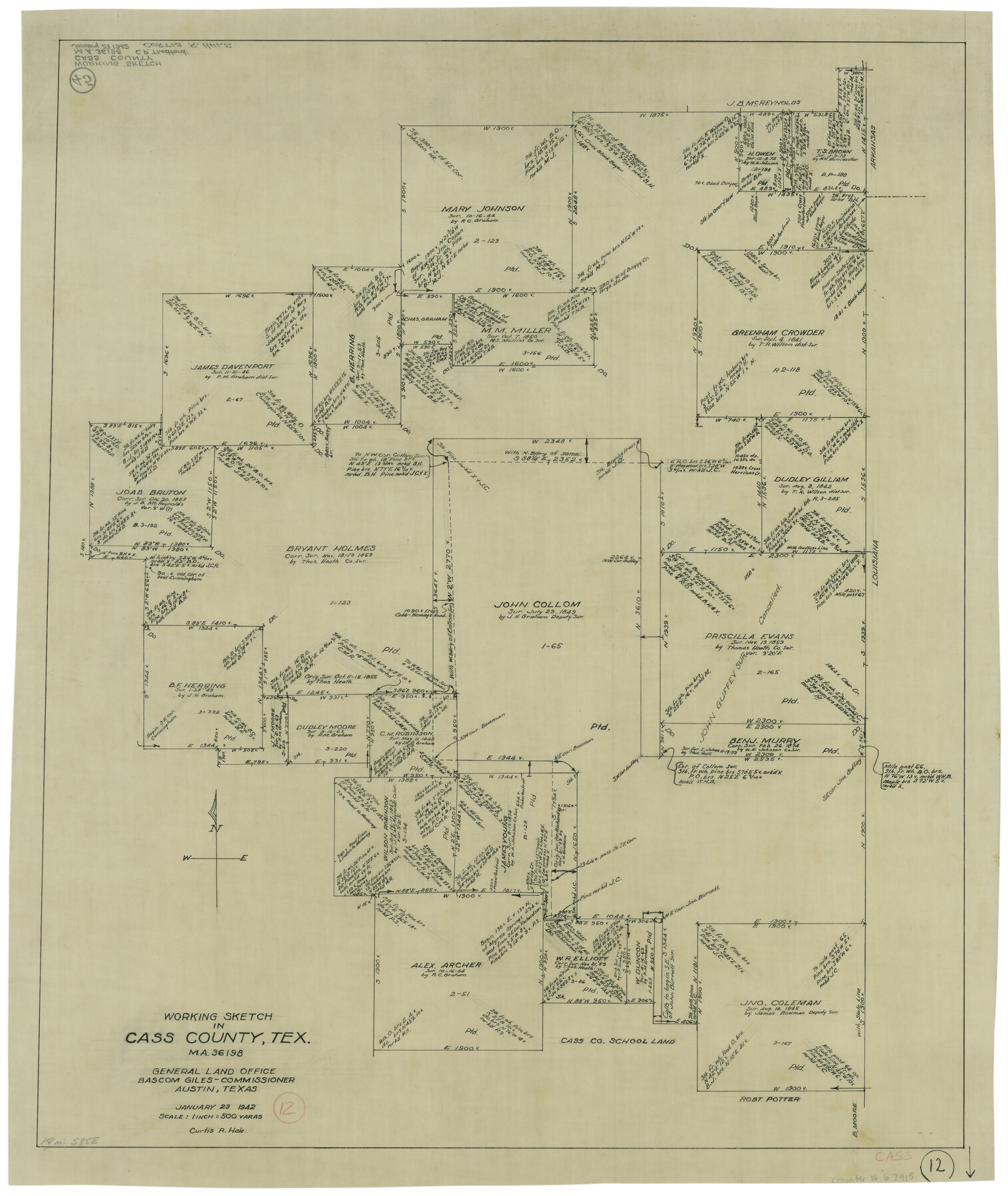
Cass County Working Sketch 12
-
Map/Doc
67915
-
Collection
General Map Collection
-
Object Dates
1/23/1942 (Creation Date)
-
People and Organizations
Curtis R. Hale (Draftsman)
-
Counties
Cass
-
Subjects
Surveying Working Sketch
-
Height x Width
27.0 x 22.9 inches
68.6 x 58.2 cm
-
Scale
1" = 500 varas
Part of: General Map Collection
Castro County Sketch File 4l

Print $4.00
- Digital $50.00
Castro County Sketch File 4l
Size 13.5 x 8.6 inches
Map/Doc 17487
Copy of a portion of Arista's map

Print $20.00
- Digital $50.00
Copy of a portion of Arista's map
1847
Size 27.5 x 18.3 inches
Map/Doc 73057
Voyages Autour du Monde, et vers les deux poles par terre et par mer - Tome Second

Voyages Autour du Monde, et vers les deux poles par terre et par mer - Tome Second
1782
Map/Doc 97086
Burnet County Sketch File 42

Print $28.00
- Digital $50.00
Burnet County Sketch File 42
1950
Size 9.9 x 8.8 inches
Map/Doc 16760
Sterling County Boundary File 1

Print $56.00
- Digital $50.00
Sterling County Boundary File 1
Size 9.0 x 8.7 inches
Map/Doc 58919
Sterling County

Print $20.00
- Digital $50.00
Sterling County
1971
Size 42.8 x 31.1 inches
Map/Doc 77427
La Salle County Sketch File 46

Print $20.00
- Digital $50.00
La Salle County Sketch File 46
Size 14.1 x 8.6 inches
Map/Doc 29603
Freestone County

Print $40.00
- Digital $50.00
Freestone County
1988
Size 49.0 x 43.4 inches
Map/Doc 95502
Mills County Sketch File 5

Print $4.00
- Digital $50.00
Mills County Sketch File 5
Size 11.5 x 8.3 inches
Map/Doc 31652
Jeff Davis County Working Sketch 32

Print $40.00
- Digital $50.00
Jeff Davis County Working Sketch 32
1975
Size 66.7 x 43.7 inches
Map/Doc 66527
Red River County Rolled Sketch 5

Print $20.00
- Digital $50.00
Red River County Rolled Sketch 5
Size 33.5 x 32.5 inches
Map/Doc 9842
Archer County Sketch File 14

Print $40.00
- Digital $50.00
Archer County Sketch File 14
1884
Size 19.6 x 23.5 inches
Map/Doc 10826
You may also like
Wichita County Boundary File 2

Print $30.00
- Digital $50.00
Wichita County Boundary File 2
Size 9.1 x 4.7 inches
Map/Doc 59900
Calhoun County Rolled Sketch 33

Print $73.00
- Digital $50.00
Calhoun County Rolled Sketch 33
1979
Size 10.0 x 15.2 inches
Map/Doc 43687
The United States of North America with the British Territories and Those of Spain, according to the Treaty of 1784

Print $20.00
- Digital $50.00
The United States of North America with the British Territories and Those of Spain, according to the Treaty of 1784
1796
Size 23.6 x 30.8 inches
Map/Doc 95738
[Map of Florida]
![96622, [Map of Florida], Cobb Digital Map Collection](https://historictexasmaps.com/wmedia_w700/maps/96622.tif.jpg)
Print $20.00
- Digital $50.00
[Map of Florida]
1869
Size 9.0 x 9.6 inches
Map/Doc 96622
Map of Surveys Made for the T&PRRCo in Tom Green & Martin Counties, Blocks 40, 41, 42, 43, 44, 45 & 46, Reserve West of the Colorado

Print $20.00
- Digital $50.00
Map of Surveys Made for the T&PRRCo in Tom Green & Martin Counties, Blocks 40, 41, 42, 43, 44, 45 & 46, Reserve West of the Colorado
1876
Size 42.3 x 46.0 inches
Map/Doc 2227
Concho County Sketch File 8 1/4

Print $20.00
- Digital $50.00
Concho County Sketch File 8 1/4
Size 23.4 x 15.0 inches
Map/Doc 11149
[Southwest corner of county covering Blks. 24 and B9]
![90489, [Southwest corner of county covering Blks. 24 and B9], Twichell Survey Records](https://historictexasmaps.com/wmedia_w700/maps/90489-1.tif.jpg)
Print $20.00
- Digital $50.00
[Southwest corner of county covering Blks. 24 and B9]
1905
Size 16.7 x 13.9 inches
Map/Doc 90489
Pecos County Rolled Sketch 42

Print $20.00
- Digital $50.00
Pecos County Rolled Sketch 42
1909
Size 19.6 x 41.0 inches
Map/Doc 7220
Presidio County Rolled Sketch 74

Print $20.00
- Digital $50.00
Presidio County Rolled Sketch 74
Size 20.5 x 14.0 inches
Map/Doc 7362
Map of Frio County, Texas

Print $20.00
- Digital $50.00
Map of Frio County, Texas
1879
Size 22.8 x 21.9 inches
Map/Doc 545
Hunt County Working Sketch 4

Print $20.00
- Digital $50.00
Hunt County Working Sketch 4
1923
Size 21.3 x 30.5 inches
Map/Doc 66351
Treaty to Resolve Pending Boundary Differences and Maintain the Rio Grande and Colorado River as the International Boundary Between the United States of American and Mexico

Print $4.00
- Digital $50.00
Treaty to Resolve Pending Boundary Differences and Maintain the Rio Grande and Colorado River as the International Boundary Between the United States of American and Mexico
1970
Size 12.3 x 19.0 inches
Map/Doc 83098