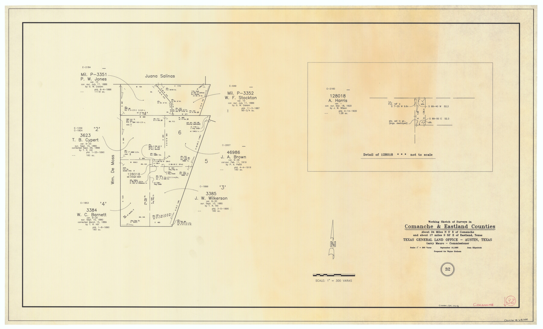
Comanche County Working Sketch 32
-
Map/Doc
68166
-
Collection
General Map Collection
-
Object Dates
9/15/1992 (Creation Date)
-
People and Organizations
Joan Kilpatrick (Draftsman)
-
Counties
Comanche Eastland
-
Subjects
Surveying Working Sketch
-
Height x Width
23.5 x 38.8 inches
59.7 x 98.6 cm
-
Scale
1" = 300 varas
Part of: General Map Collection
Harrison County Sketch File 20

Print $20.00
- Digital $50.00
Harrison County Sketch File 20
1946
Size 26.4 x 21.8 inches
Map/Doc 11693
Land grants from the state of Tamaulipas in the trans-Nueces

Land grants from the state of Tamaulipas in the trans-Nueces
2009
Size 11.0 x 8.5 inches
Map/Doc 94040
Garza County Boundary File 2a

Print $8.00
- Digital $50.00
Garza County Boundary File 2a
Size 14.4 x 8.9 inches
Map/Doc 53675
Young County Working Sketch 17

Print $20.00
- Digital $50.00
Young County Working Sketch 17
1958
Size 20.7 x 28.6 inches
Map/Doc 62040
University Land Field Notes for Blocks 19 and 20 in Pecos County

University Land Field Notes for Blocks 19 and 20 in Pecos County
Map/Doc 81724
Freestone County Working Sketch 3

Print $20.00
- Digital $50.00
Freestone County Working Sketch 3
1914
Size 18.8 x 16.2 inches
Map/Doc 69245
Taylor County Sketch File 21

Print $10.00
- Digital $50.00
Taylor County Sketch File 21
1962
Size 11.3 x 8.8 inches
Map/Doc 37821
Crockett County

Print $40.00
- Digital $50.00
Crockett County
1882
Size 57.6 x 31.6 inches
Map/Doc 88865
Val Verde County Sketch File 18

Print $8.00
- Digital $50.00
Val Verde County Sketch File 18
1883
Size 13.1 x 8.4 inches
Map/Doc 39225
Jack County Sketch File 4

Print $4.00
- Digital $50.00
Jack County Sketch File 4
1857
Size 9.0 x 12.7 inches
Map/Doc 27506
Parker County Sketch File 18

Print $4.00
- Digital $50.00
Parker County Sketch File 18
1876
Size 8.9 x 6.3 inches
Map/Doc 33554
Hydrography Survey H-6395 Off Coast of Texas, Aransas Pass to Corpus Christi Pass in the Gulf of Mexico

Print $40.00
- Digital $50.00
Hydrography Survey H-6395 Off Coast of Texas, Aransas Pass to Corpus Christi Pass in the Gulf of Mexico
1938
Size 56.1 x 33.6 inches
Map/Doc 2696
You may also like
Galveston Bay and Approaches

Print $20.00
- Digital $50.00
Galveston Bay and Approaches
1961
Size 46.2 x 34.1 inches
Map/Doc 69878
Irion County Sketch File 4

Print $12.00
- Digital $50.00
Irion County Sketch File 4
1900
Size 13.7 x 8.8 inches
Map/Doc 27457
Atascosa County Sketch File 15

Print $6.00
- Digital $50.00
Atascosa County Sketch File 15
1879
Size 7.1 x 13.5 inches
Map/Doc 13775
Brewster County Boundary File 1a

Print $80.00
- Digital $50.00
Brewster County Boundary File 1a
Size 94.0 x 13.8 inches
Map/Doc 50738
[Map of Nacogdoches County]
![93369, [Map of Nacogdoches County], General Map Collection](https://historictexasmaps.com/wmedia_w700/maps/93369-1.tif.jpg)
Print $40.00
- Digital $50.00
[Map of Nacogdoches County]
1840
Size 79.3 x 36.8 inches
Map/Doc 93369
Brewster County Rolled Sketch 97

Print $20.00
- Digital $50.00
Brewster County Rolled Sketch 97
1952
Size 31.6 x 30.7 inches
Map/Doc 5254
Jasper County Sketch File 25

Print $16.00
- Digital $50.00
Jasper County Sketch File 25
1941
Size 14.2 x 8.7 inches
Map/Doc 27826
Aransas County Boundary File 3

Print $16.00
- Digital $50.00
Aransas County Boundary File 3
Size 10.6 x 8.0 inches
Map/Doc 49782
[Texas & Pacific Railway through Callahan County]
![64239, [Texas & Pacific Railway through Callahan County], General Map Collection](https://historictexasmaps.com/wmedia_w700/maps/64239.tif.jpg)
Print $20.00
- Digital $50.00
[Texas & Pacific Railway through Callahan County]
1918
Size 21.1 x 9.3 inches
Map/Doc 64239
Hutchinson County Working Sketch 8

Print $20.00
- Digital $50.00
Hutchinson County Working Sketch 8
1919
Size 24.8 x 16.7 inches
Map/Doc 66366
Val Verde County Working Sketch 117

Print $20.00
- Digital $50.00
Val Verde County Working Sketch 117
1993
Size 20.8 x 36.8 inches
Map/Doc 82845
