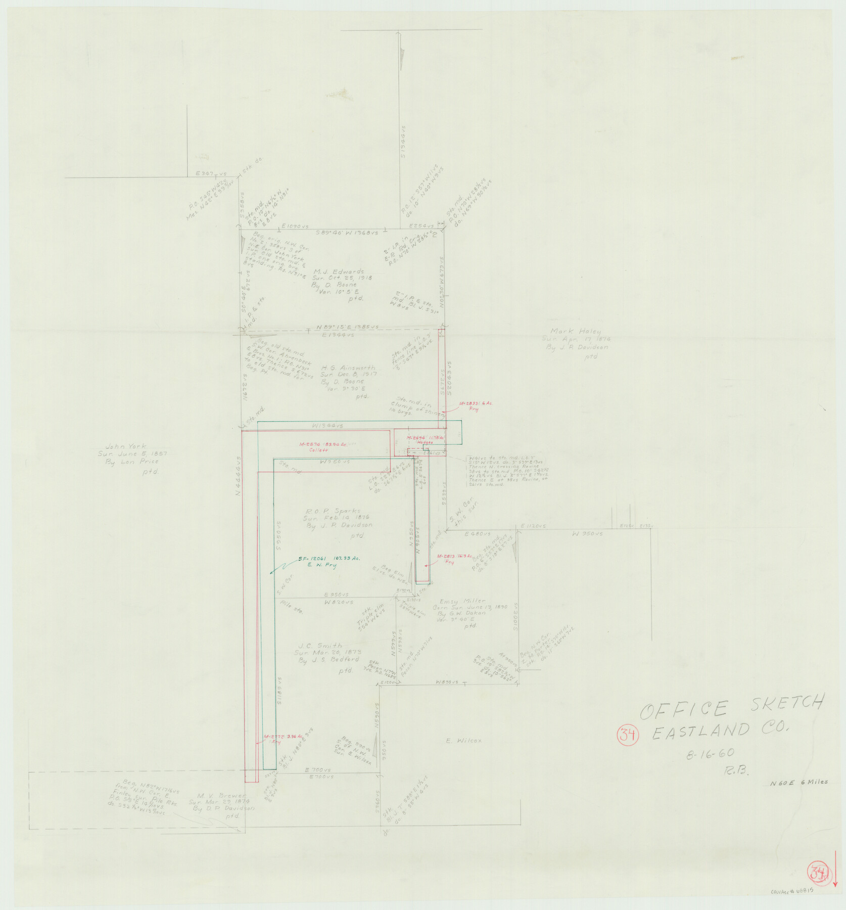
Eastland County Working Sketch 34
-
Map/Doc
68815
-
Collection
General Map Collection
-
Object Dates
8/16/1960 (Creation Date)
-
People and Organizations
Roy Buckholts (Draftsman)
-
Counties
Eastland
-
Subjects
Surveying Working Sketch
-
Height x Width
30.8 x 28.6 inches
78.2 x 72.6 cm
Part of: General Map Collection
Flight Mission No. DQO-1K, Frame 39, Galveston County

Print $20.00
- Digital $50.00
Flight Mission No. DQO-1K, Frame 39, Galveston County
1952
Size 18.8 x 22.6 inches
Map/Doc 84982
Hartley County

Print $40.00
- Digital $50.00
Hartley County
1925
Size 41.9 x 52.1 inches
Map/Doc 1851
Controlled Mosaic by Jack Amman Photogrammetric Engineers, Inc - Sheet 17

Print $20.00
- Digital $50.00
Controlled Mosaic by Jack Amman Photogrammetric Engineers, Inc - Sheet 17
1954
Size 20.0 x 24.0 inches
Map/Doc 83461
Zapata County Working Sketch 19

Print $40.00
- Digital $50.00
Zapata County Working Sketch 19
1976
Size 41.2 x 55.5 inches
Map/Doc 62070
Limestone County Working Sketch 18

Print $20.00
- Digital $50.00
Limestone County Working Sketch 18
1962
Size 45.5 x 38.7 inches
Map/Doc 70568
Kent County Sketch File 1

Print $6.00
- Digital $50.00
Kent County Sketch File 1
1882
Size 10.9 x 12.2 inches
Map/Doc 28823
Bailey County Rolled Sketch 2

Print $20.00
- Digital $50.00
Bailey County Rolled Sketch 2
1913
Size 26.8 x 21.4 inches
Map/Doc 5109
State of Texas

Print $40.00
- Digital $50.00
State of Texas
1965
Size 43.1 x 52.8 inches
Map/Doc 2488
Mason County Working Sketch 12

Print $20.00
- Digital $50.00
Mason County Working Sketch 12
1951
Size 28.1 x 23.6 inches
Map/Doc 70848
Flight Mission No. DAG-24K, Frame 39, Matagorda County

Print $20.00
- Digital $50.00
Flight Mission No. DAG-24K, Frame 39, Matagorda County
1953
Size 18.5 x 22.3 inches
Map/Doc 86526
Flight Mission No. BRE-2P, Frame 124, Nueces County

Print $20.00
- Digital $50.00
Flight Mission No. BRE-2P, Frame 124, Nueces County
1956
Size 18.3 x 22.3 inches
Map/Doc 86800
Current Miscellaneous File 44

Print $10.00
- Digital $50.00
Current Miscellaneous File 44
1954
Size 11.3 x 8.8 inches
Map/Doc 73985
You may also like
Uvalde County Rolled Sketch 11

Print $20.00
- Digital $50.00
Uvalde County Rolled Sketch 11
1966
Size 28.1 x 27.8 inches
Map/Doc 8096
Winkler County Working Sketch 13

Print $20.00
- Digital $50.00
Winkler County Working Sketch 13
1961
Size 39.2 x 41.2 inches
Map/Doc 72607
Randall County Working Sketch 3

Print $40.00
- Digital $50.00
Randall County Working Sketch 3
1934
Size 48.8 x 42.5 inches
Map/Doc 71840
Copy of Surveyor's Field Book, Morris Browning - In Blocks 7, 5 & 4, I&GNRRCo., Hutchinson and Carson Counties, Texas

Print $2.00
- Digital $50.00
Copy of Surveyor's Field Book, Morris Browning - In Blocks 7, 5 & 4, I&GNRRCo., Hutchinson and Carson Counties, Texas
1888
Size 6.9 x 8.8 inches
Map/Doc 62264
Aransas County Working Sketch 4

Print $20.00
- Digital $50.00
Aransas County Working Sketch 4
1928
Size 37.4 x 31.8 inches
Map/Doc 67171
[Maps of surveys in Reeves & Culberson Cos]
![61130, [Maps of surveys in Reeves & Culberson Cos], General Map Collection](https://historictexasmaps.com/wmedia_w700/maps/61130.tif.jpg)
Print $20.00
- Digital $50.00
[Maps of surveys in Reeves & Culberson Cos]
1937
Size 30.7 x 24.9 inches
Map/Doc 61130
Hale County Sketch File 11

Print $8.00
- Digital $50.00
Hale County Sketch File 11
1899
Size 11.1 x 8.5 inches
Map/Doc 24739
[Surveys in the Travis District along Onion Creek and the Pedernales River]
![40, [Surveys in the Travis District along Onion Creek and the Pedernales River], General Map Collection](https://historictexasmaps.com/wmedia_w700/maps/40.tif.jpg)
Print $20.00
- Digital $50.00
[Surveys in the Travis District along Onion Creek and the Pedernales River]
1841
Size 14.0 x 15.8 inches
Map/Doc 40
San Patricio County Sketch File 24

Print $10.00
San Patricio County Sketch File 24
1918
Size 10.0 x 4.3 inches
Map/Doc 36078
Map of Oceanica engraved to illustrate Mitchell's new intermediate geography

Print $20.00
- Digital $50.00
Map of Oceanica engraved to illustrate Mitchell's new intermediate geography
1885
Size 9.0 x 12.2 inches
Map/Doc 93531
County Map of the Pan-Handle of Texas and the line of the Texas Pan-Handle Route

Print $20.00
- Digital $50.00
County Map of the Pan-Handle of Texas and the line of the Texas Pan-Handle Route
1900
Size 7.2 x 10.3 inches
Map/Doc 95888
Upton County Working Sketch 1

Print $20.00
- Digital $50.00
Upton County Working Sketch 1
1906
Size 11.6 x 20.0 inches
Map/Doc 69497