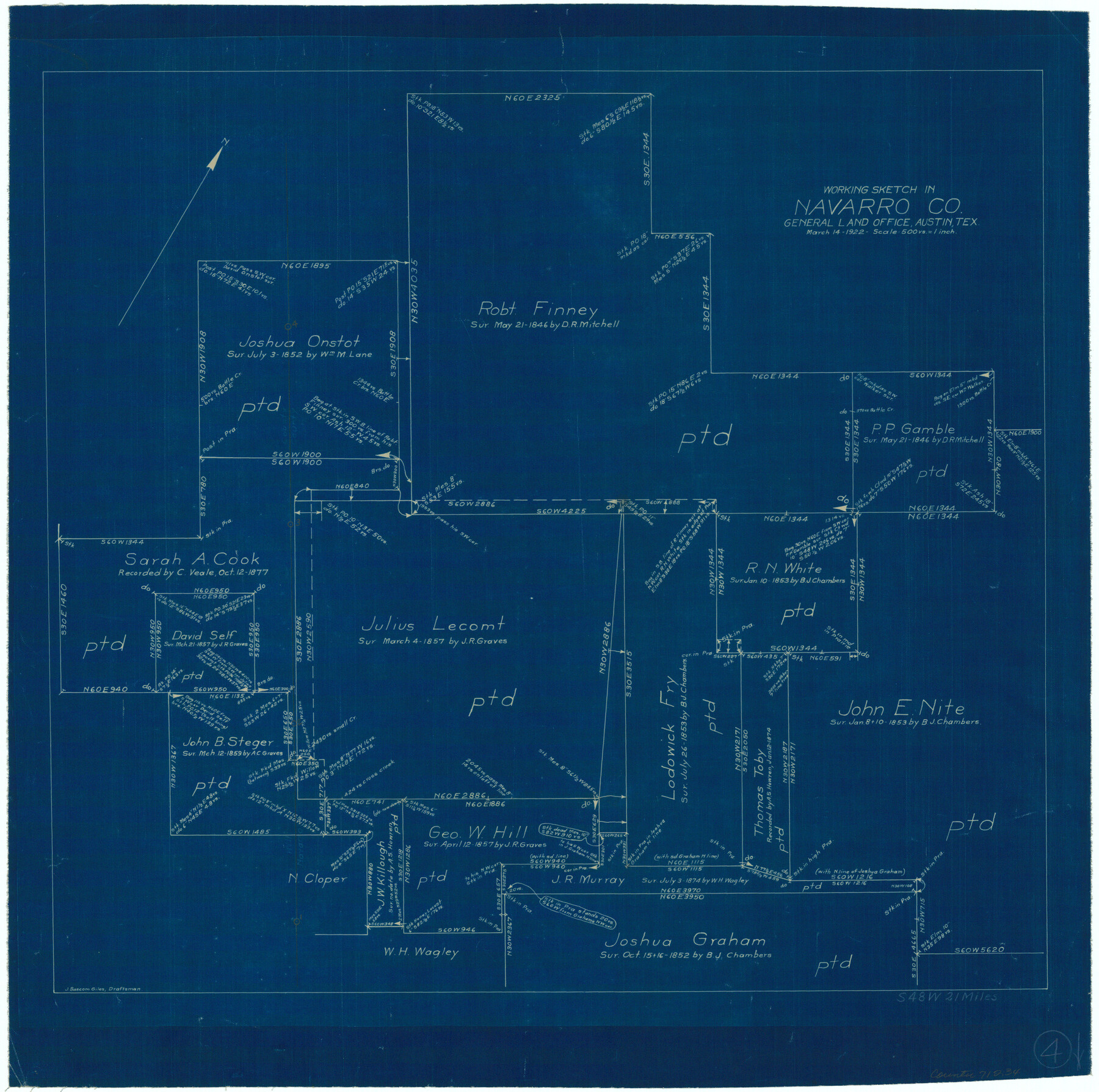
Navarro County Working Sketch 4
-
Map/Doc
71234
-
Collection
General Map Collection
-
Object Dates
3/14/1922 (Creation Date)
-
People and Organizations
J. Bascom Giles (Draftsman)
-
Counties
Navarro
-
Subjects
Surveying Working Sketch
-
Height x Width
20.8 x 20.9 inches
52.8 x 53.1 cm
-
Scale
1" = 500 varas
Part of: General Map Collection
Montague County Boundary File 2

Print $8.00
- Digital $50.00
Montague County Boundary File 2
Size 8.9 x 6.9 inches
Map/Doc 57406
Wharton County Sketch File 24

Print $20.00
- Digital $50.00
Wharton County Sketch File 24
1919
Size 19.9 x 25.5 inches
Map/Doc 12668
Presidio County Sketch File 71

Print $10.00
- Digital $50.00
Presidio County Sketch File 71
1942
Size 11.3 x 8.8 inches
Map/Doc 34674
Llano County Sketch File 14

Print $22.00
- Digital $50.00
Llano County Sketch File 14
Size 8.0 x 12.7 inches
Map/Doc 30389
San Saba County Sketch File 3

Print $4.00
- Digital $50.00
San Saba County Sketch File 3
1848
Size 12.5 x 7.9 inches
Map/Doc 36408
Flight Mission No. CRC-3R, Frame 32, Chambers County

Print $20.00
- Digital $50.00
Flight Mission No. CRC-3R, Frame 32, Chambers County
1956
Size 18.6 x 22.3 inches
Map/Doc 84805
Zavala County Rolled Sketch 22

Print $20.00
- Digital $50.00
Zavala County Rolled Sketch 22
Size 22.0 x 29.8 inches
Map/Doc 8325
Flight Mission No. DQN-1K, Frame 80, Calhoun County

Print $20.00
- Digital $50.00
Flight Mission No. DQN-1K, Frame 80, Calhoun County
1953
Size 18.4 x 22.1 inches
Map/Doc 84165
Smith County Working Sketch 9

Print $40.00
- Digital $50.00
Smith County Working Sketch 9
1947
Size 48.8 x 44.2 inches
Map/Doc 63894
[Beaumont, Sour Lake and Western Ry. Right of Way and Alignment - Frisco]
![64117, [Beaumont, Sour Lake and Western Ry. Right of Way and Alignment - Frisco], General Map Collection](https://historictexasmaps.com/wmedia_w700/maps/64117.tif.jpg)
Print $20.00
- Digital $50.00
[Beaumont, Sour Lake and Western Ry. Right of Way and Alignment - Frisco]
1910
Size 20.2 x 45.9 inches
Map/Doc 64117
Irion County Rolled Sketch 14

Print $20.00
- Digital $50.00
Irion County Rolled Sketch 14
1946
Size 25.3 x 21.9 inches
Map/Doc 6324
Hockley County

Print $20.00
- Digital $50.00
Hockley County
1914
Size 25.9 x 23.1 inches
Map/Doc 4980
You may also like
Navigation Maps of Gulf Intracoastal Waterway, Port Arthur to Brownsville, Texas

Print $4.00
- Digital $50.00
Navigation Maps of Gulf Intracoastal Waterway, Port Arthur to Brownsville, Texas
1951
Size 16.8 x 21.3 inches
Map/Doc 65450
Karte des Staates, Texas

Print $20.00
- Digital $50.00
Karte des Staates, Texas
1851
Size 17.8 x 19.9 inches
Map/Doc 97191
Polk County Working Sketch 32

Print $20.00
- Digital $50.00
Polk County Working Sketch 32
1960
Size 28.8 x 37.3 inches
Map/Doc 71648
Red River County Sketch File 17b

Print $4.00
- Digital $50.00
Red River County Sketch File 17b
1875
Size 12.9 x 8.1 inches
Map/Doc 35147
Newton County Rolled Sketch 25

Print $20.00
- Digital $50.00
Newton County Rolled Sketch 25
1893
Size 22.4 x 18.7 inches
Map/Doc 6853
Anderson County Sketch File 25

Print $40.00
- Digital $50.00
Anderson County Sketch File 25
1969
Size 40.9 x 21.9 inches
Map/Doc 10316
Jeff Davis County Sketch File 43

Print $10.00
- Digital $50.00
Jeff Davis County Sketch File 43
1970
Size 14.2 x 8.6 inches
Map/Doc 28066
Jasper County Sketch File 12

Print $4.00
- Digital $50.00
Jasper County Sketch File 12
Size 8.8 x 10.0 inches
Map/Doc 27792
English Field Notes of the Spanish Archives - Book 7

English Field Notes of the Spanish Archives - Book 7
1835
Map/Doc 96533
Lubbock County Sketch File 11

Print $22.00
- Digital $50.00
Lubbock County Sketch File 11
1914
Size 11.2 x 8.8 inches
Map/Doc 30434
Hardeman County

Print $20.00
- Digital $50.00
Hardeman County
1876
Size 24.1 x 31.5 inches
Map/Doc 3625
Fisher County Working Sketch 1

Print $20.00
- Digital $50.00
Fisher County Working Sketch 1
1911
Size 37.6 x 26.4 inches
Map/Doc 69135