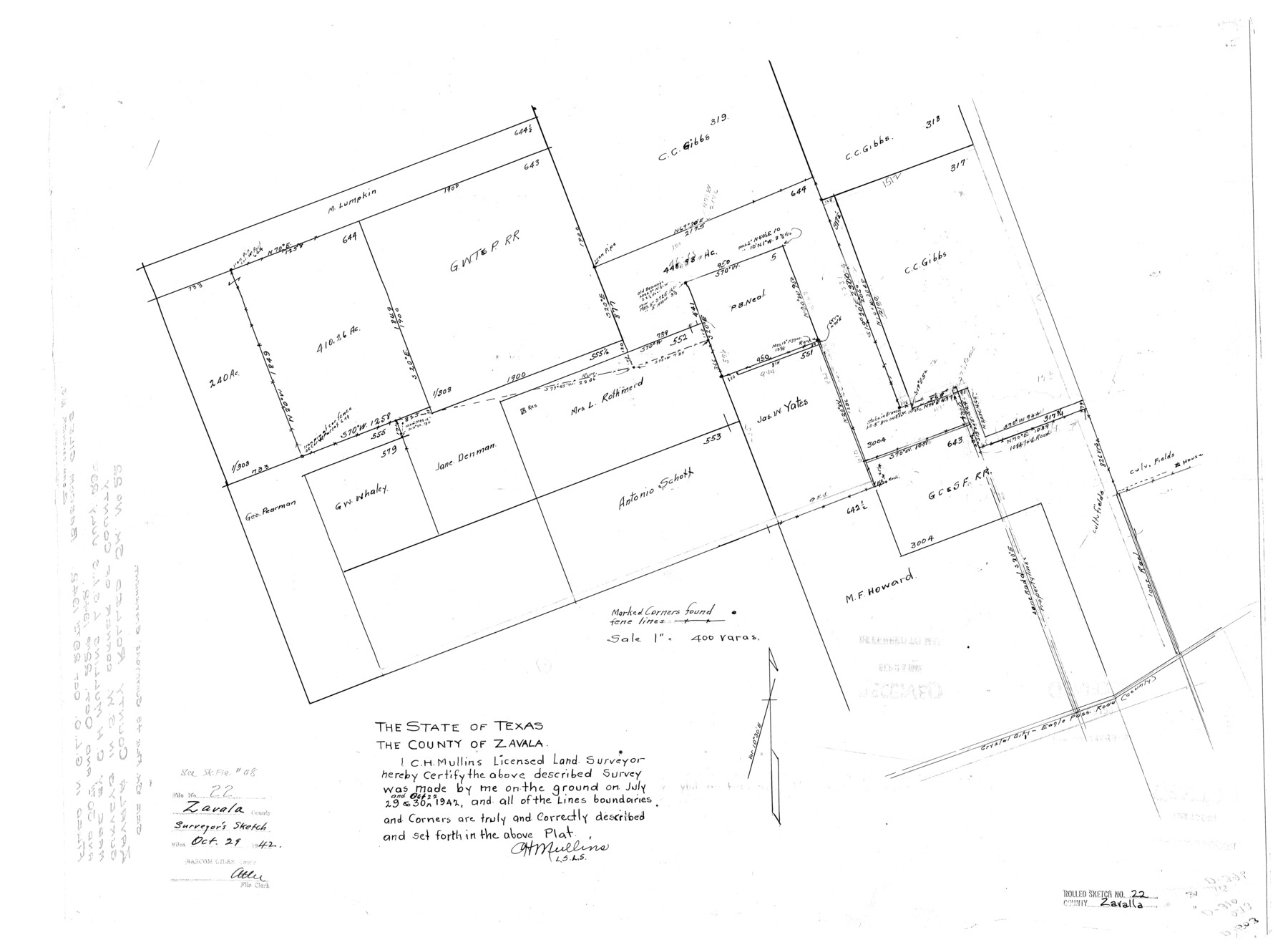
Zavala County Rolled Sketch 22
[Sketch of surveys in the southwest corner of Zavala County]
-
Map/Doc
8325
-
Collection
General Map Collection
-
Object Dates
1942/10/22 (Survey Date)
1942/10/29 (File Date)
-
People and Organizations
C.H. Mullins (Surveyor/Engineer)
-
Counties
Zavala
-
Subjects
Surveying Rolled Sketch
-
Height x Width
22.0 x 29.8 inches
55.9 x 75.7 cm
-
Scale
1" = 400 varas
-
Comments
See Zavala County Sketch File 48 (41438) for report.
Related maps
Zavala County Sketch File 48

Print $6.00
- Digital $50.00
Zavala County Sketch File 48
1942
Size 11.4 x 9.0 inches
Map/Doc 41438
Part of: General Map Collection
Rusk County Sketch File 9

Print $4.00
Rusk County Sketch File 9
1849
Size 8.4 x 8.2 inches
Map/Doc 35505
Jefferson County NRC Article 33.136 Sketch 5

Print $4.00
- Digital $50.00
Jefferson County NRC Article 33.136 Sketch 5
2005
Size 14.1 x 8.8 inches
Map/Doc 83170
Jackson County Sketch File A2 (1)

Print $20.00
- Digital $50.00
Jackson County Sketch File A2 (1)
1899
Size 18.2 x 22.5 inches
Map/Doc 11848
Dimmit County Rolled Sketch 20

Print $20.00
- Digital $50.00
Dimmit County Rolled Sketch 20
1999
Size 24.6 x 36.6 inches
Map/Doc 5726
Val Verde County Working Sketch 96

Print $20.00
- Digital $50.00
Val Verde County Working Sketch 96
1979
Size 38.9 x 36.9 inches
Map/Doc 72231
Harris County Rolled Sketch 86

Print $20.00
- Digital $50.00
Harris County Rolled Sketch 86
1947
Size 38.3 x 34.1 inches
Map/Doc 73577
Webb County Boundary File 1a

Print $50.00
- Digital $50.00
Webb County Boundary File 1a
Size 14.3 x 9.0 inches
Map/Doc 59703
Pecos County Working Sketch 43

Print $40.00
- Digital $50.00
Pecos County Working Sketch 43
1943
Size 19.5 x 50.7 inches
Map/Doc 71515
Blanco County Rolled Sketch 17

Print $20.00
- Digital $50.00
Blanco County Rolled Sketch 17
Size 18.0 x 23.9 inches
Map/Doc 5153
Concho County Sketch File 23

Print $6.00
- Digital $50.00
Concho County Sketch File 23
Size 11.0 x 7.3 inches
Map/Doc 19146
Railroad Track Map, T&PRRCo., Culberson County, Texas

Print $4.00
- Digital $50.00
Railroad Track Map, T&PRRCo., Culberson County, Texas
1910
Size 11.7 x 18.5 inches
Map/Doc 62825
Henderson County Working Sketch 41

Print $20.00
- Digital $50.00
Henderson County Working Sketch 41
1985
Size 28.8 x 17.0 inches
Map/Doc 66174
You may also like
Comanche County Working Sketch 9

Print $20.00
- Digital $50.00
Comanche County Working Sketch 9
1954
Size 18.6 x 21.5 inches
Map/Doc 68143
Rockwall County Sketch File 1

Print $22.00
Rockwall County Sketch File 1
Size 14.5 x 16.1 inches
Map/Doc 35413
Frio County Sketch File 19

Print $20.00
- Digital $50.00
Frio County Sketch File 19
1963
Size 14.7 x 30.6 inches
Map/Doc 11519
Starr County Sketch File 8

Print $7.00
- Digital $50.00
Starr County Sketch File 8
Size 10.1 x 12.4 inches
Map/Doc 36858
Map of Crockett County

Print $40.00
- Digital $50.00
Map of Crockett County
1878
Size 60.2 x 97.2 inches
Map/Doc 78701
[Surveys along the San Gabriel River]
![78375, [Surveys along the San Gabriel River], General Map Collection](https://historictexasmaps.com/wmedia_w700/maps/78375.tif.jpg)
Print $2.00
- Digital $50.00
[Surveys along the San Gabriel River]
Size 9.0 x 6.3 inches
Map/Doc 78375
Sterling County Rolled Sketch 10

Print $20.00
- Digital $50.00
Sterling County Rolled Sketch 10
1939
Size 24.2 x 31.2 inches
Map/Doc 7846
Flight Mission No. CRC-2R, Frame 196, Chambers County

Print $20.00
- Digital $50.00
Flight Mission No. CRC-2R, Frame 196, Chambers County
1956
Size 18.7 x 22.4 inches
Map/Doc 84774
Preliminary Chart No. 31 of the Sea Coast of the United States from Galveston Bay to Matagorda Bay, Texas

Print $20.00
- Digital $50.00
Preliminary Chart No. 31 of the Sea Coast of the United States from Galveston Bay to Matagorda Bay, Texas
1857
Size 23.3 x 28.1 inches
Map/Doc 69950
Panola County Sketch File 21

Print $10.00
- Digital $50.00
Panola County Sketch File 21
Size 11.2 x 8.7 inches
Map/Doc 33487
Brewster County Rolled Sketch 45

Print $20.00
- Digital $50.00
Brewster County Rolled Sketch 45
1921
Size 20.3 x 15.6 inches
Map/Doc 5221
[Sketches on Lagoona (sic) Creek, Attascosa (sic) and Laredo Road]
![126, [Sketches on Lagoona (sic) Creek, Attascosa (sic) and Laredo Road], General Map Collection](https://historictexasmaps.com/wmedia_w700/maps/126.tif.jpg)
Print $20.00
- Digital $50.00
[Sketches on Lagoona (sic) Creek, Attascosa (sic) and Laredo Road]
1841
Size 18.0 x 13.5 inches
Map/Doc 126