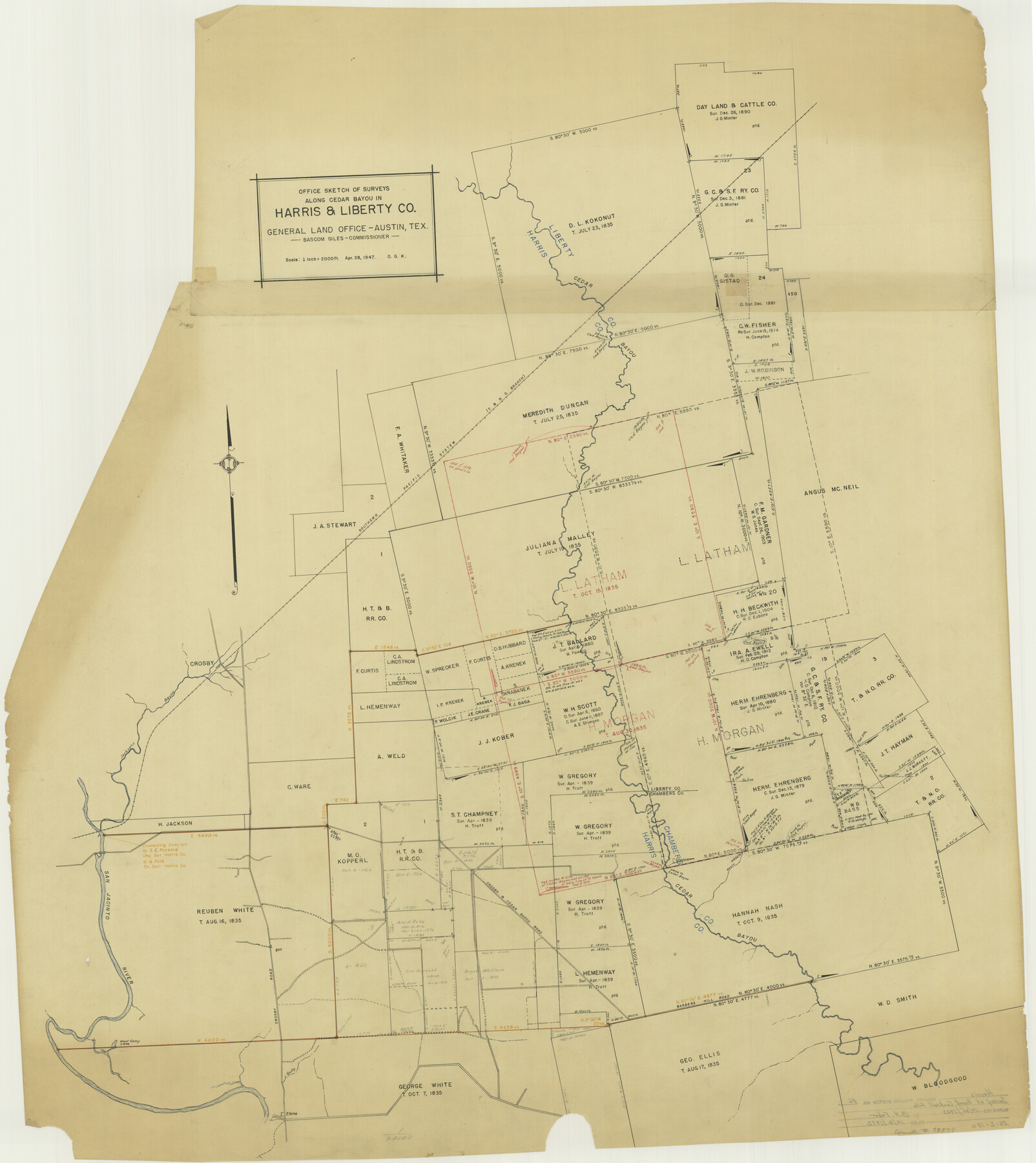
Harris County Rolled Sketch 86
Office Sketch of surveys along Cedar Bayou in Harris & Liberty Co.
-
Map/Doc
73577
-
Collection
General Map Collection
-
Object Dates
1947/4/28 (Creation Date)
-
Counties
Harris Liberty Chambers
-
Subjects
Surveying Rolled Sketch
-
Height x Width
38.3 x 34.1 inches
97.3 x 86.6 cm
-
Medium
paper, manuscript
-
Scale
1" = 2000 feet
Part of: General Map Collection
Nueces County Rolled Sketch 79A

Print $20.00
- Digital $50.00
Nueces County Rolled Sketch 79A
1966
Size 17.7 x 25.7 inches
Map/Doc 9628
Baylor County Sketch File 12h

Print $49.00
- Digital $50.00
Baylor County Sketch File 12h
Size 9.3 x 14.7 inches
Map/Doc 14175
Palo Pinto County Boundary File 4b

Print $38.00
- Digital $50.00
Palo Pinto County Boundary File 4b
Size 13.6 x 8.6 inches
Map/Doc 57824
Jack County Sketch File 33

Print $20.00
- Digital $50.00
Jack County Sketch File 33
Size 19.5 x 21.4 inches
Map/Doc 11831
Nacogdoches County Sketch File 2

Print $4.00
- Digital $50.00
Nacogdoches County Sketch File 2
1852
Size 8.0 x 6.4 inches
Map/Doc 32235
Lavaca County Rolled Sketch 8

Print $40.00
- Digital $50.00
Lavaca County Rolled Sketch 8
1982
Size 36.5 x 65.6 inches
Map/Doc 10289
Presidio County Sketch File 33

Print $16.00
- Digital $50.00
Presidio County Sketch File 33
1890
Size 14.5 x 8.8 inches
Map/Doc 34476
Atascosa County Working Sketch 32

Print $20.00
- Digital $50.00
Atascosa County Working Sketch 32
1981
Size 12.9 x 11.8 inches
Map/Doc 67228
Trinity County Working Sketch 24

Print $20.00
- Digital $50.00
Trinity County Working Sketch 24
2010
Size 18.2 x 36.5 inches
Map/Doc 89599
San Patricio County Rolled Sketch 49

Print $20.00
- Digital $50.00
San Patricio County Rolled Sketch 49
1979
Size 21.2 x 20.3 inches
Map/Doc 7735
Hays County Working Sketch 11

Print $20.00
- Digital $50.00
Hays County Working Sketch 11
1950
Size 22.7 x 33.1 inches
Map/Doc 66085
Bowie County Sketch File 9

Print $10.00
- Digital $50.00
Bowie County Sketch File 9
Size 8.1 x 3.9 inches
Map/Doc 14907
You may also like
Wilbarger Co.

Print $40.00
- Digital $50.00
Wilbarger Co.
1889
Size 48.8 x 38.4 inches
Map/Doc 63125
Limestone County Working Sketch 26

Print $20.00
- Digital $50.00
Limestone County Working Sketch 26
1982
Size 39.6 x 44.1 inches
Map/Doc 70576
Dimmit County Sketch File 12

Print $104.00
- Digital $50.00
Dimmit County Sketch File 12
1883
Size 31.9 x 33.6 inches
Map/Doc 10366
Crockett County Working Sketch 66

Print $40.00
- Digital $50.00
Crockett County Working Sketch 66
1959
Size 62.7 x 44.0 inches
Map/Doc 68399
Freestone County Rolled Sketch 13B

Print $20.00
- Digital $50.00
Freestone County Rolled Sketch 13B
1989
Size 25.2 x 20.5 inches
Map/Doc 5915
Cottle County Working Sketch 23

Print $20.00
- Digital $50.00
Cottle County Working Sketch 23
1992
Size 26.6 x 24.2 inches
Map/Doc 68333
Brooks County Sketch File 4

Print $4.00
- Digital $50.00
Brooks County Sketch File 4
Size 14.3 x 8.7 inches
Map/Doc 16549
[East Line and Red River Railroad Company, Block Z and vicinity]
![91256, [East Line and Red River Railroad Company, Block Z and vicinity], Twichell Survey Records](https://historictexasmaps.com/wmedia_w700/maps/91256-1.tif.jpg)
Print $20.00
- Digital $50.00
[East Line and Red River Railroad Company, Block Z and vicinity]
1878
Size 27.8 x 22.1 inches
Map/Doc 91256
The Range and Ranch Cattle Area of the United States

Print $20.00
- Digital $50.00
The Range and Ranch Cattle Area of the United States
1884
Size 26.4 x 27.2 inches
Map/Doc 94077
Sabine County

Print $20.00
- Digital $50.00
Sabine County
1920
Size 44.6 x 35.1 inches
Map/Doc 16805
Kimble County Working Sketch 22

Print $20.00
- Digital $50.00
Kimble County Working Sketch 22
1929
Size 25.2 x 21.1 inches
Map/Doc 70090
Fannin County Boundary File 3

Print $36.00
- Digital $50.00
Fannin County Boundary File 3
Size 13.2 x 8.8 inches
Map/Doc 53295