Webb County Rolled Sketch 71
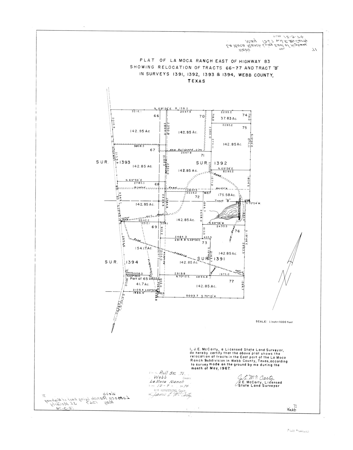
Plat of La Moca Ranch east of Highway 83 showing relocation of tracts 66, 77, and tract "B" in surveys 1391, 1392, 1393, & 1394, Webb County, Texas
-
Map/Doc
8219
-
Collection
General Map Collection
-
Object Dates
1967 (Creation Date)
1974/12/9 (File Date)
-
People and Organizations
J.E. McCarty (Surveyor/Engineer)
-
Counties
Webb
-
Subjects
Surveying Rolled Sketch
-
Height x Width
26.2 x 20.5 inches
66.5 x 52.1 cm
-
Medium
mylar, print
-
Scale
1" = 1000 feet
Part of: General Map Collection
Kaufman County Working Sketch 6

Print $20.00
- Digital $50.00
Kaufman County Working Sketch 6
1937
Size 22.4 x 27.9 inches
Map/Doc 66669
Foard County Working Sketch 14

Print $20.00
- Digital $50.00
Foard County Working Sketch 14
1982
Size 37.6 x 46.9 inches
Map/Doc 69205
Ellis County Sketch File 20

Print $19.00
- Digital $50.00
Ellis County Sketch File 20
1869
Size 12.8 x 8.2 inches
Map/Doc 21869
Guadalupe County Sketch File 7c

Print $22.00
- Digital $50.00
Guadalupe County Sketch File 7c
Size 12.7 x 15.5 inches
Map/Doc 24672
Reeves County Working Sketch 50

Print $20.00
- Digital $50.00
Reeves County Working Sketch 50
1974
Size 45.3 x 30.4 inches
Map/Doc 63493
Anderson County Sketch File 11a

Print $6.00
- Digital $50.00
Anderson County Sketch File 11a
1854
Size 8.2 x 8.2 inches
Map/Doc 12768
Bandera County Working Sketch 12

Print $20.00
- Digital $50.00
Bandera County Working Sketch 12
Size 34.0 x 36.9 inches
Map/Doc 67605
[Surveys along the Pedernales River and Cypress Creek]
![121, [Surveys along the Pedernales River and Cypress Creek], General Map Collection](https://historictexasmaps.com/wmedia_w700/maps/121.tif.jpg)
Print $2.00
- Digital $50.00
[Surveys along the Pedernales River and Cypress Creek]
1841
Size 8.3 x 7.7 inches
Map/Doc 121
Bandera County Working Sketch 33

Print $20.00
- Digital $50.00
Bandera County Working Sketch 33
1961
Size 22.4 x 28.8 inches
Map/Doc 67629
San Patricio County Rolled Sketch 46G

Print $40.00
- Digital $50.00
San Patricio County Rolled Sketch 46G
1983
Size 31.2 x 50.0 inches
Map/Doc 8378
Gillespie County Boundary File 5

Print $10.00
- Digital $50.00
Gillespie County Boundary File 5
Size 14.2 x 9.0 inches
Map/Doc 53764
El Paso County Rolled Sketch 52

Print $20.00
- Digital $50.00
El Paso County Rolled Sketch 52
1929
Size 18.5 x 24.4 inches
Map/Doc 5848
You may also like
Map of the Republic of Texas showing its division into counties and latest improvements too

Print $20.00
- Digital $50.00
Map of the Republic of Texas showing its division into counties and latest improvements too
1837
Size 12.3 x 9.6 inches
Map/Doc 76874
Val Verde County Working Sketch 22

Print $20.00
- Digital $50.00
Val Verde County Working Sketch 22
1931
Size 27.6 x 33.0 inches
Map/Doc 72157
Refugio County Sketch File 27

Print $18.00
- Digital $50.00
Refugio County Sketch File 27
1993
Size 11.4 x 8.8 inches
Map/Doc 35294
Cooke County Working Sketch 18

Print $20.00
- Digital $50.00
Cooke County Working Sketch 18
1952
Size 23.5 x 19.6 inches
Map/Doc 68255
Gaines County

Print $20.00
- Digital $50.00
Gaines County
1956
Size 32.2 x 40.6 inches
Map/Doc 77286
DeWitt County Sketch File 13

Print $8.00
- Digital $50.00
DeWitt County Sketch File 13
1845
Size 12.8 x 8.2 inches
Map/Doc 20824
Hopkins County Sketch File 26

Print $4.00
- Digital $50.00
Hopkins County Sketch File 26
Size 8.4 x 6.1 inches
Map/Doc 26736
Red River, Bois D'Arc Creek Floodway Sheet No. 7

Print $20.00
- Digital $50.00
Red River, Bois D'Arc Creek Floodway Sheet No. 7
1917
Size 29.0 x 23.8 inches
Map/Doc 69662
Runnels County Boundary File 2a

Print $8.00
- Digital $50.00
Runnels County Boundary File 2a
Size 11.5 x 8.8 inches
Map/Doc 58526
Presidio County Sketch File 6

Print $20.00
- Digital $50.00
Presidio County Sketch File 6
Size 21.3 x 17.8 inches
Map/Doc 11705
Flight Mission No. DAG-23K, Frame 12, Matagorda County

Print $20.00
- Digital $50.00
Flight Mission No. DAG-23K, Frame 12, Matagorda County
1953
Size 15.5 x 15.5 inches
Map/Doc 86474
History of Texas from its First Settlement in 1685 to its Annexation to the United States in 1846 (Vol. 2)

History of Texas from its First Settlement in 1685 to its Annexation to the United States in 1846 (Vol. 2)
1856
Map/Doc 97391