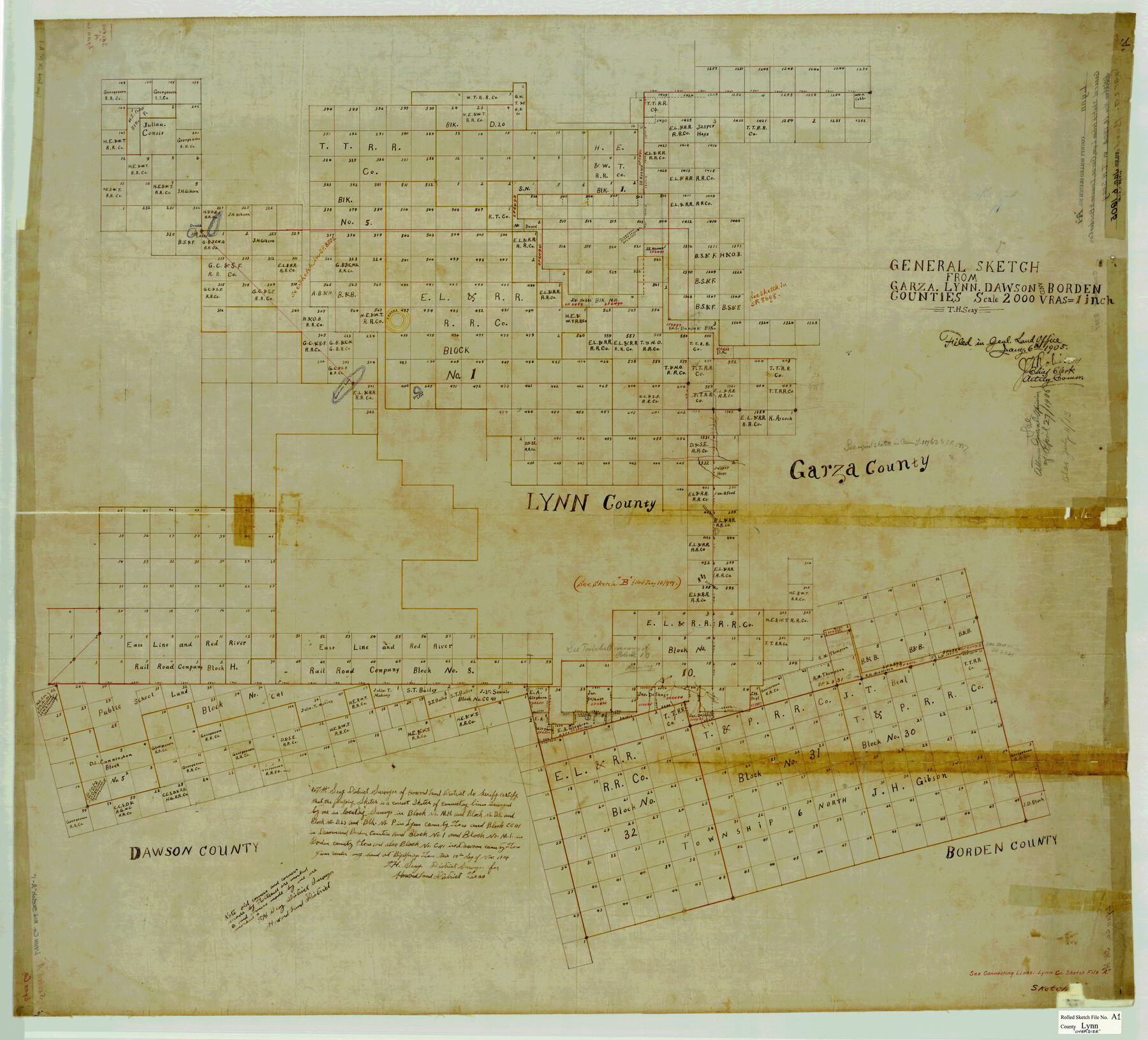
Lynn County Rolled Sketch A1
General sketch from Garza, Lynn, Dawson and Borden Counties
-
Map/Doc
8347
-
Collection
General Map Collection
-
Object Dates
1904/11/14 (Creation Date)
1905/1/6 (File Date)
-
People and Organizations
T.H. Seay (Surveyor/Engineer)
-
Counties
Lynn Garza Dawson Borden
-
Subjects
Surveying Rolled Sketch
-
Height x Width
39.2 x 43.3 inches
99.6 x 110.0 cm
-
Medium
linen, manuscript
-
Scale
1" = 2000 varas
-
Comments
See Lynn County Sketch File A (30477) for jacket, Lynn County Sketch Files A1 (30464), A2 (30470), and A3 (30473) for field notes, and Lynn County Rolled Sketch B (6653) for additional sketch.
Related maps
Lynn County Sketch File A1

Print $12.00
- Digital $50.00
Lynn County Sketch File A1
1903
Size 12.7 x 8.2 inches
Map/Doc 30464
Lynn County Sketch File A2

Print $6.00
- Digital $50.00
Lynn County Sketch File A2
1903
Size 12.7 x 8.0 inches
Map/Doc 30470
Lynn County Sketch File A3

Print $4.00
- Digital $50.00
Lynn County Sketch File A3
1904
Size 12.7 x 8.0 inches
Map/Doc 30473
Lynn County Sketch File A

Print $2.00
- Digital $50.00
Lynn County Sketch File A
1905
Size 8.6 x 6.3 inches
Map/Doc 30477
Lynn County Rolled Sketch B

Print $20.00
- Digital $50.00
Lynn County Rolled Sketch B
1908
Size 27.9 x 33.1 inches
Map/Doc 6653
Part of: General Map Collection
Henderson County Sketch File 12

Print $8.00
- Digital $50.00
Henderson County Sketch File 12
1871
Size 8.4 x 7.4 inches
Map/Doc 26349
Map Showing Survey of Navasota River Bed in Limestone County Texas Located North of Houston and Texas Central Railroad Bridge

Print $40.00
- Digital $50.00
Map Showing Survey of Navasota River Bed in Limestone County Texas Located North of Houston and Texas Central Railroad Bridge
1921
Size 68.0 x 42.5 inches
Map/Doc 65347
Aransas County Boundary File 3

Print $16.00
- Digital $50.00
Aransas County Boundary File 3
Size 10.6 x 8.0 inches
Map/Doc 49782
[Surveys along the Trinity River]
![298, [Surveys along the Trinity River], General Map Collection](https://historictexasmaps.com/wmedia_w700/maps/298.tif.jpg)
Print $2.00
- Digital $50.00
[Surveys along the Trinity River]
Size 6.3 x 9.2 inches
Map/Doc 298
[G.C. and S. F. R.R. Co. Through Bosque County from McLennan Co. and E. to Hill Co. Station M. P. 259 to M. P. 297]
![64563, [G.C. and S. F. R.R. Co. Through Bosque County from McLennan Co. and E. to Hill Co. Station M. P. 259 to M. P. 297], General Map Collection](https://historictexasmaps.com/wmedia_w700/maps/64563-1.tif.jpg)
Print $40.00
- Digital $50.00
[G.C. and S. F. R.R. Co. Through Bosque County from McLennan Co. and E. to Hill Co. Station M. P. 259 to M. P. 297]
Size 21.7 x 120.5 inches
Map/Doc 64563
Flight Mission No. DQN-1K, Frame 129, Calhoun County

Print $20.00
- Digital $50.00
Flight Mission No. DQN-1K, Frame 129, Calhoun County
1953
Size 18.5 x 22.2 inches
Map/Doc 84192
Reagan County Working Sketch 18

Print $20.00
- Digital $50.00
Reagan County Working Sketch 18
1954
Size 23.6 x 42.9 inches
Map/Doc 71860

Denton County Working Sketch 32

Print $20.00
- Digital $50.00
Denton County Working Sketch 32
Size 35.1 x 32.0 inches
Map/Doc 68637
Montgomery County Sketch File 19

Print $24.00
- Digital $50.00
Montgomery County Sketch File 19
1931
Size 9.0 x 7.0 inches
Map/Doc 31835
Crockett County Rolled Sketch 71

Print $40.00
- Digital $50.00
Crockett County Rolled Sketch 71
1949
Size 54.5 x 38.9 inches
Map/Doc 8722
Concho County Sketch File 37

Print $20.00
- Digital $50.00
Concho County Sketch File 37
1938
Size 18.7 x 29.1 inches
Map/Doc 11162
You may also like
Flight Mission No. DQO-1K, Frame 153, Galveston County

Print $20.00
- Digital $50.00
Flight Mission No. DQO-1K, Frame 153, Galveston County
1952
Size 18.8 x 22.5 inches
Map/Doc 85006
Atascosa County Working Sketch 27

Print $20.00
- Digital $50.00
Atascosa County Working Sketch 27
1963
Size 16.8 x 18.6 inches
Map/Doc 67223
[Capitol Leagues 217, 218, 219 and 220]
![91460, [Capitol Leagues 217, 218, 219 and 220], Twichell Survey Records](https://historictexasmaps.com/wmedia_w700/maps/91460-1.tif.jpg)
Print $20.00
- Digital $50.00
[Capitol Leagues 217, 218, 219 and 220]
Size 23.2 x 10.3 inches
Map/Doc 91460
Presidio County Working Sketch 100

Print $20.00
- Digital $50.00
Presidio County Working Sketch 100
1979
Size 45.7 x 34.5 inches
Map/Doc 71777
Capitol Complex, Austin, Texas

Print $20.00
- Digital $50.00
Capitol Complex, Austin, Texas
1974
Size 42.7 x 30.6 inches
Map/Doc 94241
Jefferson County Working Sketch 35

Print $20.00
- Digital $50.00
Jefferson County Working Sketch 35
1982
Size 39.1 x 32.6 inches
Map/Doc 66579
Briscoe County Sketch File 2a

Print $4.00
- Digital $50.00
Briscoe County Sketch File 2a
Size 6.2 x 7.1 inches
Map/Doc 16415

Dawson County Sketch File 15

Print $40.00
- Digital $50.00
Dawson County Sketch File 15
Size 17.8 x 7.9 inches
Map/Doc 20549
Travis County Appraisal District Plat Map 2_2003

Print $20.00
- Digital $50.00
Travis County Appraisal District Plat Map 2_2003
Size 21.6 x 26.5 inches
Map/Doc 94202
The Republic County of Refugio. December 2, 1841

Print $20.00
The Republic County of Refugio. December 2, 1841
2020
Size 22.3 x 21.6 inches
Map/Doc 96257
Hidalgo County Rolled Sketch 17

Print $40.00
- Digital $50.00
Hidalgo County Rolled Sketch 17
1963
Size 68.4 x 42.9 inches
Map/Doc 9172