Aransas County Rolled Sketch 20
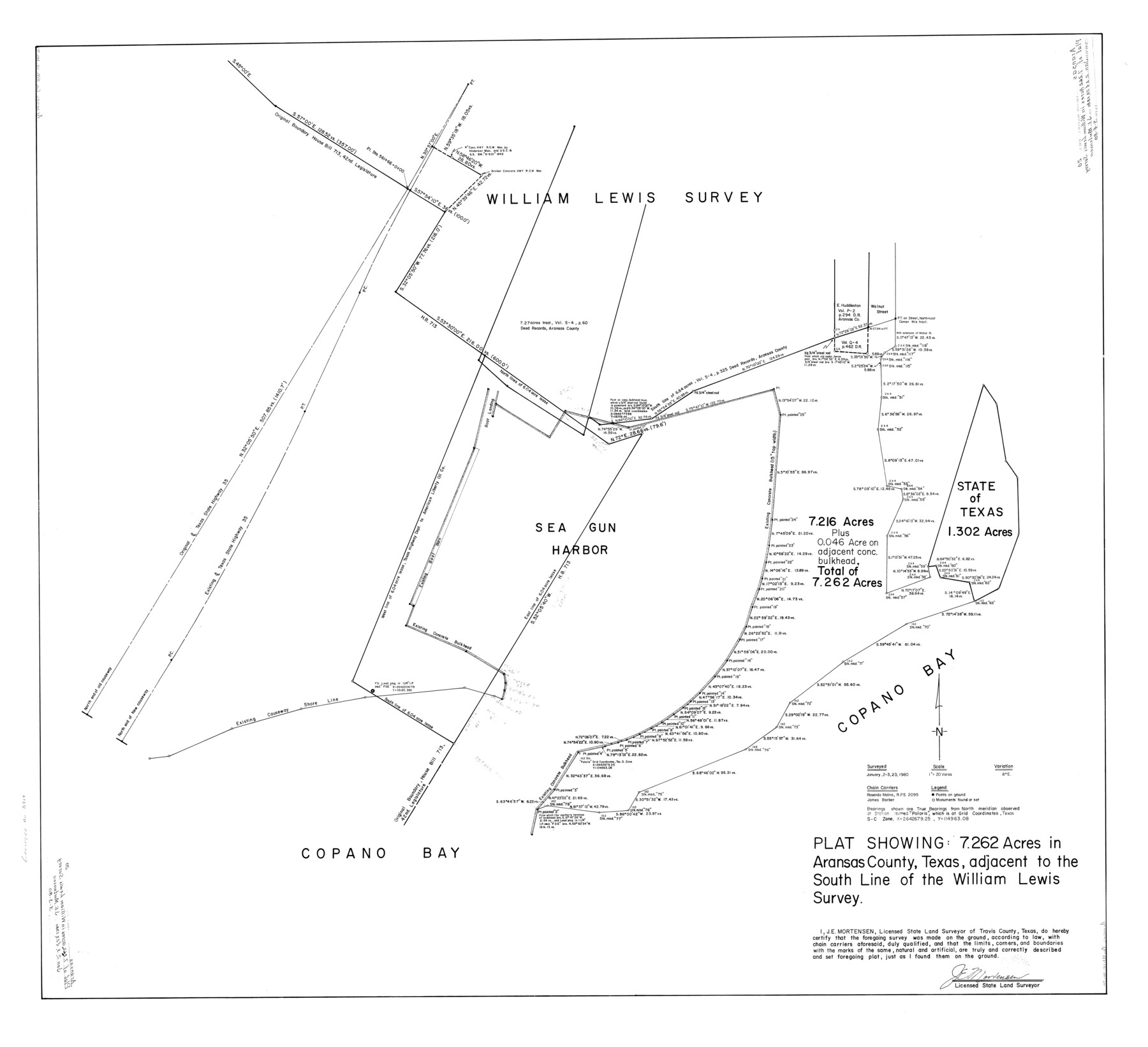
Plat showing: 7.262 acres in Aransas County, Texas, adjacent to the south line of the William Lewis survey
-
Map/Doc
8414
-
Collection
General Map Collection
-
Object Dates
1980/1/2 (Survey Date)
1980/1/23 (Survey Date)
1980/3/4 (File Date)
1980/1/3 (Survey Date)
-
People and Organizations
James E. Mortensen (Surveyor/Engineer)
James Barber (Chainman/Field Personnel)
Rosendo V. Molina (Surveyor/Engineer)
-
Counties
Aransas
-
Subjects
Surveying Rolled Sketch
-
Height x Width
43.2 x 47.3 inches
109.7 x 120.1 cm
-
Medium
linen, manuscript
-
Scale
1" = 20 varas
Part of: General Map Collection
[Surveys near the Sabine River in the Jasper District]
![323, [Surveys near the Sabine River in the Jasper District], General Map Collection](https://historictexasmaps.com/wmedia_w700/maps/323.tif.jpg)
Print $20.00
- Digital $50.00
[Surveys near the Sabine River in the Jasper District]
1847
Size 18.1 x 10.4 inches
Map/Doc 323
Bailey County Sketch File 14

Print $4.00
- Digital $50.00
Bailey County Sketch File 14
Size 12.2 x 8.7 inches
Map/Doc 13973
Galveston County Sketch File 26

Print $4.00
- Digital $50.00
Galveston County Sketch File 26
1860
Size 11.8 x 5.7 inches
Map/Doc 23397
Uvalde County Working Sketch 14

Print $20.00
- Digital $50.00
Uvalde County Working Sketch 14
1943
Size 13.5 x 16.0 inches
Map/Doc 72084
Brewster County Working Sketch 93

Print $40.00
- Digital $50.00
Brewster County Working Sketch 93
1975
Size 60.6 x 39.9 inches
Map/Doc 67693
Nacogdoches County Working Sketch 3

Print $20.00
- Digital $50.00
Nacogdoches County Working Sketch 3
1935
Size 30.0 x 39.4 inches
Map/Doc 71219
Crosby County Sketch File 22

Print $22.00
- Digital $50.00
Crosby County Sketch File 22
1912
Size 11.3 x 8.6 inches
Map/Doc 20090
Val Verde County Rolled Sketch 79

Print $20.00
- Digital $50.00
Val Verde County Rolled Sketch 79
1983
Size 25.6 x 21.7 inches
Map/Doc 8141
Collin County Boundary File 18 and 18a

Print $8.00
- Digital $50.00
Collin County Boundary File 18 and 18a
Size 7.8 x 4.0 inches
Map/Doc 51717
Cameron County Rolled Sketch US

Print $20.00
- Digital $50.00
Cameron County Rolled Sketch US
1913
Size 31.1 x 26.3 inches
Map/Doc 5398
Roberts County Rolled Sketch 7

Print $20.00
- Digital $50.00
Roberts County Rolled Sketch 7
2018
Size 20.1 x 24.1 inches
Map/Doc 97418
Runnels County Working Sketch 27

Print $20.00
- Digital $50.00
Runnels County Working Sketch 27
1957
Size 27.1 x 22.1 inches
Map/Doc 63623
You may also like
Concho County Working Sketch 10

Print $20.00
- Digital $50.00
Concho County Working Sketch 10
1951
Size 21.2 x 15.6 inches
Map/Doc 68192
Matagorda County NRC Article 33.136 Sketch 3

Print $20.00
- Digital $50.00
Matagorda County NRC Article 33.136 Sketch 3
2008
Size 36.0 x 24.0 inches
Map/Doc 88834
Maverick County Sketch File 14

Print $4.00
- Digital $50.00
Maverick County Sketch File 14
1883
Size 11.1 x 8.5 inches
Map/Doc 31111
Amistad International Reservoir on Rio Grande 79

Print $20.00
- Digital $50.00
Amistad International Reservoir on Rio Grande 79
1949
Size 28.6 x 40.3 inches
Map/Doc 75508
Section 1, Block AX, Gaines County, Texas

Print $3.00
- Digital $50.00
Section 1, Block AX, Gaines County, Texas
1952
Size 11.1 x 13.1 inches
Map/Doc 92670
San Patricio County Sketch File 43

Print $68.00
- Digital $50.00
San Patricio County Sketch File 43
1980
Size 11.3 x 8.9 inches
Map/Doc 36251
Medina County Working Sketch 11

Print $20.00
- Digital $50.00
Medina County Working Sketch 11
1963
Size 21.8 x 26.5 inches
Map/Doc 70926
Coke County Rolled Sketch 10

Print $20.00
- Digital $50.00
Coke County Rolled Sketch 10
1949
Size 25.3 x 15.0 inches
Map/Doc 5509
Bell County Working Sketch 4

Print $20.00
- Digital $50.00
Bell County Working Sketch 4
1942
Size 26.9 x 21.0 inches
Map/Doc 67344
Hudspeth County Sketch File 10a

Print $4.00
- Digital $50.00
Hudspeth County Sketch File 10a
1902
Size 11.2 x 8.8 inches
Map/Doc 26901
Mapa Geográphico de la Provincia de Tejas

Mapa Geográphico de la Provincia de Tejas
1822
Size 9.8 x 12.7 inches
Map/Doc 94457
Runnels County Sketch File 15

Print $42.00
Runnels County Sketch File 15
1883
Size 9.2 x 7.9 inches
Map/Doc 35459