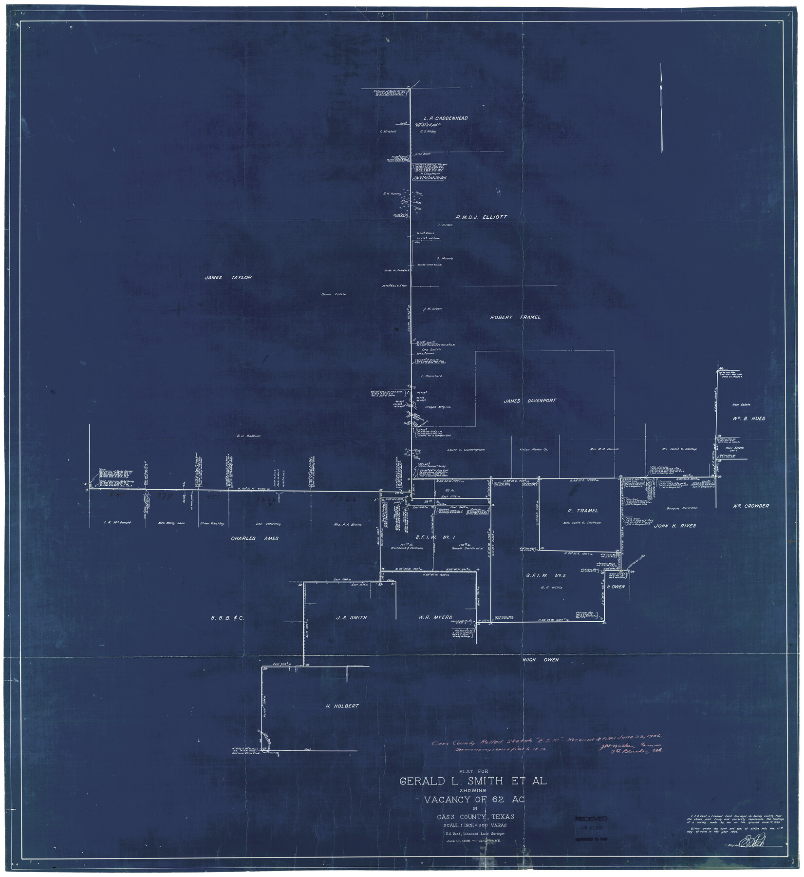
Cass County Rolled Sketch ESR2
Plat for Gerald L. Smith et al showing vacancy of 62 ac.
-
Map/Doc
8587
-
Collection
General Map Collection
-
Object Dates
6/17/1936 (Creation Date)
6/22/1936 (File Date)
-
People and Organizations
E.S. Rest (Surveyor/Engineer)
-
Counties
Cass
-
Subjects
Surveying Rolled Sketch
-
Height x Width
43.8 x 40.1 inches
111.3 x 101.9 cm
-
Medium
blueprint/diazo
-
Scale
1" = 300 varas
-
Comments
See Cass County Sketch File 24 (17436) for report.
Related maps
Cass County Sketch File 24

Print $16.00
- Digital $50.00
Cass County Sketch File 24
1936
Size 13.9 x 8.7 inches
Map/Doc 17436
Part of: General Map Collection
Milam County Boundary File 5a

Print $12.00
- Digital $50.00
Milam County Boundary File 5a
Size 14.1 x 8.5 inches
Map/Doc 57233
Edwards County Boundary File 29

Print $22.00
- Digital $50.00
Edwards County Boundary File 29
Size 15.4 x 31.0 inches
Map/Doc 65502
Crosby County Sketch File 20

Print $20.00
- Digital $50.00
Crosby County Sketch File 20
Size 25.9 x 18.3 inches
Map/Doc 11252
Ochiltree County Sketch File A

Print $22.00
- Digital $50.00
Ochiltree County Sketch File A
1888
Size 8.7 x 5.7 inches
Map/Doc 33167
Schleicher County Sketch File 26

Print $6.00
- Digital $50.00
Schleicher County Sketch File 26
1938
Size 9.3 x 14.5 inches
Map/Doc 36524
Duval County Sketch File 13

Print $4.00
- Digital $50.00
Duval County Sketch File 13
1876
Size 8.5 x 10.3 inches
Map/Doc 21306
Gaines County Rolled Sketch 26

Print $20.00
- Digital $50.00
Gaines County Rolled Sketch 26
1980
Size 28.0 x 15.5 inches
Map/Doc 5940
[Surveys in Austin's Colony by Horatio Chriesman along Mill and Cummins Creeks]
![68, [Surveys in Austin's Colony by Horatio Chriesman along Mill and Cummins Creeks], General Map Collection](https://historictexasmaps.com/wmedia_w700/maps/68.tif.jpg)
Print $20.00
- Digital $50.00
[Surveys in Austin's Colony by Horatio Chriesman along Mill and Cummins Creeks]
1830
Size 30.7 x 25.7 inches
Map/Doc 68
Duval County Boundary File 3h

Print $4.00
- Digital $50.00
Duval County Boundary File 3h
Size 10.0 x 8.0 inches
Map/Doc 52749
Concho County Sketch File 3

Print $6.00
- Digital $50.00
Concho County Sketch File 3
1857
Size 13.1 x 8.4 inches
Map/Doc 19124
Hays County Rolled Sketch 25

Print $20.00
- Digital $50.00
Hays County Rolled Sketch 25
1925
Size 17.5 x 40.0 inches
Map/Doc 6181
Duval County Rolled Sketch 30

Print $20.00
- Digital $50.00
Duval County Rolled Sketch 30
1947
Size 15.8 x 27.8 inches
Map/Doc 5747
You may also like
Val Verde County Sketch File 56

Print $2.00
- Digital $50.00
Val Verde County Sketch File 56
2006
Size 8.5 x 11.0 inches
Map/Doc 89016
Morris County Sketch File 3

Print $2.00
- Digital $50.00
Morris County Sketch File 3
Size 12.0 x 5.0 inches
Map/Doc 31967
Martin County Rolled Sketch 3

Print $20.00
- Digital $50.00
Martin County Rolled Sketch 3
Size 29.2 x 15.4 inches
Map/Doc 6664
Val Verde County Working Sketch 113

Print $40.00
- Digital $50.00
Val Verde County Working Sketch 113
2003
Size 54.9 x 34.6 inches
Map/Doc 78492
San Saba County Rolled Sketch 1

Print $3.00
- Digital $50.00
San Saba County Rolled Sketch 1
Size 11.7 x 9.0 inches
Map/Doc 7742
Map of surveys 189 & 190 T. C. R.R. Co. in Travis County, Texas

Print $20.00
- Digital $50.00
Map of surveys 189 & 190 T. C. R.R. Co. in Travis County, Texas
1915
Size 16.1 x 24.0 inches
Map/Doc 5079
Lamar County Sketch File 1

Print $4.00
- Digital $50.00
Lamar County Sketch File 1
1849
Size 8.0 x 8.2 inches
Map/Doc 29271
Presidio County Rolled Sketch 117

Print $20.00
- Digital $50.00
Presidio County Rolled Sketch 117
Size 29.1 x 28.8 inches
Map/Doc 7392
Railroad and County Map of Texas

Print $20.00
Railroad and County Map of Texas
1901
Size 33.1 x 37.1 inches
Map/Doc 76213
El Paso County Rolled Sketch RJ

Print $40.00
- Digital $50.00
El Paso County Rolled Sketch RJ
1919
Size 56.7 x 27.2 inches
Map/Doc 8865
General Highway Map, Fort Bend County, Texas

Print $20.00
General Highway Map, Fort Bend County, Texas
1939
Size 18.6 x 25.2 inches
Map/Doc 79093
Brazoria County Sketch File 45

Print $20.00
- Digital $50.00
Brazoria County Sketch File 45
1980
Size 32.0 x 43.1 inches
Map/Doc 10326