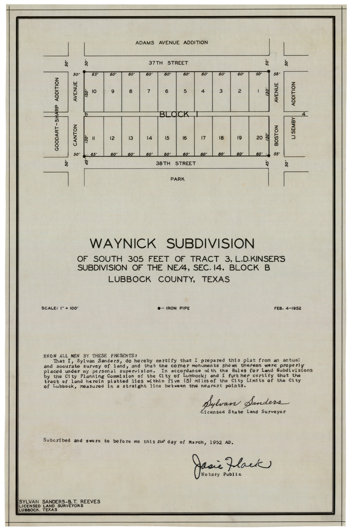
Waynick Subdivision
-
Map/Doc
92415
-
Collection
Twichell Survey Records
-
Object Dates
2/4/1952 (Creation Date)
-
People and Organizations
Sylvan Sanders (Surveyor/Engineer)
-
Counties
Lubbock
-
Height x Width
11.8 x 17.8 inches
30.0 x 45.2 cm
Part of: Twichell Survey Records
![92465, [Muleshoe], Twichell Survey Records](https://historictexasmaps.com/wmedia_w700/maps/92465-1.tif.jpg)
Castro County Texas

Print $20.00
- Digital $50.00
Castro County Texas
Size 34.0 x 37.5 inches
Map/Doc 92618
[Sketch focused on Southeast corner of Lubbock County]
![89899, [Sketch focused on Southeast corner of Lubbock County], Twichell Survey Records](https://historictexasmaps.com/wmedia_w700/maps/89899-1.tif.jpg)
Print $20.00
- Digital $50.00
[Sketch focused on Southeast corner of Lubbock County]
Size 42.8 x 36.9 inches
Map/Doc 89899
[Blocks 47, Z, XO2, M18, M23, M25, and H]
![91186, [Blocks 47, Z, XO2, M18, M23, M25, and H], Twichell Survey Records](https://historictexasmaps.com/wmedia_w700/maps/91186-1.tif.jpg)
Print $20.00
- Digital $50.00
[Blocks 47, Z, XO2, M18, M23, M25, and H]
Size 30.1 x 23.5 inches
Map/Doc 91186
Replat of Baker 2nd Addition to Lamesa, Part of Southwest Quarter, Section 71, Block 35, Dawson County, Texas

Print $20.00
- Digital $50.00
Replat of Baker 2nd Addition to Lamesa, Part of Southwest Quarter, Section 71, Block 35, Dawson County, Texas
1958
Size 9.9 x 18.8 inches
Map/Doc 92633
[Blocks XO2, Z, and a Portion of Block 47]
![91252, [Blocks XO2, Z, and a Portion of Block 47], Twichell Survey Records](https://historictexasmaps.com/wmedia_w700/maps/91252-1.tif.jpg)
Print $20.00
- Digital $50.00
[Blocks XO2, Z, and a Portion of Block 47]
1923
Size 19.5 x 9.0 inches
Map/Doc 91252
[Sabine County School Land and vicinity]
![90981, [Sabine County School Land and vicinity], Twichell Survey Records](https://historictexasmaps.com/wmedia_w700/maps/90981-1.tif.jpg)
Print $20.00
- Digital $50.00
[Sabine County School Land and vicinity]
Size 18.1 x 19.9 inches
Map/Doc 90981
Working Sketch in Stephens County

Print $2.00
- Digital $50.00
Working Sketch in Stephens County
1919
Size 9.2 x 11.4 inches
Map/Doc 91911
[B. S. & F. Block 9 and surrounding area]
![93070, [B. S. & F. Block 9 and surrounding area], Twichell Survey Records](https://historictexasmaps.com/wmedia_w700/maps/93070-1.tif.jpg)
Print $20.00
- Digital $50.00
[B. S. & F. Block 9 and surrounding area]
Size 18.3 x 26.1 inches
Map/Doc 93070
[Texas Boundary Line]
![92082, [Texas Boundary Line], Twichell Survey Records](https://historictexasmaps.com/wmedia_w700/maps/92082-1.tif.jpg)
Print $20.00
- Digital $50.00
[Texas Boundary Line]
Size 21.6 x 12.2 inches
Map/Doc 92082
[Coleman and McCullogh County Drilling Block]
![92968, [Coleman and McCullogh County Drilling Block], Twichell Survey Records](https://historictexasmaps.com/wmedia_w700/maps/92968-1.tif.jpg)
Print $20.00
- Digital $50.00
[Coleman and McCullogh County Drilling Block]
Size 16.6 x 18.6 inches
Map/Doc 92968

You may also like
Montague County Working Sketch 17

Print $20.00
- Digital $50.00
Montague County Working Sketch 17
1947
Size 22.1 x 30.0 inches
Map/Doc 71083
The Texas and Pacific Ry. Co., Station Map, Loraine, Texas

Print $20.00
- Digital $50.00
The Texas and Pacific Ry. Co., Station Map, Loraine, Texas
Size 11.6 x 18.6 inches
Map/Doc 64683
Irion County Sketch File 10

Print $20.00
- Digital $50.00
Irion County Sketch File 10
1936
Size 16.7 x 30.5 inches
Map/Doc 11825
Crockett County Rolled Sketch 41

Print $20.00
- Digital $50.00
Crockett County Rolled Sketch 41
Size 24.7 x 19.6 inches
Map/Doc 5591
Flight Mission No. DAG-28K, Frame 23, Matagorda County

Print $20.00
- Digital $50.00
Flight Mission No. DAG-28K, Frame 23, Matagorda County
1953
Size 18.6 x 22.5 inches
Map/Doc 86591
Dawson County Working Sketch 17

Print $20.00
- Digital $50.00
Dawson County Working Sketch 17
1961
Size 33.3 x 29.9 inches
Map/Doc 68561
La Salle County Rolled Sketch 12

Print $20.00
- Digital $50.00
La Salle County Rolled Sketch 12
Size 25.3 x 37.2 inches
Map/Doc 6575
[West Half of Potter County, South of River and West Half of Randall County]
![91828, [West Half of Potter County, South of River and West Half of Randall County], Twichell Survey Records](https://historictexasmaps.com/wmedia_w700/maps/91828.tif.jpg)
Print $20.00
- Digital $50.00
[West Half of Potter County, South of River and West Half of Randall County]
Size 25.9 x 43.0 inches
Map/Doc 91828
Travis County Sketch File 10

Print $16.00
- Digital $50.00
Travis County Sketch File 10
1863
Size 7.7 x 13.7 inches
Map/Doc 38292
Trinity River, Red Bank Sheet

Print $20.00
- Digital $50.00
Trinity River, Red Bank Sheet
1925
Size 16.4 x 24.4 inches
Map/Doc 69687
Foard County Rolled Sketch 15A

Print $20.00
- Digital $50.00
Foard County Rolled Sketch 15A
1889
Size 37.5 x 36.1 inches
Map/Doc 8339
San Patricio County Rolled Sketch 21

Print $20.00
- Digital $50.00
San Patricio County Rolled Sketch 21
1935
Size 25.9 x 24.7 inches
Map/Doc 7580