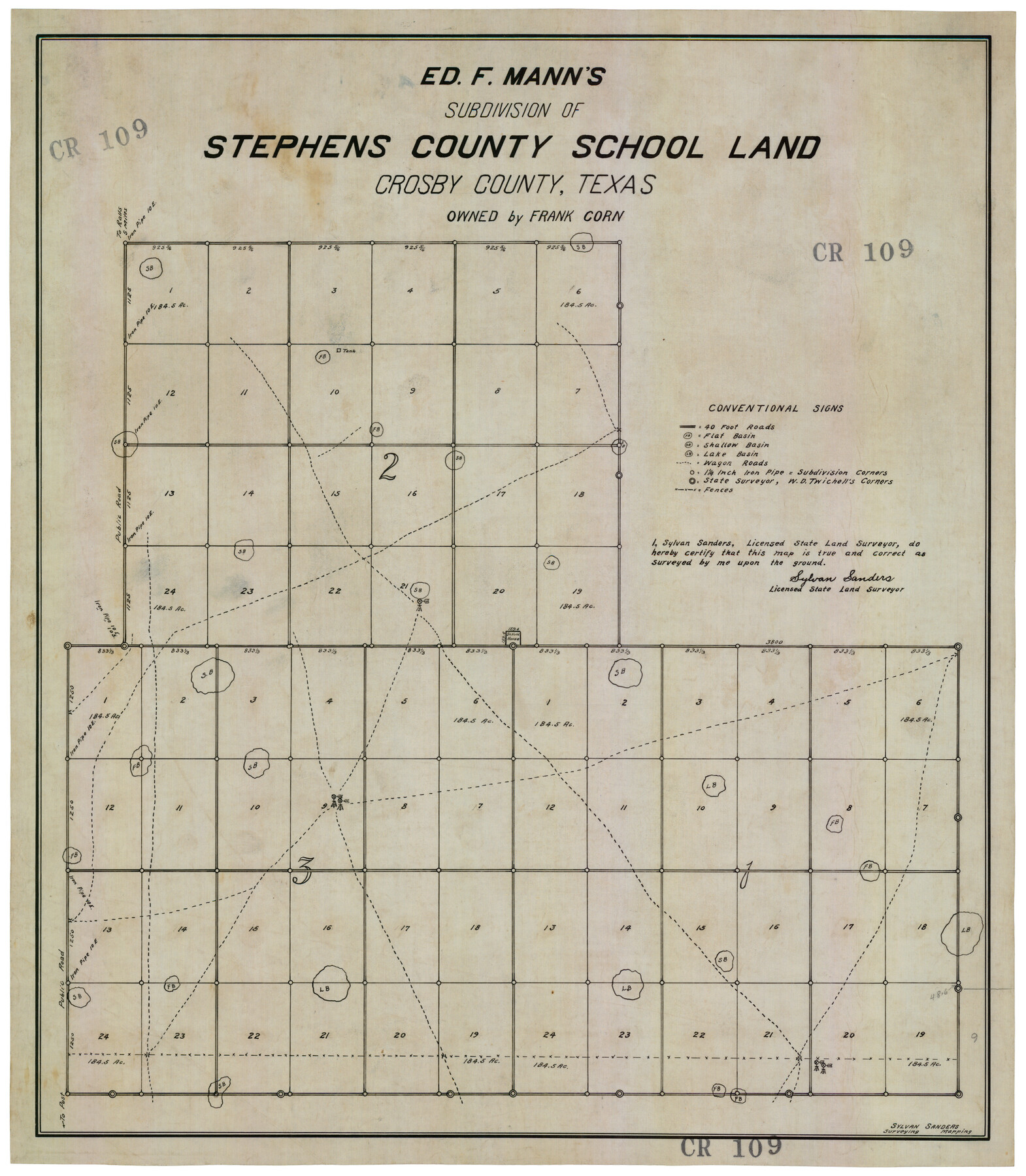
Ed F. Mann's Subdivision of Stephens County School Land, Crosby County, Texas
CR109
-
Map/Doc
92600
-
Collection
Twichell Survey Records
-
People and Organizations
Sylvan Sanders (Surveyor/Engineer)
-
Counties
Crosby
-
Height x Width
19.4 x 22.2 inches
49.3 x 56.4 cm
Part of: Twichell Survey Records
Working Sketch in Collingsworth County

Print $20.00
- Digital $50.00
Working Sketch in Collingsworth County
1910
Size 6.5 x 38.9 inches
Map/Doc 90728
Sylvan Sanders Map of Gaines County, Texas

Print $40.00
- Digital $50.00
Sylvan Sanders Map of Gaines County, Texas
Size 54.3 x 40.8 inches
Map/Doc 89844
[I. & G. N. Blocks 1 and 2]
![90333, [I. & G. N. Blocks 1 and 2], Twichell Survey Records](https://historictexasmaps.com/wmedia_w700/maps/90333-1.tif.jpg)
Print $20.00
- Digital $50.00
[I. & G. N. Blocks 1 and 2]
Size 21.2 x 37.5 inches
Map/Doc 90333
Replat of Baker 2nd Addition to Lamesa, Part of Southwest Quarter, Section 71, Block 35, Dawson County, Texas

Print $20.00
- Digital $50.00
Replat of Baker 2nd Addition to Lamesa, Part of Southwest Quarter, Section 71, Block 35, Dawson County, Texas
1958
Size 9.9 x 18.8 inches
Map/Doc 92633
T. & N. O. RR. Company, Block 1

Print $20.00
- Digital $50.00
T. & N. O. RR. Company, Block 1
Size 35.3 x 19.5 inches
Map/Doc 90740
[Surveys Surrounding I. G. Yates S.F. 12394]
![91560, [Surveys Surrounding I. G. Yates S.F. 12394], Twichell Survey Records](https://historictexasmaps.com/wmedia_w700/maps/91560-1.tif.jpg)
Print $20.00
- Digital $50.00
[Surveys Surrounding I. G. Yates S.F. 12394]
Size 18.6 x 7.4 inches
Map/Doc 91560
R. C. Johnson Farm NW Quarter, Section 3

Print $20.00
- Digital $50.00
R. C. Johnson Farm NW Quarter, Section 3
Size 12.3 x 14.9 inches
Map/Doc 92405
This Map Shows the Surveys 61 to 69 by Dod's Monuments in Accordance with Dod's Course in Stanolind vs. State

Print $20.00
- Digital $50.00
This Map Shows the Surveys 61 to 69 by Dod's Monuments in Accordance with Dod's Course in Stanolind vs. State
Size 17.6 x 12.5 inches
Map/Doc 91688
T and P as Surveyed January 1876, Blocks 35-36

Print $40.00
- Digital $50.00
T and P as Surveyed January 1876, Blocks 35-36
1876
Size 29.0 x 95.2 inches
Map/Doc 93184
![91800, [Block M-19], Twichell Survey Records](https://historictexasmaps.com/wmedia_w700/maps/91800-1.tif.jpg)
[Portions of Blocks T1, B, and T]
![90950, [Portions of Blocks T1, B, and T], Twichell Survey Records](https://historictexasmaps.com/wmedia_w700/maps/90950-1.tif.jpg)
Print $2.00
- Digital $50.00
[Portions of Blocks T1, B, and T]
1910
Size 13.8 x 4.3 inches
Map/Doc 90950
[Blk. M, T. & P. Blocks 33-36, Townships 5N and 6N]
![90548, [Blk. M, T. & P. Blocks 33-36, Townships 5N and 6N], Twichell Survey Records](https://historictexasmaps.com/wmedia_w700/maps/90548-1.tif.jpg)
Print $20.00
- Digital $50.00
[Blk. M, T. & P. Blocks 33-36, Townships 5N and 6N]
Size 12.3 x 16.1 inches
Map/Doc 90548
You may also like
[Surveys in Austin's Colony near La Bahia Road]
![200, [Surveys in Austin's Colony near La Bahia Road], General Map Collection](https://historictexasmaps.com/wmedia_w700/maps/200.tif.jpg)
Print $20.00
- Digital $50.00
[Surveys in Austin's Colony near La Bahia Road]
1821
Size 10.4 x 20.2 inches
Map/Doc 200
Beaumont, Texas

Print $20.00
- Digital $50.00
Beaumont, Texas
1930
Size 10.3 x 32.7 inches
Map/Doc 96428
Webb County Working Sketch 67

Print $40.00
- Digital $50.00
Webb County Working Sketch 67
1966
Size 60.9 x 43.7 inches
Map/Doc 72434
[Surveying Sketch of J.H. Vermillion, S.L. Fite, et al in Zapata County]
![698, [Surveying Sketch of J.H. Vermillion, S.L. Fite, et al in Zapata County], Maddox Collection](https://historictexasmaps.com/wmedia_w700/maps/0698.tif.jpg)
Print $20.00
- Digital $50.00
[Surveying Sketch of J.H. Vermillion, S.L. Fite, et al in Zapata County]
1914
Size 15.6 x 12.1 inches
Map/Doc 698
Map of Briscoe County

Print $20.00
- Digital $50.00
Map of Briscoe County
1901
Size 42.0 x 35.0 inches
Map/Doc 4758
Map of the Texas and Pacific Railway and connections

Print $20.00
- Digital $50.00
Map of the Texas and Pacific Railway and connections
1927
Size 8.2 x 9.4 inches
Map/Doc 95773
Old Miscellaneous File 12

Print $14.00
- Digital $50.00
Old Miscellaneous File 12
1899
Size 14.2 x 8.6 inches
Map/Doc 75439

Kent County Working Sketch 21

Print $20.00
- Digital $50.00
Kent County Working Sketch 21
1981
Size 43.5 x 37.5 inches
Map/Doc 70028
Schleicher County Working Sketch 2

Print $20.00
- Digital $50.00
Schleicher County Working Sketch 2
1903
Size 14.7 x 19.4 inches
Map/Doc 63804
Flight Mission No. BQR-20K, Frame 7, Brazoria County

Print $20.00
- Digital $50.00
Flight Mission No. BQR-20K, Frame 7, Brazoria County
1952
Size 18.6 x 22.4 inches
Map/Doc 84109
Kinney County Working Sketch 35

Print $40.00
- Digital $50.00
Kinney County Working Sketch 35
1965
Size 58.3 x 48.6 inches
Map/Doc 70217