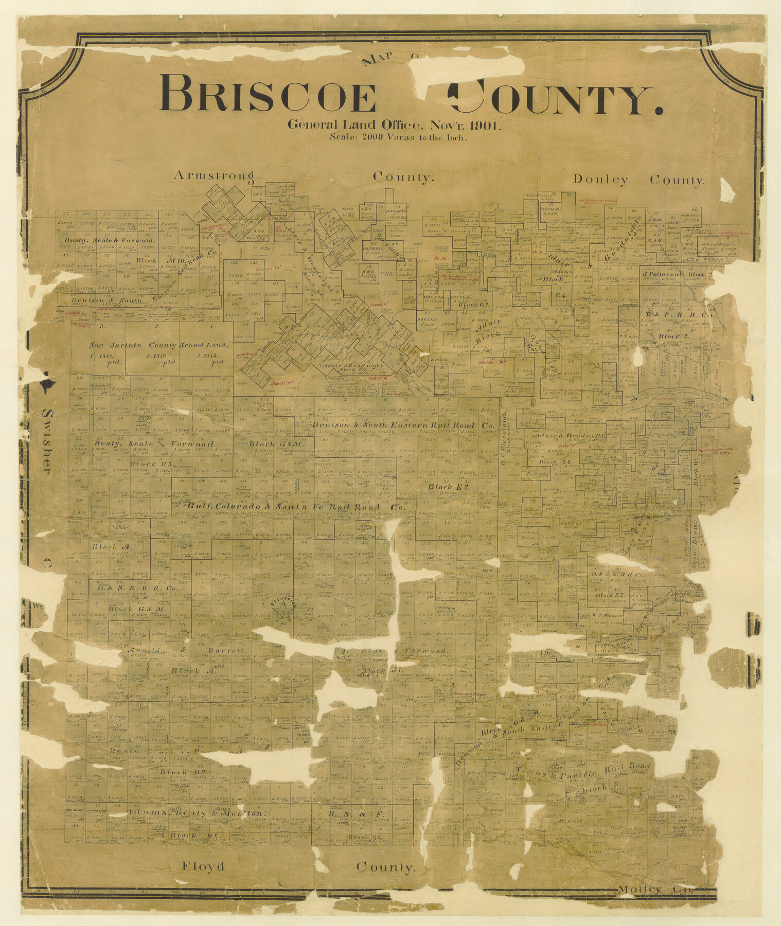
Map of Briscoe County
-
Map/Doc
4758
-
Collection
General Map Collection
-
Object Dates
1901 (Creation Date)
-
People and Organizations
Texas General Land Office (Publisher)
-
Counties
Briscoe
-
Subjects
County
-
Height x Width
42.0 x 35.0 inches
106.7 x 88.9 cm
-
Comments
Conservation funded in 2006 by Friends of The Texas General Land Office.
-
Features
Pilgrim Creek
Campbell Creek
Bull Run Creek
Prairie Dog Town Fork of Red River
Mulberry Creek
Timber Lake
Hackberry Creek
Troublesome Creek
Tule Canon
Battle Creek
Mexican Creek
Antelope Creek
Silverton
Little Red River
Pease River
Part of: General Map Collection
Nueces County Sketch File 22a

Print $6.00
- Digital $50.00
Nueces County Sketch File 22a
1884
Size 9.3 x 11.8 inches
Map/Doc 32561
Concho County Working Sketch 20

Print $20.00
- Digital $50.00
Concho County Working Sketch 20
1957
Size 40.0 x 38.1 inches
Map/Doc 68202
Rusk County Rolled Sketch 9A

Print $20.00
- Digital $50.00
Rusk County Rolled Sketch 9A
1971
Size 30.4 x 19.1 inches
Map/Doc 7547
National Railways of Mexico

Digital $50.00
National Railways of Mexico
1966
Size 8.9 x 17.6 inches
Map/Doc 94189
[Sketch for Mineral Application 18874 - Pecos River Bed, W. J. Bonner]
![65583, [Sketch for Mineral Application 18874 - Pecos River Bed, W. J. Bonner], General Map Collection](https://historictexasmaps.com/wmedia_w700/maps/65583.tif.jpg)
Print $20.00
- Digital $50.00
[Sketch for Mineral Application 18874 - Pecos River Bed, W. J. Bonner]
1927
Size 37.6 x 32.3 inches
Map/Doc 65583
Coleman County Rolled Sketch 2

Print $20.00
- Digital $50.00
Coleman County Rolled Sketch 2
Size 18.3 x 24.9 inches
Map/Doc 5528
Leon County Working Sketch 59

Print $20.00
- Digital $50.00
Leon County Working Sketch 59
1998
Size 19.2 x 25.5 inches
Map/Doc 70459
Map of Europe engraved to illustrate Mitchell's school and family geography

Print $20.00
- Digital $50.00
Map of Europe engraved to illustrate Mitchell's school and family geography
1839
Size 9.5 x 11.8 inches
Map/Doc 93502
Wichita County Working Sketch Graphic Index

Print $20.00
- Digital $50.00
Wichita County Working Sketch Graphic Index
1971
Size 36.7 x 38.5 inches
Map/Doc 76739
[Section of] Carte du Mexique et de la Nouvelle Espagne
![97485, [Section of] Carte du Mexique et de la Nouvelle Espagne, General Map Collection](https://historictexasmaps.com/wmedia_w700/maps/97485.tif.jpg)
[Section of] Carte du Mexique et de la Nouvelle Espagne
1779
Size 14.0 x 16.7 inches
Map/Doc 97485
Flight Mission No. BQY-4M, Frame 58, Harris County

Print $20.00
- Digital $50.00
Flight Mission No. BQY-4M, Frame 58, Harris County
1953
Size 18.5 x 22.3 inches
Map/Doc 85267
Burnet County Sketch File 28

Print $8.00
- Digital $50.00
Burnet County Sketch File 28
1874
Size 12.8 x 8.5 inches
Map/Doc 16740
You may also like

Burleson County Sketch File 9

Print $12.00
- Digital $50.00
Burleson County Sketch File 9
1929
Size 14.2 x 8.1 inches
Map/Doc 16657
Map of Blanco County, Texas

Print $20.00
- Digital $50.00
Map of Blanco County, Texas
1880
Size 28.5 x 20.1 inches
Map/Doc 406
[Cotton Belt, St. Louis Southwestern Railway of Texas, Alignment through Smith County]
![64376, [Cotton Belt, St. Louis Southwestern Railway of Texas, Alignment through Smith County], General Map Collection](https://historictexasmaps.com/wmedia_w700/maps/64376-1.tif.jpg)
Print $20.00
- Digital $50.00
[Cotton Belt, St. Louis Southwestern Railway of Texas, Alignment through Smith County]
1903
Size 22.0 x 29.3 inches
Map/Doc 64376
Hamilton County Working Sketch 2

Print $20.00
- Digital $50.00
Hamilton County Working Sketch 2
1923
Size 12.9 x 15.7 inches
Map/Doc 63340
Map of the State of Coahuila and Texas

Print $20.00
- Digital $50.00
Map of the State of Coahuila and Texas
1834
Size 13.2 x 14.7 inches
Map/Doc 93848
Live Oak County Sketch File 28

Print $10.00
- Digital $50.00
Live Oak County Sketch File 28
1922
Size 14.3 x 8.5 inches
Map/Doc 30314
Comanche County Sketch File 16a

Print $4.00
- Digital $50.00
Comanche County Sketch File 16a
Size 6.1 x 8.5 inches
Map/Doc 19084
Fort Bend County Sketch File 3a

Print $6.00
- Digital $50.00
Fort Bend County Sketch File 3a
1874
Size 8.3 x 8.0 inches
Map/Doc 22882
Ellis County Sketch File 9

Print $40.00
- Digital $50.00
Ellis County Sketch File 9
1860
Size 16.0 x 13.0 inches
Map/Doc 21843
Howard County Boundary File 4a

Print $60.00
- Digital $50.00
Howard County Boundary File 4a
Size 70.6 x 10.0 inches
Map/Doc 55166
Orange County Working Sketch 47

Print $20.00
- Digital $50.00
Orange County Working Sketch 47
1987
Size 27.5 x 26.5 inches
Map/Doc 71379