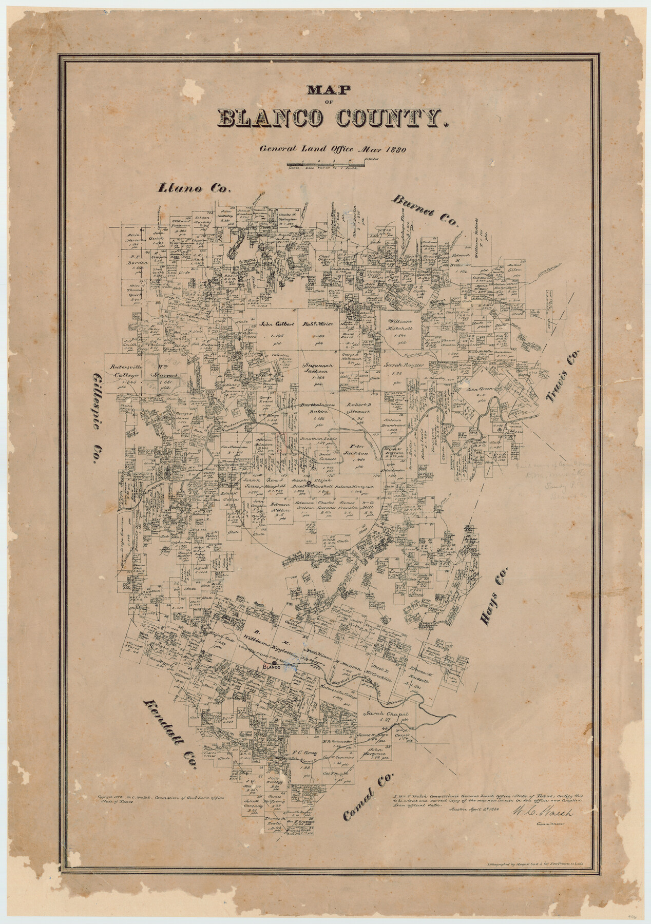
Map of Blanco County, Texas
-
Map/Doc
406
-
Collection
Maddox Collection
-
Object Dates
3/1880 (Creation Date)
-
People and Organizations
General Land Office (Publisher)
W.C. Walsh (GLO Commissioner)
August Gast & Co. (Lithographer)
-
Counties
Blanco
-
Subjects
County
-
Height x Width
28.5 x 20.1 inches
72.4 x 51.1 cm
-
Scale
1" = 4000 varas
-
Comments
Conservation funded in 2004 with donation from Charles and Sue Currie
-
Features
Spring Creek
Rio Blanco
Webb Creek
Roger's Br[anch of the Rio Blanco]
Blanco
Martin's Fork of the Rio Blanco
Onion Creek
Yager Creek
William's Creek
Rock Creek
Flat Creek
Grape Creek
Comanche Creek
Rio Pedernales
Cypress Creek
Shovel Mount[ain]
Fall Creek
Little Cypress Creek
Double Horn Creek
Flat Rock Creek
Slick Rock Creek
Pecan Creek
Walnut Creek
Part of: Maddox Collection
Howard County, Texas

Print $20.00
- Digital $50.00
Howard County, Texas
1870
Size 22.7 x 17.9 inches
Map/Doc 733
[Unknown Building Sketch]
![75793, [Unknown Building Sketch], Maddox Collection](https://historictexasmaps.com/wmedia_w700/maps/75793.tif.jpg)
Print $20.00
- Digital $50.00
[Unknown Building Sketch]
Size 15.3 x 23.0 inches
Map/Doc 75793
Sketch of Dickens Co.

Print $20.00
- Digital $50.00
Sketch of Dickens Co.
1884
Size 17.6 x 14.5 inches
Map/Doc 75766
Hemphill County, Texas

Print $20.00
- Digital $50.00
Hemphill County, Texas
1880
Size 19.7 x 18.6 inches
Map/Doc 549
[Sketch in Reagan, Irion and Tom Green Counties]
![75551, [Sketch in Reagan, Irion and Tom Green Counties], Maddox Collection](https://historictexasmaps.com/wmedia_w700/maps/75551.tif.jpg)
Print $20.00
- Digital $50.00
[Sketch in Reagan, Irion and Tom Green Counties]
Size 12.5 x 30.1 inches
Map/Doc 75551
[Surveying Sketch of Jesse McGee in Sabine and Newton Counties]
![78480, [Surveying Sketch of Jesse McGee in Sabine and Newton Counties], Maddox Collection](https://historictexasmaps.com/wmedia_w700/maps/78480.tif.jpg)
Print $20.00
- Digital $50.00
[Surveying Sketch of Jesse McGee in Sabine and Newton Counties]
Size 17.1 x 19.7 inches
Map/Doc 78480
Refugio County, Texas

Print $20.00
- Digital $50.00
Refugio County, Texas
1879
Size 19.9 x 29.0 inches
Map/Doc 600
Sketch of Surveys in Knox, Baylor, Haskell and Throckmorton Ctes

Print $40.00
- Digital $50.00
Sketch of Surveys in Knox, Baylor, Haskell and Throckmorton Ctes
1888
Size 43.3 x 58.5 inches
Map/Doc 4386
Map of Fisher & Miller's Colony made from the records in the office of the District Surveyor of Bexar comprising also all the recent surveys

Print $20.00
- Digital $50.00
Map of Fisher & Miller's Colony made from the records in the office of the District Surveyor of Bexar comprising also all the recent surveys
1855
Size 22.6 x 36.2 inches
Map/Doc 633
[Sketch of surveys north of "Las Animas" grant, Webb County]
![668, [Sketch of surveys north of "Las Animas" grant, Webb County], Maddox Collection](https://historictexasmaps.com/wmedia_w700/maps/668.tif.jpg)
Print $3.00
- Digital $50.00
[Sketch of surveys north of "Las Animas" grant, Webb County]
1908
Size 16.9 x 10.7 inches
Map/Doc 668
Map of Block 1, H. & G. N. R. R. Co., Dickens and Kent Counties Texas
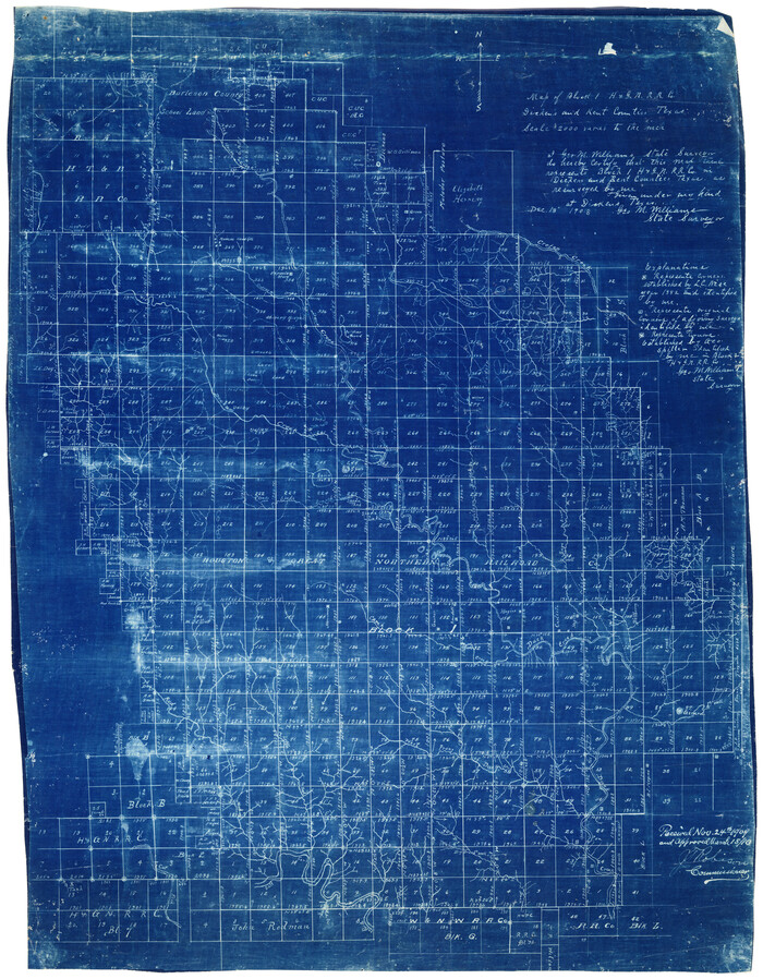
Print $20.00
- Digital $50.00
Map of Block 1, H. & G. N. R. R. Co., Dickens and Kent Counties Texas
1908
Size 32.0 x 24.2 inches
Map/Doc 10780
Plat Town of Swearingen, Cottle Co., Texas

Print $20.00
- Digital $50.00
Plat Town of Swearingen, Cottle Co., Texas
1918
Size 39.8 x 30.6 inches
Map/Doc 513
You may also like
Wilbarger County Working Sketch 22

Print $20.00
- Digital $50.00
Wilbarger County Working Sketch 22
1983
Size 39.8 x 33.6 inches
Map/Doc 72560
Kuechler's Corners, Texas & Pacific Ry. Co. 80 Mile Reserve

Print $703.00
- Digital $50.00
Kuechler's Corners, Texas & Pacific Ry. Co. 80 Mile Reserve
1934
Size 11.0 x 8.5 inches
Map/Doc 2248
Map of north end of Brazos Island

Print $20.00
- Digital $50.00
Map of north end of Brazos Island
1845
Size 24.2 x 18.3 inches
Map/Doc 72920
Liberty County Working Sketch 1

Print $20.00
- Digital $50.00
Liberty County Working Sketch 1
Size 26.5 x 29.7 inches
Map/Doc 70460
Sutton County

Print $40.00
- Digital $50.00
Sutton County
1941
Size 43.8 x 56.5 inches
Map/Doc 95647
![4781, Coke Co[unty], General Map Collection](https://historictexasmaps.com/wmedia_w700/maps/4781.tif.jpg)
[Hockley, Lubbock, Terry and Lynn Corner]
![92954, [Hockley, Lubbock, Terry and Lynn Corner], Twichell Survey Records](https://historictexasmaps.com/wmedia_w700/maps/92954-1.tif.jpg)
Print $20.00
- Digital $50.00
[Hockley, Lubbock, Terry and Lynn Corner]
Size 24.5 x 18.9 inches
Map/Doc 92954
The Town of Charlotte Situated on the San Antonio, Uvalde and Gulf Railway in Atascosa County, Texas

Print $20.00
- Digital $50.00
The Town of Charlotte Situated on the San Antonio, Uvalde and Gulf Railway in Atascosa County, Texas
1911
Size 29.7 x 24.5 inches
Map/Doc 4823
Webb County Sketch File 44b-1

Print $20.00
- Digital $50.00
Webb County Sketch File 44b-1
1936
Size 29.0 x 18.0 inches
Map/Doc 12641
City of Austin, Texas and Suburban Territory

Print $40.00
- Digital $50.00
City of Austin, Texas and Suburban Territory
1952
Size 52.9 x 47.2 inches
Map/Doc 73582
Val Verde County Sketch File 14

Print $20.00
- Digital $50.00
Val Verde County Sketch File 14
1879
Size 19.8 x 14.7 inches
Map/Doc 12565
Packery Channel

Print $20.00
- Digital $50.00
Packery Channel
1950
Size 17.6 x 17.5 inches
Map/Doc 2997