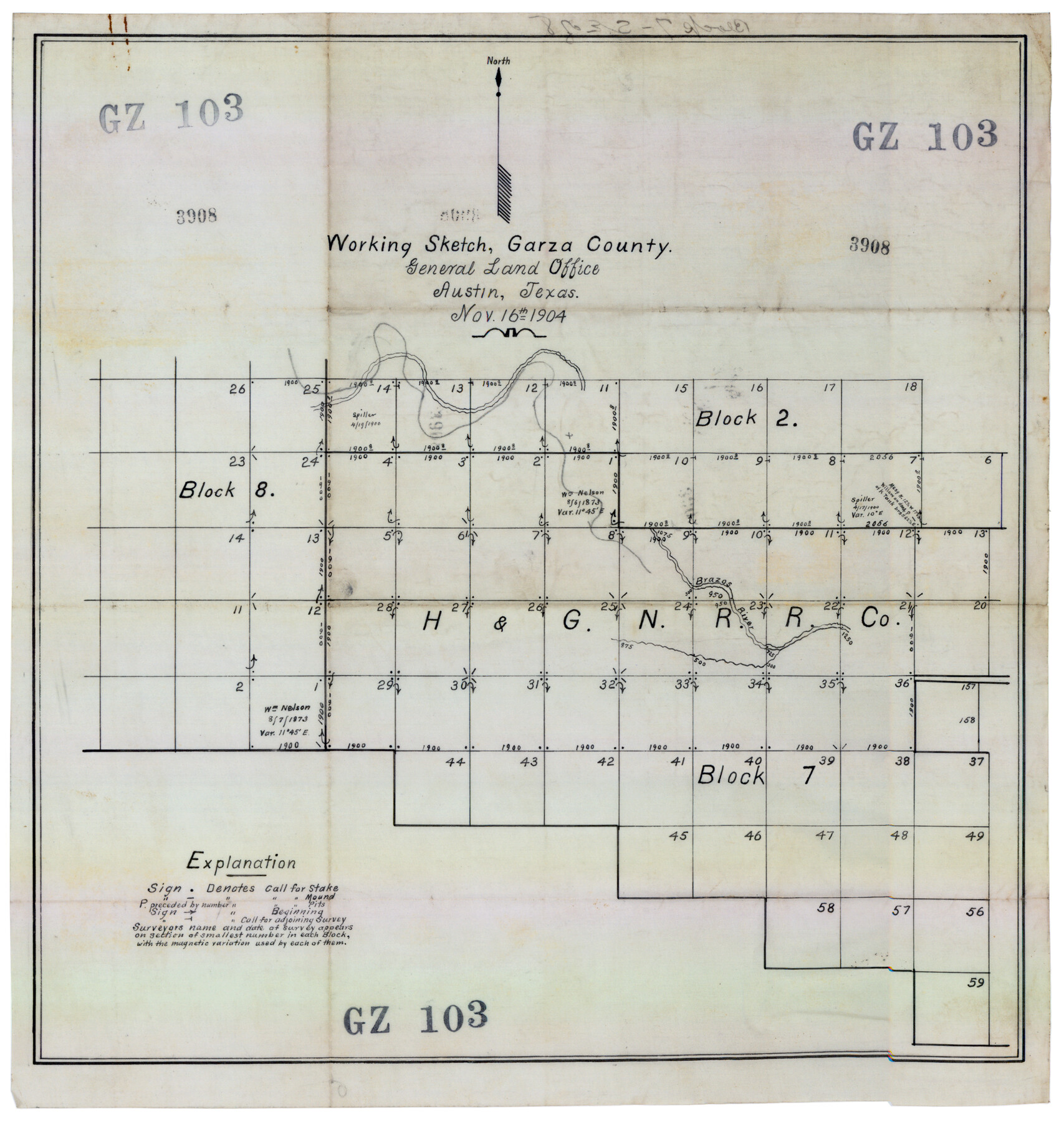
Working Sketch, Garza County
GZ103
-
Map/Doc
92693
-
Collection
Twichell Survey Records
-
Object Dates
11/16/1904 (Creation Date)
-
Counties
Garza
-
Height x Width
13.9 x 14.7 inches
35.3 x 37.3 cm
Part of: Twichell Survey Records
Map No. 1 - Surveys Located in 1881 as they appear on the ground

Print $20.00
- Digital $50.00
Map No. 1 - Surveys Located in 1881 as they appear on the ground
Size 29.6 x 18.8 inches
Map/Doc 91889
Map Showing Block HG and Connecting Surveys

Print $2.00
- Digital $50.00
Map Showing Block HG and Connecting Surveys
1907
Size 9.2 x 13.7 inches
Map/Doc 90681
Tahoka Consolidated Independent School District

Print $20.00
- Digital $50.00
Tahoka Consolidated Independent School District
Size 34.1 x 22.1 inches
Map/Doc 92943
[Sketch showing Panhandle and Santa Fe Railroad, Compress Spur and Seed House structures]
![92880, [Sketch showing Panhandle and Santa Fe Railroad, Compress Spur and Seed House structures], Twichell Survey Records](https://historictexasmaps.com/wmedia_w700/maps/92880-1.tif.jpg)
Print $20.00
- Digital $50.00
[Sketch showing Panhandle and Santa Fe Railroad, Compress Spur and Seed House structures]
Size 20.8 x 22.8 inches
Map/Doc 92880
[Section 1, Block 12, H. & G. N. RR. Co.]
![91651, [Section 1, Block 12, H. & G. N. RR. Co.], Twichell Survey Records](https://historictexasmaps.com/wmedia_w700/maps/91651-1.tif.jpg)
Print $3.00
- Digital $50.00
[Section 1, Block 12, H. & G. N. RR. Co.]
Size 12.9 x 9.6 inches
Map/Doc 91651
[Sketch showing H. & T. C. Block 47]
![91699, [Sketch showing H. & T. C. Block 47], Twichell Survey Records](https://historictexasmaps.com/wmedia_w700/maps/91699-1.tif.jpg)
Print $2.00
- Digital $50.00
[Sketch showing H. & T. C. Block 47]
Size 6.1 x 6.7 inches
Map/Doc 91699
City of Andrews

Print $20.00
- Digital $50.00
City of Andrews
1951
Size 25.1 x 24.2 inches
Map/Doc 92454
[Portion of Terry & Lynn County Lines]
![92906, [Portion of Terry & Lynn County Lines], Twichell Survey Records](https://historictexasmaps.com/wmedia_w700/maps/92906-1.tif.jpg)
Print $20.00
- Digital $50.00
[Portion of Terry & Lynn County Lines]
Size 22.6 x 14.0 inches
Map/Doc 92906

[Worksheets related to the Wilson Strickland survey and vicinity]
![91381, [Worksheets related to the Wilson Strickland survey and vicinity], Twichell Survey Records](https://historictexasmaps.com/wmedia_w700/maps/91381-1.tif.jpg)
Print $20.00
- Digital $50.00
[Worksheets related to the Wilson Strickland survey and vicinity]
Size 20.1 x 24.8 inches
Map/Doc 91381
Working Drawing Compiled from Field Notes of the Sand Hills Area - Crane Co. Tex.

Print $20.00
- Digital $50.00
Working Drawing Compiled from Field Notes of the Sand Hills Area - Crane Co. Tex.
Size 43.5 x 30.8 inches
Map/Doc 90461
[Pablo Montoya Grant]
![93160, [Pablo Montoya Grant], Twichell Survey Records](https://historictexasmaps.com/wmedia_w700/maps/93160-1.tif.jpg)
Print $40.00
- Digital $50.00
[Pablo Montoya Grant]
Size 50.1 x 52.3 inches
Map/Doc 93160
You may also like
Map of Texas and the Countries Adjacent

Map of Texas and the Countries Adjacent
1844
Size 19.0 x 29.6 inches
Map/Doc 94561
Andrews County Sketch File 5

Print $4.00
- Digital $50.00
Andrews County Sketch File 5
1936
Size 11.8 x 8.8 inches
Map/Doc 12823
Flight Mission No. DQO-11K, Frame 27, Galveston County

Print $20.00
- Digital $50.00
Flight Mission No. DQO-11K, Frame 27, Galveston County
1952
Size 18.8 x 22.4 inches
Map/Doc 85224
Blocks T1, T2, T3, S3, A, O5, and Capitol Leagues]
![91074, Blocks T1, T2, T3, S3, A, O5, and Capitol Leagues], Twichell Survey Records](https://historictexasmaps.com/wmedia_w700/maps/91074-1.tif.jpg)
Print $20.00
- Digital $50.00
Blocks T1, T2, T3, S3, A, O5, and Capitol Leagues]
Size 30.0 x 33.4 inches
Map/Doc 91074
Controlled Mosaic by Jack Amman Photogrammetric Engineers, Inc - Sheet 57

Print $20.00
- Digital $50.00
Controlled Mosaic by Jack Amman Photogrammetric Engineers, Inc - Sheet 57
1954
Size 20.0 x 24.0 inches
Map/Doc 83516
[T. T. RR. Co. Block 8 and vicinity]
![90795, [T. T. RR. Co. Block 8 and vicinity], Twichell Survey Records](https://historictexasmaps.com/wmedia_w700/maps/90795-1.tif.jpg)
Print $20.00
- Digital $50.00
[T. T. RR. Co. Block 8 and vicinity]
Size 20.3 x 15.2 inches
Map/Doc 90795
Marion County Working Sketch 5

Print $20.00
- Digital $50.00
Marion County Working Sketch 5
1910
Size 24.5 x 15.2 inches
Map/Doc 70780
Flight Mission No. BRA-6M, Frame 73, Jefferson County

Print $20.00
- Digital $50.00
Flight Mission No. BRA-6M, Frame 73, Jefferson County
1953
Size 18.6 x 22.3 inches
Map/Doc 85417
Val Verde County Rolled Sketch 51

Print $40.00
- Digital $50.00
Val Verde County Rolled Sketch 51
1937
Size 29.4 x 48.4 inches
Map/Doc 10075
Map of the Passo Cavallo

Print $20.00
- Digital $50.00
Map of the Passo Cavallo
1853
Size 18.0 x 27.0 inches
Map/Doc 73011
Terrell County Sketch File 19

Print $6.00
- Digital $50.00
Terrell County Sketch File 19
1910
Size 10.2 x 12.1 inches
Map/Doc 37944
Sutton County Working Sketch 45
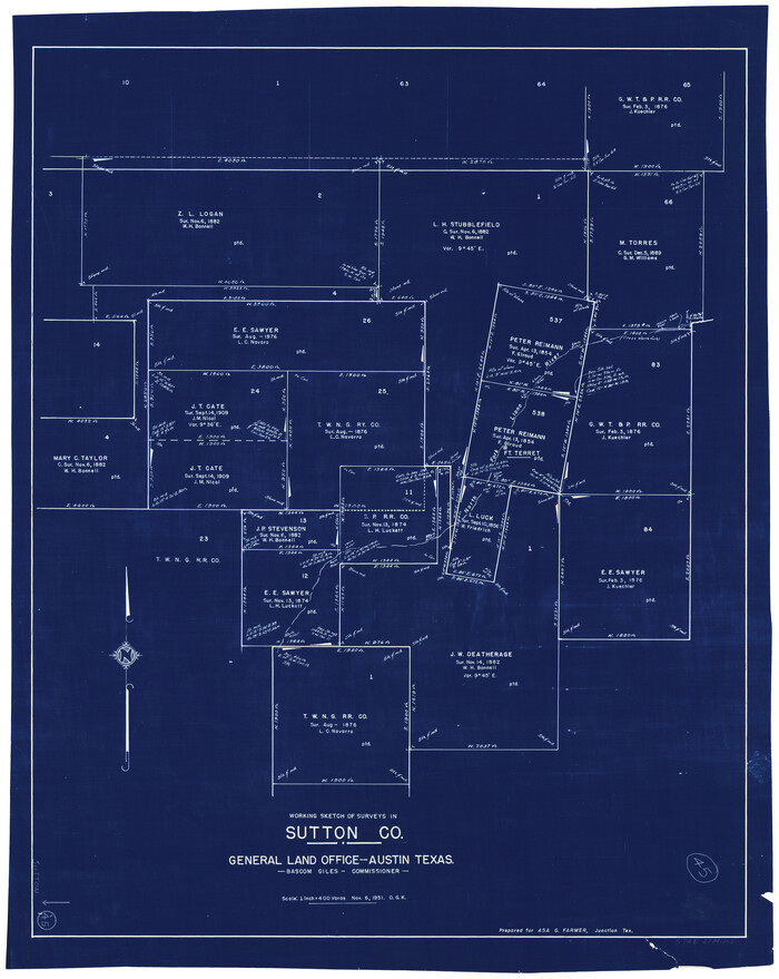
Print $20.00
- Digital $50.00
Sutton County Working Sketch 45
1951
Size 33.4 x 26.5 inches
Map/Doc 62388