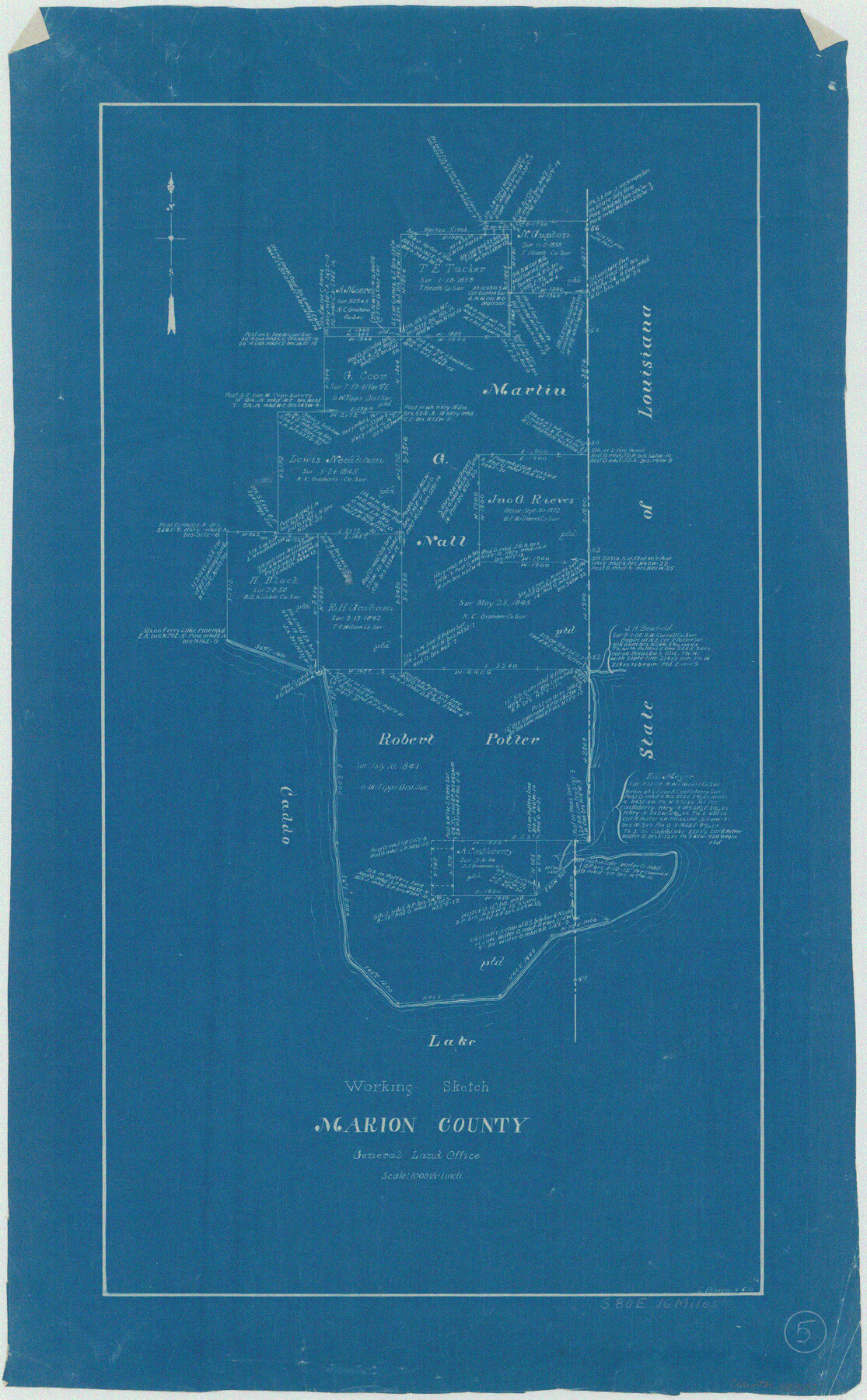
Marion County Working Sketch 5
-
Map/Doc
70780
-
Collection
General Map Collection
-
Object Dates
4/6/1910 (Creation Date)
-
People and Organizations
L. Ehlinger (Draftsman)
-
Counties
Marion
-
Subjects
Surveying Working Sketch
-
Height x Width
24.5 x 15.2 inches
62.2 x 38.6 cm
-
Scale
1" = 1000 varas
Part of: General Map Collection
Flight Mission No. DCL-4C, Frame 148, Kenedy County

Print $20.00
- Digital $50.00
Flight Mission No. DCL-4C, Frame 148, Kenedy County
1943
Size 18.6 x 22.5 inches
Map/Doc 85826
Baylor County Sketch File 3

Print $4.00
- Digital $50.00
Baylor County Sketch File 3
1856
Size 12.4 x 8.5 inches
Map/Doc 14124
Map of Jefferson County

Print $20.00
- Digital $50.00
Map of Jefferson County
1840
Size 34.8 x 27.0 inches
Map/Doc 3726
PSL Field Notes for Block CS in Dallam County

PSL Field Notes for Block CS in Dallam County
Map/Doc 81649

Clay County Boundary File 19

Print $8.00
- Digital $50.00
Clay County Boundary File 19
1924
Size 3.3 x 5.5 inches
Map/Doc 65511
Hutchinson County Working Sketch 17

Print $40.00
- Digital $50.00
Hutchinson County Working Sketch 17
1955
Size 47.2 x 128.6 inches
Map/Doc 66375
Jefferson County Aerial Photograph Index Sheet 7

Print $20.00
- Digital $50.00
Jefferson County Aerial Photograph Index Sheet 7
1953
Size 23.3 x 16.9 inches
Map/Doc 83711
Andrews County Rolled Sketch 40

Print $20.00
- Digital $50.00
Andrews County Rolled Sketch 40
Size 37.2 x 23.0 inches
Map/Doc 77180
Dickens County Working Sketch 5b

Print $40.00
- Digital $50.00
Dickens County Working Sketch 5b
1917
Size 59.4 x 43.3 inches
Map/Doc 68653
Blanco County Rolled Sketch 15

Print $20.00
- Digital $50.00
Blanco County Rolled Sketch 15
Size 12.9 x 13.7 inches
Map/Doc 5151
Pecos County Working Sketch 100

Print $20.00
- Digital $50.00
Pecos County Working Sketch 100
1970
Size 42.9 x 31.6 inches
Map/Doc 71573
You may also like
Sketch of Survey 3, Block 1 in Dickens and King Counties
Print $20.00
- Digital $50.00
Sketch of Survey 3, Block 1 in Dickens and King Counties
1914
Size 10.8 x 28.2 inches
Map/Doc 10766
Motley County Working Sketch 5

Print $20.00
- Digital $50.00
Motley County Working Sketch 5
1940
Size 22.5 x 20.3 inches
Map/Doc 71210
A true copy of Peck's field book page 1, except classification of lands

Print $2.00
- Digital $50.00
A true copy of Peck's field book page 1, except classification of lands
1876
Size 5.3 x 12.0 inches
Map/Doc 91979
Brewster County Boundary File 1b

Print $32.00
- Digital $50.00
Brewster County Boundary File 1b
Size 9.2 x 11.3 inches
Map/Doc 50740
Flight Mission No. BQR-9K, Frame 47, Brazoria County

Print $20.00
- Digital $50.00
Flight Mission No. BQR-9K, Frame 47, Brazoria County
1952
Size 18.7 x 22.4 inches
Map/Doc 84051
Map of the Reconnaissance in Texas by Lieuts Blake & Meade of the Corps of Topl. Engrs.

Print $20.00
- Digital $50.00
Map of the Reconnaissance in Texas by Lieuts Blake & Meade of the Corps of Topl. Engrs.
1845
Size 27.7 x 18.5 inches
Map/Doc 72892
Mapa de los Estados Unidos Mejicanos arreglado a la distribucion que en diversos decretos ha hecho del territorio el Congreso General Mejicano

Print $20.00
- Digital $50.00
Mapa de los Estados Unidos Mejicanos arreglado a la distribucion que en diversos decretos ha hecho del territorio el Congreso General Mejicano
1851
Size 24.6 x 30.3 inches
Map/Doc 96514
Colorado County Boundary File 2

Print $8.00
- Digital $50.00
Colorado County Boundary File 2
Size 14.3 x 8.7 inches
Map/Doc 51772
Leon County Working Sketch 48

Print $20.00
- Digital $50.00
Leon County Working Sketch 48
1980
Size 29.2 x 33.7 inches
Map/Doc 70447
Site Development Study for the D. M. Cogdell Memorial Hospital Snyder, Texas

Print $20.00
- Digital $50.00
Site Development Study for the D. M. Cogdell Memorial Hospital Snyder, Texas
Size 24.1 x 26.8 inches
Map/Doc 92922
Cottle County Sketch File 5

Print $6.00
- Digital $50.00
Cottle County Sketch File 5
1883
Size 17.0 x 9.6 inches
Map/Doc 19474
Sabine County Sketch File 6b

Print $4.00
Sabine County Sketch File 6b
1879
Size 8.1 x 9.0 inches
Map/Doc 35617