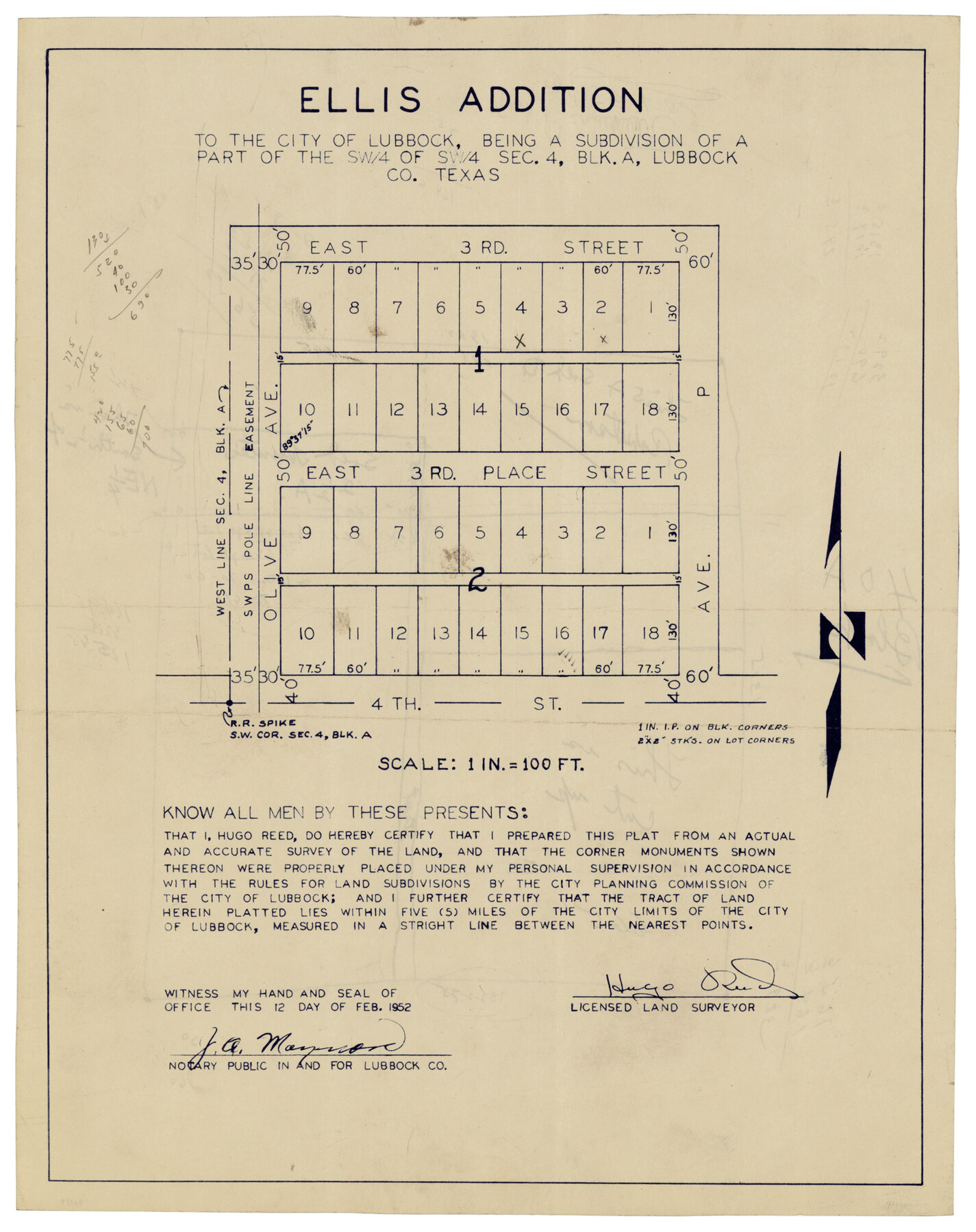
Ellis Addition to the City of Lubbock, Being a Subdivision of a Part of the SW/4 of SW/4 Sec. 4, Blk. A
-
Map/Doc
92709
-
Collection
Twichell Survey Records
-
Object Dates
2/12/1952 (Creation Date)
-
People and Organizations
Hugo Reed (Surveyor/Engineer)
-
Counties
Lubbock
-
Height x Width
9.4 x 11.9 inches
23.9 x 30.2 cm
-
Medium
blueline
-
Scale
100 feet
Part of: Twichell Survey Records
[H. & T. C. Block 47, East Line and Red River RR. Co. Block Z and vicinity]
![92974, [H. & T. C. Block 47, East Line and Red River RR. Co. Block Z and vicinity], Twichell Survey Records](https://historictexasmaps.com/wmedia_w700/maps/92974-1.tif.jpg)
Print $20.00
- Digital $50.00
[H. & T. C. Block 47, East Line and Red River RR. Co. Block Z and vicinity]
Size 17.4 x 14.0 inches
Map/Doc 92974
[W. T. Brewer: M. McDonald, Ralph Gilpin, A. Vanhooser, John Baker, John R. Taylor Surveys]
![90960, [W. T. Brewer: M. McDonald, Ralph Gilpin, A. Vanhooser, John Baker, John R. Taylor Surveys], Twichell Survey Records](https://historictexasmaps.com/wmedia_w700/maps/90960-1.tif.jpg)
Print $2.00
- Digital $50.00
[W. T. Brewer: M. McDonald, Ralph Gilpin, A. Vanhooser, John Baker, John R. Taylor Surveys]
Size 8.8 x 11.3 inches
Map/Doc 90960
[Worksheets related to the Wilson Strickland survey and vicinity]
![91283, [Worksheets related to the Wilson Strickland survey and vicinity], Twichell Survey Records](https://historictexasmaps.com/wmedia_w700/maps/91283-1.tif.jpg)
Print $20.00
- Digital $50.00
[Worksheets related to the Wilson Strickland survey and vicinity]
Size 9.9 x 29.7 inches
Map/Doc 91283
[East line of Wheeler County along Oklahoma]
![89824, [East line of Wheeler County along Oklahoma], Twichell Survey Records](https://historictexasmaps.com/wmedia_w700/maps/89824-1.tif.jpg)
Print $40.00
- Digital $50.00
[East line of Wheeler County along Oklahoma]
Size 8.4 x 62.2 inches
Map/Doc 89824
Sections 13 & 12, Block S

Print $20.00
- Digital $50.00
Sections 13 & 12, Block S
Size 23.0 x 18.2 inches
Map/Doc 92835
[Township 3 North, Block 33]
![91226, [Township 3 North, Block 33], Twichell Survey Records](https://historictexasmaps.com/wmedia_w700/maps/91226-1.tif.jpg)
Print $20.00
- Digital $50.00
[Township 3 North, Block 33]
Size 15.0 x 18.0 inches
Map/Doc 91226
![91965, [PSL Block B19], Twichell Survey Records](https://historictexasmaps.com/wmedia_w700/maps/91965-1.tif.jpg)
[H. & T. C. Block 34 and PSL Block B-19]
![91948, [H. & T. C. Block 34 and PSL Block B-19], Twichell Survey Records](https://historictexasmaps.com/wmedia_w700/maps/91948-1.tif.jpg)
Print $20.00
- Digital $50.00
[H. & T. C. Block 34 and PSL Block B-19]
Size 30.6 x 30.6 inches
Map/Doc 91948
[E. L. & R. R. Block E, Showing Mound Lake]
![91335, [E. L. & R. R. Block E, Showing Mound Lake], Twichell Survey Records](https://historictexasmaps.com/wmedia_w700/maps/91335-1.tif.jpg)
Print $2.00
- Digital $50.00
[E. L. & R. R. Block E, Showing Mound Lake]
Size 14.8 x 6.3 inches
Map/Doc 91335
Map of Blocks A, B and C in Parmer County, Texas showing a portion of the C. F. L. & I. Co's. XIT Lands

Print $20.00
- Digital $50.00
Map of Blocks A, B and C in Parmer County, Texas showing a portion of the C. F. L. & I. Co's. XIT Lands
1905
Size 24.2 x 29.4 inches
Map/Doc 91611
[East Line, Hemphill County]
![90725, [East Line, Hemphill County], Twichell Survey Records](https://historictexasmaps.com/wmedia_w700/maps/90725-1.tif.jpg)
Print $2.00
- Digital $50.00
[East Line, Hemphill County]
Size 5.4 x 15.0 inches
Map/Doc 90725
Plat of 39 7/10 Acres of Land Owned by W. D. Twichell

Print $2.00
- Digital $50.00
Plat of 39 7/10 Acres of Land Owned by W. D. Twichell
Size 7.1 x 8.1 inches
Map/Doc 92089
You may also like
General Highway Map, Mitchell County, Texas

Print $20.00
General Highway Map, Mitchell County, Texas
1940
Size 18.5 x 24.8 inches
Map/Doc 79200
Jefferson County Rolled Sketch 57

Print $20.00
- Digital $50.00
Jefferson County Rolled Sketch 57
1874
Size 25.9 x 18.6 inches
Map/Doc 6408
Flight Mission No. DCL-6C, Frame 70, Kenedy County

Print $20.00
- Digital $50.00
Flight Mission No. DCL-6C, Frame 70, Kenedy County
1943
Size 18.6 x 22.3 inches
Map/Doc 85912
Blanco County Sketch File 42

Print $20.00
- Digital $50.00
Blanco County Sketch File 42
1889
Size 13.5 x 8.8 inches
Map/Doc 14656
Crockett County Sketch File 64

Print $20.00
- Digital $50.00
Crockett County Sketch File 64
1927
Size 17.0 x 21.3 inches
Map/Doc 11229
Gaines County Rolled Sketch 33

Print $20.00
- Digital $50.00
Gaines County Rolled Sketch 33
1995
Size 17.4 x 18.2 inches
Map/Doc 76413
Panola County Working Sketch 6

Print $20.00
- Digital $50.00
Panola County Working Sketch 6
1941
Map/Doc 71415
Flight Mission No. BQR-9K, Frame 49, Brazoria County

Print $20.00
- Digital $50.00
Flight Mission No. BQR-9K, Frame 49, Brazoria County
1952
Size 18.6 x 22.3 inches
Map/Doc 84053
The Republic County of Fayette. May 3, 1838

Print $20.00
The Republic County of Fayette. May 3, 1838
2020
Size 14.7 x 21.7 inches
Map/Doc 96132
Map representing the surveys made in Bexar County

Print $40.00
- Digital $50.00
Map representing the surveys made in Bexar County
1839
Size 75.7 x 35.1 inches
Map/Doc 93365
[Sketch showing I. & G. N. Block 8]
![91715, [Sketch showing I. & G. N. Block 8], Twichell Survey Records](https://historictexasmaps.com/wmedia_w700/maps/91715-1.tif.jpg)
Print $2.00
- Digital $50.00
[Sketch showing I. & G. N. Block 8]
1919
Size 7.7 x 10.3 inches
Map/Doc 91715
Howard County Working Sketch 4

Print $20.00
- Digital $50.00
Howard County Working Sketch 4
1940
Size 21.5 x 18.3 inches
Map/Doc 66270