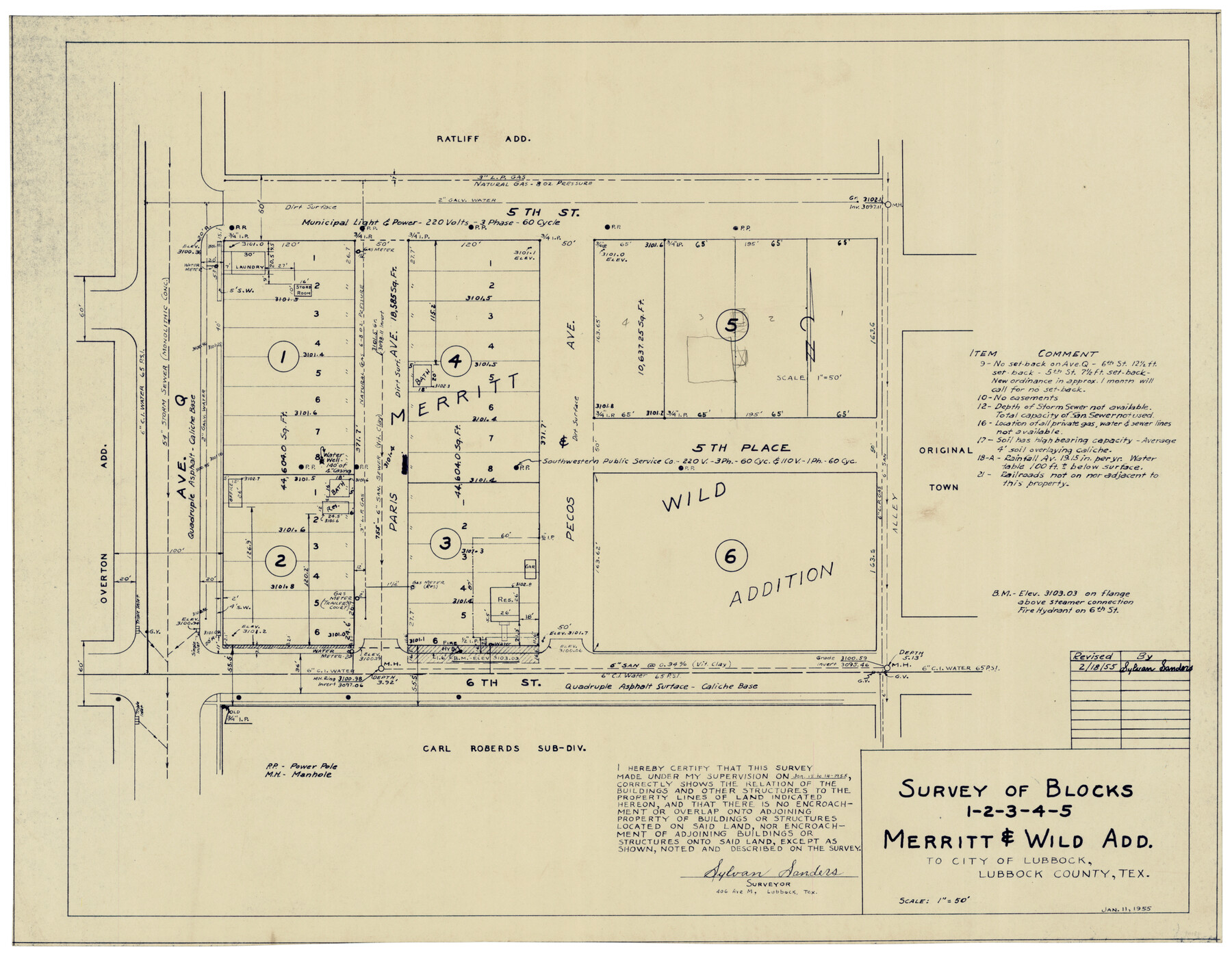
Survey of Blocks 1, 2, 3, 4, 5, Merritt and Wild Addition
-
Map/Doc
92727
-
Collection
Twichell Survey Records
-
Object Dates
1/11/1955 (Creation Date)
-
People and Organizations
Sylvan Sanders (Surveyor/Engineer)
-
Counties
Lubbock
-
Height x Width
23.5 x 18.3 inches
59.7 x 46.5 cm
Part of: Twichell Survey Records
Loving County

Print $20.00
- Digital $50.00
Loving County
1889
Size 24.6 x 19.6 inches
Map/Doc 91385
[I. & G. N. Blocks 1 and 2]
![90333, [I. & G. N. Blocks 1 and 2], Twichell Survey Records](https://historictexasmaps.com/wmedia_w700/maps/90333-1.tif.jpg)
Print $20.00
- Digital $50.00
[I. & G. N. Blocks 1 and 2]
Size 21.2 x 37.5 inches
Map/Doc 90333
[Pencil sketch around the Fred Mohler survey 19]
![92994, [Pencil sketch around the Fred Mohler survey 19], Twichell Survey Records](https://historictexasmaps.com/wmedia_w700/maps/92994-1.tif.jpg)
Print $3.00
- Digital $50.00
[Pencil sketch around the Fred Mohler survey 19]
Size 14.1 x 10.4 inches
Map/Doc 92994
Revised Map of Block "A", Parmer County

Print $20.00
- Digital $50.00
Revised Map of Block "A", Parmer County
1913
Size 21.1 x 23.9 inches
Map/Doc 91609
Surveys of Hutchins Stock Assn. Lse.

Print $20.00
- Digital $50.00
Surveys of Hutchins Stock Assn. Lse.
1929
Size 41.3 x 21.1 inches
Map/Doc 92817
Subdivision of Mallet Land and Cattle Company's Ranch Hockley, Cochran, Terry, and Yoakum Counties, Texas

Print $20.00
- Digital $50.00
Subdivision of Mallet Land and Cattle Company's Ranch Hockley, Cochran, Terry, and Yoakum Counties, Texas
Size 17.3 x 16.4 inches
Map/Doc 92207
[Sketch showing County School Land Leagues]
![90101, [Sketch showing County School Land Leagues], Twichell Survey Records](https://historictexasmaps.com/wmedia_w700/maps/90101-1.tif.jpg)
Print $3.00
- Digital $50.00
[Sketch showing County School Land Leagues]
1902
Size 11.0 x 11.1 inches
Map/Doc 90101
[Blocks C & C2]
![90747, [Blocks C & C2], Twichell Survey Records](https://historictexasmaps.com/wmedia_w700/maps/90747-1.tif.jpg)
Print $20.00
- Digital $50.00
[Blocks C & C2]
1906
Size 24.7 x 8.9 inches
Map/Doc 90747
Ellwood Corrections, Block T

Print $2.00
- Digital $50.00
Ellwood Corrections, Block T
Size 4.0 x 7.0 inches
Map/Doc 90952
Jarrott Ranch Yeso, New Mexico

Print $20.00
- Digital $50.00
Jarrott Ranch Yeso, New Mexico
Size 26.3 x 19.8 inches
Map/Doc 92423
Robertson & Scott V Ranch situated in Crosby County, Texas

Print $40.00
- Digital $50.00
Robertson & Scott V Ranch situated in Crosby County, Texas
Size 41.2 x 48.8 inches
Map/Doc 89758
[Blk. M, T. & P. Blocks 33-36, Townships 5N and 6N]
![90548, [Blk. M, T. & P. Blocks 33-36, Townships 5N and 6N], Twichell Survey Records](https://historictexasmaps.com/wmedia_w700/maps/90548-1.tif.jpg)
Print $20.00
- Digital $50.00
[Blk. M, T. & P. Blocks 33-36, Townships 5N and 6N]
Size 12.3 x 16.1 inches
Map/Doc 90548
You may also like
Jim Hogg County Rolled Sketch 14

Print $20.00
- Digital $50.00
Jim Hogg County Rolled Sketch 14
2023
Size 21.1 x 30.3 inches
Map/Doc 97155
Cottle County Sketch File 13

Print $20.00
- Digital $50.00
Cottle County Sketch File 13
1904
Size 15.8 x 15.8 inches
Map/Doc 11195
Leon County Working Sketch 55

Print $20.00
- Digital $50.00
Leon County Working Sketch 55
1989
Size 18.7 x 18.3 inches
Map/Doc 70455
Pecos County Sketch File 117

Print $4.00
- Digital $50.00
Pecos County Sketch File 117
1927
Size 10.0 x 8.8 inches
Map/Doc 34095
Eastland County Rolled Sketch 19

Print $20.00
- Digital $50.00
Eastland County Rolled Sketch 19
1980
Size 28.9 x 30.9 inches
Map/Doc 8825
Harris County Historic Topographic 3

Print $20.00
- Digital $50.00
Harris County Historic Topographic 3
1916
Size 29.4 x 22.5 inches
Map/Doc 65813
Brooks County Working Sketch 8

Print $20.00
- Digital $50.00
Brooks County Working Sketch 8
1928
Size 27.6 x 23.3 inches
Map/Doc 67792
[Map of Texas and Pacific Blocks from Brazos River westward through Palo Pinto, Stephens, Shackelford, Jones, Callahan, Taylor, Fisher, Nolan and Mitchell Counties]
![93457, [Map of Texas and Pacific Blocks from Brazos River westward through Palo Pinto, Stephens, Shackelford, Jones, Callahan, Taylor, Fisher, Nolan and Mitchell Counties], General Map Collection](https://historictexasmaps.com/wmedia_w700/maps/93457-1.tif.jpg)
Print $20.00
- Digital $50.00
[Map of Texas and Pacific Blocks from Brazos River westward through Palo Pinto, Stephens, Shackelford, Jones, Callahan, Taylor, Fisher, Nolan and Mitchell Counties]
Size 35.0 x 19.3 inches
Map/Doc 93457
Clay County Boundary File 19

Print $8.00
- Digital $50.00
Clay County Boundary File 19
1924
Size 3.3 x 5.5 inches
Map/Doc 65511
Gulf Oil Corp. Fishgide - Matagorda

Gulf Oil Corp. Fishgide - Matagorda
1960
Size 12.5 x 22.4 inches
Map/Doc 75977
Flight Mission No. DAG-22K, Frame 73, Matagorda County

Print $20.00
- Digital $50.00
Flight Mission No. DAG-22K, Frame 73, Matagorda County
1953
Size 18.7 x 22.4 inches
Map/Doc 86460
[Sketch showing surveys on the south side of the Canadian River, Blocks 4, M-3, M-19, M-20, 21-W, and Y-2]
![91740, [Sketch showing surveys on the south side of the Canadian River, Blocks 4, M-3, M-19, M-20, 21-W, and Y-2], Twichell Survey Records](https://historictexasmaps.com/wmedia_w700/maps/91740-1.tif.jpg)
Print $20.00
- Digital $50.00
[Sketch showing surveys on the south side of the Canadian River, Blocks 4, M-3, M-19, M-20, 21-W, and Y-2]
Size 43.4 x 25.1 inches
Map/Doc 91740