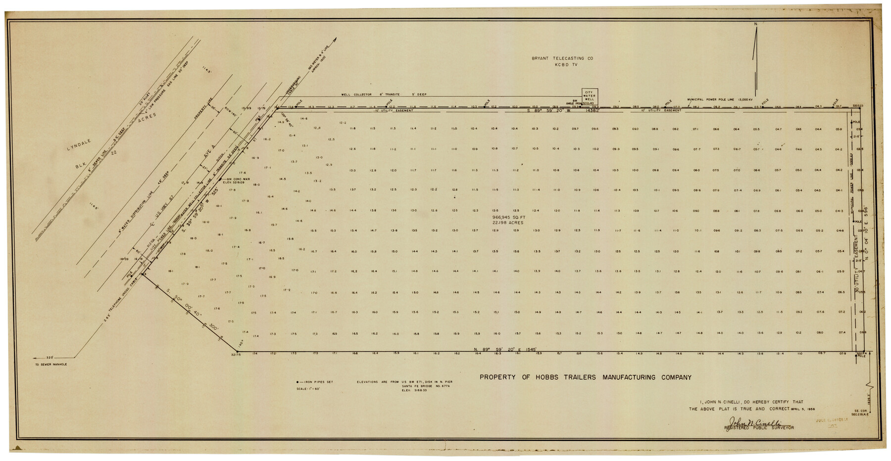
Property of Hobbs Trailers Manufacturing Company
-
Map/Doc
92733
-
Collection
Twichell Survey Records
-
Object Dates
4/5/1956 (Creation Date)
-
People and Organizations
John N. Cinelli (Surveyor/Engineer)
-
Counties
Lubbock
-
Height x Width
36.6 x 18.9 inches
93.0 x 48.0 cm
Part of: Twichell Survey Records
[Leagues 70, 71, 72, 73, 74, 75, 704, 705, 718, 719, and 732]
![91098, [Leagues 70, 71, 72, 73, 74, 75, 704, 705, 718, 719, and 732], Twichell Survey Records](https://historictexasmaps.com/wmedia_w700/maps/91098-1.tif.jpg)
Print $2.00
- Digital $50.00
[Leagues 70, 71, 72, 73, 74, 75, 704, 705, 718, 719, and 732]
Size 6.0 x 11.1 inches
Map/Doc 91098
Map of Shamrock Cemetery Located in Southwest 10 acres of Southeast 1/4 Section 43, Block 17

Print $20.00
- Digital $50.00
Map of Shamrock Cemetery Located in Southwest 10 acres of Southeast 1/4 Section 43, Block 17
Size 22.8 x 24.0 inches
Map/Doc 92134
[Sketch highlighting Bob Reid and Fred Turner surveys]
![91691, [Sketch highlighting Bob Reid and Fred Turner surveys], Twichell Survey Records](https://historictexasmaps.com/wmedia_w700/maps/91691-1.tif.jpg)
Print $3.00
- Digital $50.00
[Sketch highlighting Bob Reid and Fred Turner surveys]
Size 9.8 x 16.1 inches
Map/Doc 91691
![89832, [Yates Area], Twichell Survey Records](https://historictexasmaps.com/wmedia_w700/maps/89832-1.tif.jpg)
Working Sketch Carson County

Print $3.00
- Digital $50.00
Working Sketch Carson County
1907
Size 11.6 x 17.8 inches
Map/Doc 90224
Tascotal Mesa Quadrangle

Print $20.00
- Digital $50.00
Tascotal Mesa Quadrangle
1917
Size 17.0 x 20.7 inches
Map/Doc 90134
[Sketch of 27 1/2 Acre Tract]
![92799, [Sketch of 27 1/2 Acre Tract], Twichell Survey Records](https://historictexasmaps.com/wmedia_w700/maps/92799-1.tif.jpg)
Print $3.00
- Digital $50.00
[Sketch of 27 1/2 Acre Tract]
1940
Size 12.4 x 9.1 inches
Map/Doc 92799
De Loache's Subdivision County School Leagues Hockley County, Texas

Print $20.00
- Digital $50.00
De Loache's Subdivision County School Leagues Hockley County, Texas
1924
Size 38.6 x 36.8 inches
Map/Doc 92235
Sketch in Crockett County [showing University Land Blocks 42 and 45 and Block A-B]
![90313, Sketch in Crockett County [showing University Land Blocks 42 and 45 and Block A-B], Twichell Survey Records](https://historictexasmaps.com/wmedia_w700/maps/90313-1.tif.jpg)
Print $20.00
- Digital $50.00
Sketch in Crockett County [showing University Land Blocks 42 and 45 and Block A-B]
1913
Size 24.6 x 11.9 inches
Map/Doc 90313
Eberstadt and Brock's Subdivisions of the West Half of Survey Number 187 Block 2 A. B. & M., Randall County Texas

Print $20.00
- Digital $50.00
Eberstadt and Brock's Subdivisions of the West Half of Survey Number 187 Block 2 A. B. & M., Randall County Texas
Size 14.9 x 30.7 inches
Map/Doc 91747
[Center line of Blk. 36, T1N]
![89822, [Center line of Blk. 36, T1N], Twichell Survey Records](https://historictexasmaps.com/wmedia_w700/maps/89822-1.tif.jpg)
Print $40.00
- Digital $50.00
[Center line of Blk. 36, T1N]
1907
Size 12.6 x 69.7 inches
Map/Doc 89822
Part of Block T-2 Lamb County Texas

Print $20.00
- Digital $50.00
Part of Block T-2 Lamb County Texas
1952
Size 14.3 x 24.6 inches
Map/Doc 92182
You may also like
Concho County Sketch File X

Print $20.00
- Digital $50.00
Concho County Sketch File X
1916
Size 39.4 x 23.7 inches
Map/Doc 11168
Crockett County Sketch File 96

Print $4.00
- Digital $50.00
Crockett County Sketch File 96
1934
Size 11.4 x 8.9 inches
Map/Doc 19964
San Antonio of the 17th, 18th, and 19th Centuries: A Chronology of Her Romantic Past

San Antonio of the 17th, 18th, and 19th Centuries: A Chronology of Her Romantic Past
1929
Size 8.1 x 5.1 inches
Map/Doc 97044
Preliminary map of Brazos Island

Print $20.00
- Digital $50.00
Preliminary map of Brazos Island
1863
Size 25.2 x 18.1 inches
Map/Doc 72924
Webb County Rolled Sketch 62

Print $20.00
- Digital $50.00
Webb County Rolled Sketch 62
1947
Size 25.2 x 27.4 inches
Map/Doc 8212
Dallam County

Print $20.00
- Digital $50.00
Dallam County
1888
Size 29.5 x 24.6 inches
Map/Doc 90654
Rio Grande, Penitas Sheet

Print $20.00
- Digital $50.00
Rio Grande, Penitas Sheet
1937
Size 39.8 x 42.0 inches
Map/Doc 69708
Section E Tech Memorial Park, Inc.

Print $20.00
- Digital $50.00
Section E Tech Memorial Park, Inc.
Size 30.9 x 19.1 inches
Map/Doc 92301
Scurry County Sketch File 4

Print $26.00
- Digital $50.00
Scurry County Sketch File 4
1881
Size 13.1 x 8.5 inches
Map/Doc 36565
Pecos County Working Sketch 56

Print $40.00
- Digital $50.00
Pecos County Working Sketch 56
1949
Size 29.9 x 57.4 inches
Map/Doc 71528
Flight Mission No. CRE-2R, Frame 84, Jackson County

Print $20.00
- Digital $50.00
Flight Mission No. CRE-2R, Frame 84, Jackson County
1956
Size 16.1 x 15.9 inches
Map/Doc 85356
The Judicial District/County of Neches. Created, January 29, 1842

Print $20.00
The Judicial District/County of Neches. Created, January 29, 1842
2020
Size 15.5 x 21.7 inches
Map/Doc 96338