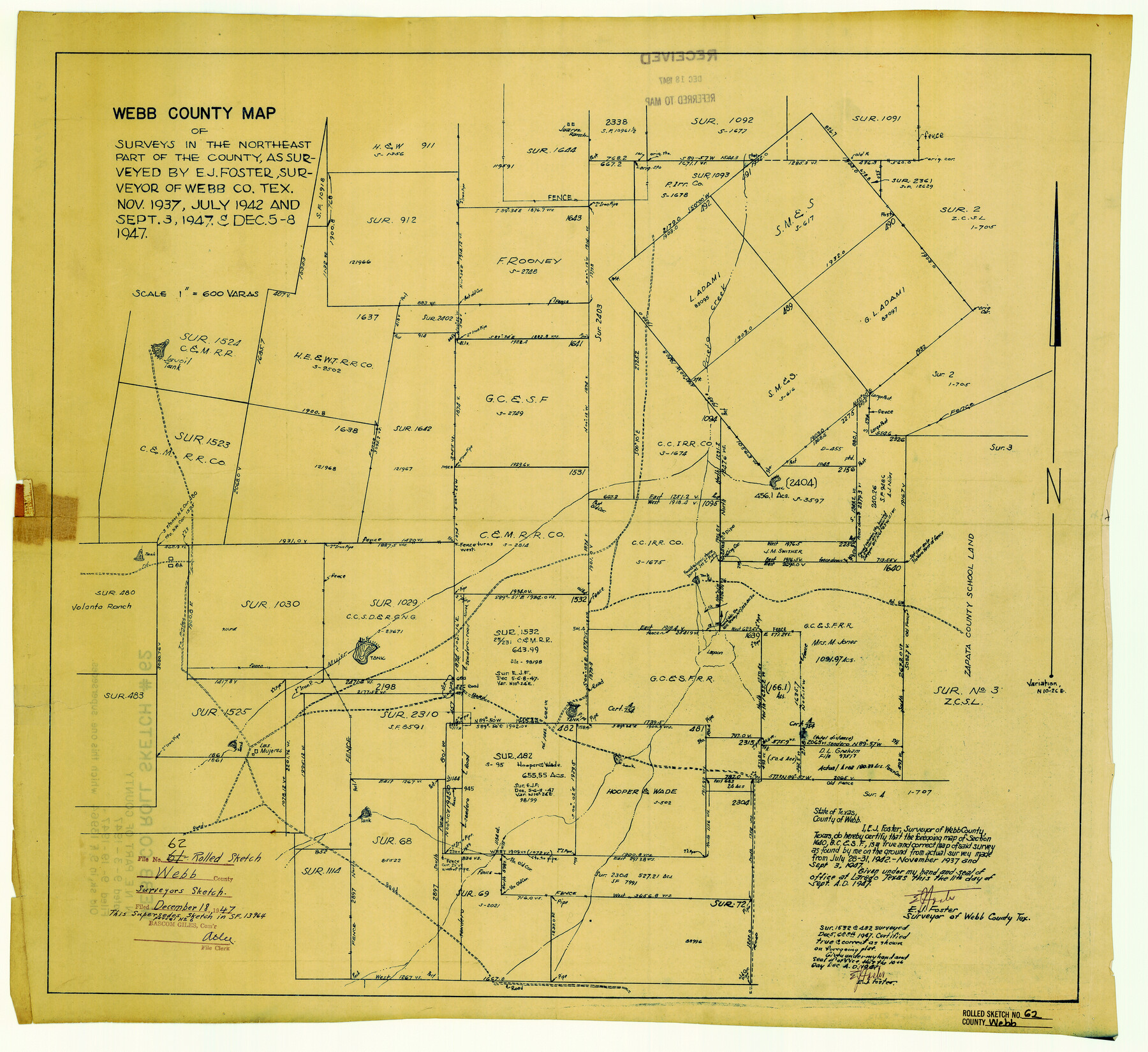
Webb County Rolled Sketch 62
Webb County map of surveys in the northeast part of the county
-
Map/Doc
8212
-
Collection
General Map Collection
-
Object Dates
1947/9/3 (Survey Date)
1947/12/18 (File Date)
1947/9/11 (Creation Date)
1947/12/10 (Revision Date)
-
People and Organizations
E.J. Foster (Surveyor/Engineer)
-
Counties
Webb
-
Subjects
Surveying Rolled Sketch
-
Height x Width
25.2 x 27.4 inches
64.0 x 69.6 cm
-
Medium
blueprint/diazo
-
Scale
1" = 600 varas
Part of: General Map Collection

List of County School Lands

Print $20.00
- Digital $50.00
List of County School Lands
Size 17.7 x 23.2 inches
Map/Doc 65797
Rusk County Sketch File 44

Print $12.00
Rusk County Sketch File 44
1951
Size 11.3 x 8.9 inches
Map/Doc 35585
Hutchinson County Rolled Sketch 43

Print $40.00
- Digital $50.00
Hutchinson County Rolled Sketch 43
1992
Size 41.3 x 50.0 inches
Map/Doc 6314
Lamb County Rolled Sketch 3

Print $20.00
- Digital $50.00
Lamb County Rolled Sketch 3
1917
Size 23.0 x 42.5 inches
Map/Doc 9413
Flight Mission No. DCL-5C, Frame 73, Kenedy County

Print $20.00
- Digital $50.00
Flight Mission No. DCL-5C, Frame 73, Kenedy County
1943
Size 18.5 x 22.2 inches
Map/Doc 85856
Reeves County Working Sketch 38

Print $20.00
- Digital $50.00
Reeves County Working Sketch 38
1971
Size 36.4 x 39.0 inches
Map/Doc 63481
Hays County Working Sketch 23

Print $20.00
- Digital $50.00
Hays County Working Sketch 23
2011
Size 30.5 x 29.2 inches
Map/Doc 90090
Flight Mission No. DCL-7C, Frame 17, Kenedy County

Print $20.00
- Digital $50.00
Flight Mission No. DCL-7C, Frame 17, Kenedy County
1943
Size 15.3 x 15.2 inches
Map/Doc 86009
Kerr County Rolled Sketch 25

Print $20.00
- Digital $50.00
Kerr County Rolled Sketch 25
Size 24.7 x 31.0 inches
Map/Doc 6505
Young County Sketch File 16

Print $4.00
- Digital $50.00
Young County Sketch File 16
1896
Size 10.3 x 8.5 inches
Map/Doc 40880
Burnet County Working Sketch 14

Print $20.00
- Digital $50.00
Burnet County Working Sketch 14
1978
Size 37.0 x 38.5 inches
Map/Doc 67857
You may also like
Flight Mission No. BQR-4K, Frame 61, Brazoria County

Print $20.00
- Digital $50.00
Flight Mission No. BQR-4K, Frame 61, Brazoria County
1952
Size 18.7 x 22.5 inches
Map/Doc 83994
Kinney County Sketch File 18

Print $20.00
- Digital $50.00
Kinney County Sketch File 18
Size 29.0 x 25.2 inches
Map/Doc 11943

Map of Lee County

Print $20.00
- Digital $50.00
Map of Lee County
1888
Size 42.1 x 39.8 inches
Map/Doc 16876
Crockett County Sketch File 47

Print $6.00
- Digital $50.00
Crockett County Sketch File 47
1882
Size 14.3 x 8.8 inches
Map/Doc 19789
Zavalla County

Print $20.00
- Digital $50.00
Zavalla County
1879
Size 21.3 x 25.0 inches
Map/Doc 4645
Carson County Sketch File 5

Print $28.00
- Digital $50.00
Carson County Sketch File 5
1916
Size 7.5 x 8.7 inches
Map/Doc 17353
Denton County Working Sketch 1

Print $20.00
- Digital $50.00
Denton County Working Sketch 1
1920
Size 16.1 x 12.9 inches
Map/Doc 68606
Reeves County Rolled Sketch 39

Print $20.00
- Digital $50.00
Reeves County Rolled Sketch 39
2018
Size 25.0 x 36.5 inches
Map/Doc 96570
Angelina County Working Sketch 58

Print $20.00
- Digital $50.00
Angelina County Working Sketch 58
2006
Size 24.1 x 36.0 inches
Map/Doc 83608

Texas-Indian Territory Gainesville Quadrangle

Print $20.00
- Digital $50.00
Texas-Indian Territory Gainesville Quadrangle
1902
Size 20.4 x 16.9 inches
Map/Doc 75102