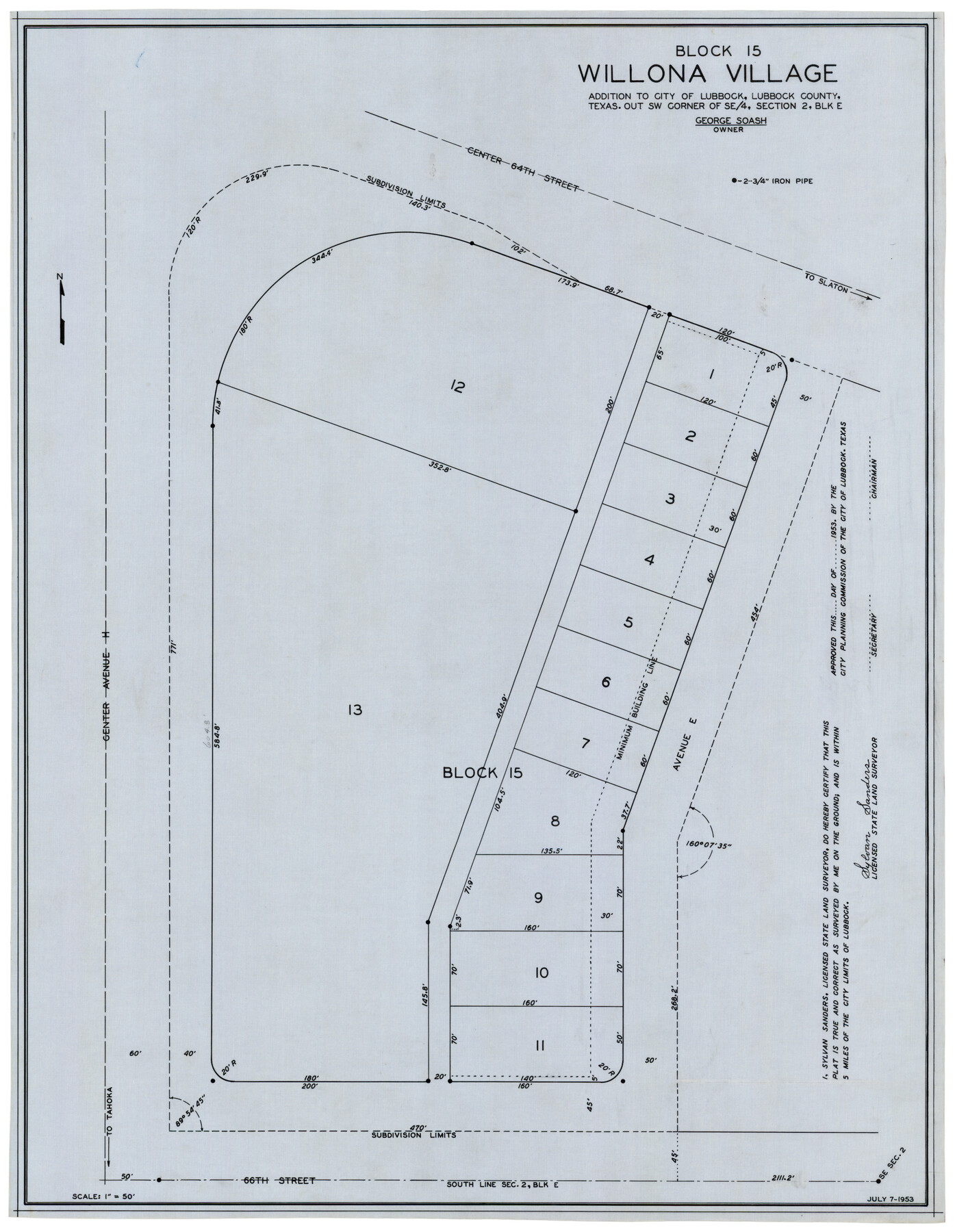
Block 15, Willona Village, Addition to City of Lubbock, Out SW Corner of SE/4, Section 2, Blk E, George Soash, Owner
-
Map/Doc
92772
-
Collection
Twichell Survey Records
-
Object Dates
7/7/1953 (Creation Date)
-
People and Organizations
Sylvan Sanders (Surveyor/Engineer)
-
Counties
Lubbock
-
Height x Width
18.2 x 23.1 inches
46.2 x 58.7 cm
Part of: Twichell Survey Records
Double Lakes No. 1, T-Ranch

Print $20.00
- Digital $50.00
Double Lakes No. 1, T-Ranch
Size 37.1 x 34.0 inches
Map/Doc 92944
[Texas Boundary Line]
![92075, [Texas Boundary Line], Twichell Survey Records](https://historictexasmaps.com/wmedia_w700/maps/92075-1.tif.jpg)
Print $20.00
- Digital $50.00
[Texas Boundary Line]
Size 21.4 x 11.9 inches
Map/Doc 92075
[Area north of League 1, Morris County School Land]
![90351, [Area north of League 1, Morris County School Land], Twichell Survey Records](https://historictexasmaps.com/wmedia_w700/maps/90351-1.tif.jpg)
Print $20.00
- Digital $50.00
[Area north of League 1, Morris County School Land]
Size 12.9 x 14.1 inches
Map/Doc 90351
[Corner of Blocks H1, K5, Z3, S, and Block 8]
![91470, [Corner of Blocks H1, K5, Z3, S, and Block 8], Twichell Survey Records](https://historictexasmaps.com/wmedia_w700/maps/91470-1.tif.jpg)
Print $3.00
- Digital $50.00
[Corner of Blocks H1, K5, Z3, S, and Block 8]
Size 11.9 x 14.6 inches
Map/Doc 91470
J. B. McCauley Farm Section 17, Block AK

Print $20.00
- Digital $50.00
J. B. McCauley Farm Section 17, Block AK
Size 22.9 x 27.3 inches
Map/Doc 92297

[H. & T. C. RR. Company, Block 47 and Vicinity]
![91413, [H. & T. C. RR. Company, Block 47 and Vicinity], Twichell Survey Records](https://historictexasmaps.com/wmedia_w700/maps/91413-1.tif.jpg)
Print $20.00
- Digital $50.00
[H. & T. C. RR. Company, Block 47 and Vicinity]
Size 18.8 x 13.6 inches
Map/Doc 91413
[Pencil sketch showing triangulation from Flag on Mouth of Clear Fork and Top Hill]
![92088, [Pencil sketch showing triangulation from Flag on Mouth of Clear Fork and Top Hill], Twichell Survey Records](https://historictexasmaps.com/wmedia_w700/maps/92088-1.tif.jpg)
Print $20.00
- Digital $50.00
[Pencil sketch showing triangulation from Flag on Mouth of Clear Fork and Top Hill]
Size 19.5 x 12.5 inches
Map/Doc 92088
[Map showing State Capitol Lands]
![93145, [Map showing State Capitol Lands], Twichell Survey Records](https://historictexasmaps.com/wmedia_w700/maps/93145-1.tif.jpg)
Print $40.00
- Digital $50.00
[Map showing State Capitol Lands]
Size 50.9 x 65.8 inches
Map/Doc 93145
[Rockwall County School Land and adjacent Blocks]
![90759, [Rockwall County School Land and adjacent Blocks], Twichell Survey Records](https://historictexasmaps.com/wmedia_w700/maps/90759-1.tif.jpg)
Print $20.00
- Digital $50.00
[Rockwall County School Land and adjacent Blocks]
1904
Size 16.2 x 12.6 inches
Map/Doc 90759
[Portion of R. M. Thompson Blocks 1 and 2]
![91122, [Portion of R. M. Thompson Blocks 1 and 2], Twichell Survey Records](https://historictexasmaps.com/wmedia_w700/maps/91122-1.tif.jpg)
Print $3.00
- Digital $50.00
[Portion of R. M. Thompson Blocks 1 and 2]
Size 9.5 x 11.7 inches
Map/Doc 91122
[PSL Block A-12]
![93230, [PSL Block A-12], Twichell Survey Records](https://historictexasmaps.com/wmedia_w700/maps/93230-1.tif.jpg)
Print $20.00
- Digital $50.00
[PSL Block A-12]
Size 23.8 x 20.3 inches
Map/Doc 93230
You may also like
Sutton County Working Sketch 29

Print $20.00
- Digital $50.00
Sutton County Working Sketch 29
1917
Size 15.8 x 13.6 inches
Map/Doc 62372
Plat of Division 3 of Day Ranch Lands, Leaday, Texas

Print $20.00
- Digital $50.00
Plat of Division 3 of Day Ranch Lands, Leaday, Texas
Size 20.4 x 21.8 inches
Map/Doc 81514
Young County Working Sketch 8

Print $20.00
- Digital $50.00
Young County Working Sketch 8
1920
Size 17.3 x 12.6 inches
Map/Doc 62031
Montgomery County Sketch File 13

Print $40.00
- Digital $50.00
Montgomery County Sketch File 13
1900
Size 17.8 x 14.8 inches
Map/Doc 31803
Chambers County Boundary File 1

Print $28.00
- Digital $50.00
Chambers County Boundary File 1
Size 8.9 x 6.7 inches
Map/Doc 51226
Jeff Davis County Rolled Sketch 26

Print $20.00
- Digital $50.00
Jeff Davis County Rolled Sketch 26
1957
Size 25.1 x 42.3 inches
Map/Doc 6374
[Map of the Location Survey of the Hearne & Brazos Valley Railroad]
![64348, [Map of the Location Survey of the Hearne & Brazos Valley Railroad], General Map Collection](https://historictexasmaps.com/wmedia_w700/maps/64348.tif.jpg)
Print $40.00
- Digital $50.00
[Map of the Location Survey of the Hearne & Brazos Valley Railroad]
1891
Size 38.4 x 65.1 inches
Map/Doc 64348
The Republic County of Houston. January 30, 1841

Print $20.00
The Republic County of Houston. January 30, 1841
2020
Size 19.7 x 21.8 inches
Map/Doc 96179
General Highway Map, Live Oak County, Texas

Print $20.00
General Highway Map, Live Oak County, Texas
1961
Size 18.3 x 24.8 inches
Map/Doc 79575
Liberty County Sketch File 41

Print $2.00
- Digital $50.00
Liberty County Sketch File 41
1872
Size 12.5 x 8.5 inches
Map/Doc 29997
Rio Grande Rectification Project, El Paso and Juarez Valley

Print $20.00
- Digital $50.00
Rio Grande Rectification Project, El Paso and Juarez Valley
1935
Size 10.7 x 29.6 inches
Map/Doc 60865
Terrell County Working Sketch 50

Print $40.00
- Digital $50.00
Terrell County Working Sketch 50
1958
Size 43.0 x 64.3 inches
Map/Doc 62143