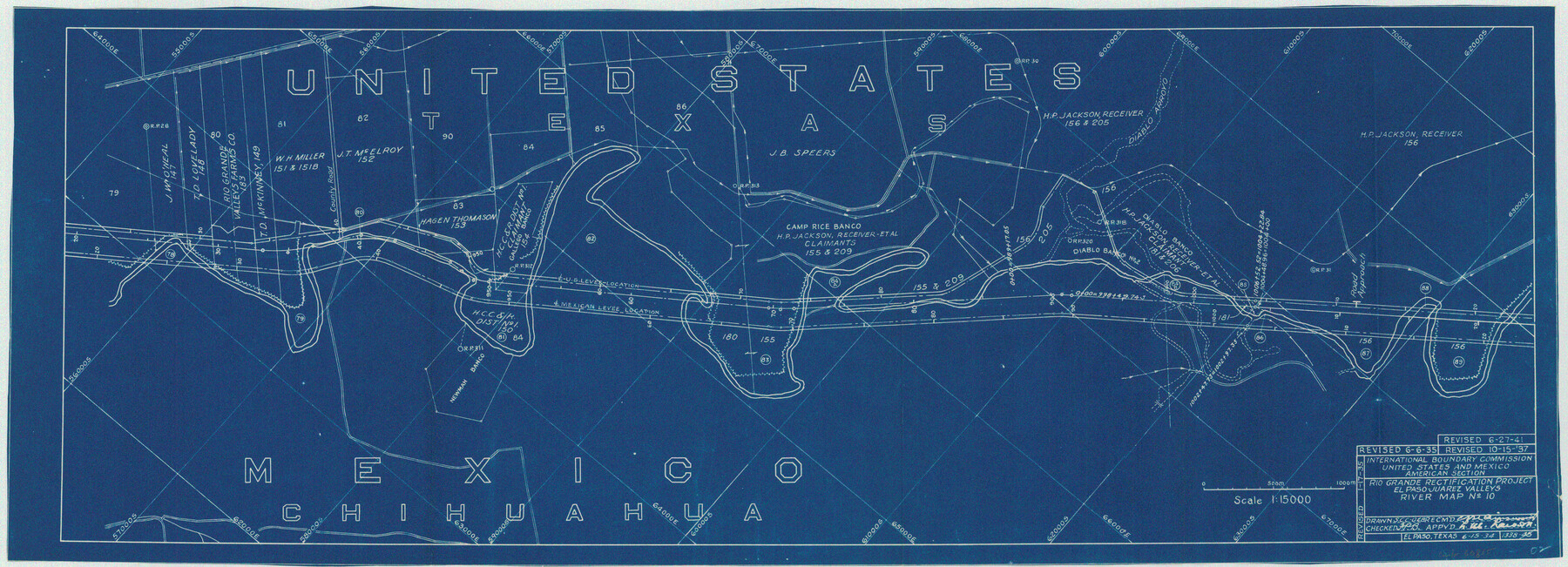
Rio Grande Rectification Project, El Paso and Juarez Valley
Rio Grande from El Paso-Hudspeth Co. line east to about Quitman Canyon
N-1-9
-
Map/Doc
60865
-
Collection
General Map Collection
-
Object Dates
1935 (Creation Date)
-
Subjects
River Surveys Texas Boundaries
-
Height x Width
10.7 x 29.6 inches
27.2 x 75.2 cm
Part of: General Map Collection
[Surveys in Austin's Colony along the San Bernardo River from the mouth of Peach Creek]
![209, [Surveys in Austin's Colony along the San Bernardo River from the mouth of Peach Creek], General Map Collection](https://historictexasmaps.com/wmedia_w700/maps/209.tif.jpg)
Print $20.00
- Digital $50.00
[Surveys in Austin's Colony along the San Bernardo River from the mouth of Peach Creek]
1821
Size 23.4 x 10.6 inches
Map/Doc 209
Topographical Map of the Rio Grande, Sheet No. 20

Print $20.00
- Digital $50.00
Topographical Map of the Rio Grande, Sheet No. 20
1912
Map/Doc 89544
Tom Green County Sketch File 46

Print $82.00
- Digital $50.00
Tom Green County Sketch File 46
1883
Size 28.4 x 28.6 inches
Map/Doc 10402
Eastland County Working Sketch 3

Print $20.00
- Digital $50.00
Eastland County Working Sketch 3
1917
Size 16.5 x 20.2 inches
Map/Doc 68784
Gregg County Rolled Sketch 27

Print $137.00
- Digital $50.00
Gregg County Rolled Sketch 27
1933
Size 10.4 x 15.3 inches
Map/Doc 45625
Edwards County Working Sketch 25

Print $20.00
- Digital $50.00
Edwards County Working Sketch 25
1942
Size 22.6 x 20.8 inches
Map/Doc 68901
Flight Mission No. BRE-1P, Frame 103, Nueces County

Print $20.00
- Digital $50.00
Flight Mission No. BRE-1P, Frame 103, Nueces County
1956
Size 18.4 x 22.2 inches
Map/Doc 86674
J No. 4 - Reconnaissance of Catalina Harbor And the Anchorage on the N.E. Side of the Island, California

Print $20.00
- Digital $50.00
J No. 4 - Reconnaissance of Catalina Harbor And the Anchorage on the N.E. Side of the Island, California
1852
Size 18.3 x 13.1 inches
Map/Doc 97231
Ector County Working Sketch 14

Print $40.00
- Digital $50.00
Ector County Working Sketch 14
1955
Size 72.7 x 43.4 inches
Map/Doc 68857
Hall County Rolled Sketch 7

Print $20.00
- Digital $50.00
Hall County Rolled Sketch 7
Size 9.2 x 26.4 inches
Map/Doc 6051
[Sketch for Mineral Application 13440]
![2799, [Sketch for Mineral Application 13440], General Map Collection](https://historictexasmaps.com/wmedia_w700/maps/2799-1.tif.jpg)
Print $20.00
- Digital $50.00
[Sketch for Mineral Application 13440]
1925
Size 24.3 x 54.0 inches
Map/Doc 2799
Outer Continental Shelf Leasing Maps (Texas Offshore Operations)

Print $20.00
- Digital $50.00
Outer Continental Shelf Leasing Maps (Texas Offshore Operations)
Size 24.3 x 18.5 inches
Map/Doc 75851
You may also like
Pecos County Rolled Sketch 26A

Print $40.00
- Digital $50.00
Pecos County Rolled Sketch 26A
1890
Size 19.0 x 55.5 inches
Map/Doc 75934
Tom Green County Sketch File 82

Print $20.00
- Digital $50.00
Tom Green County Sketch File 82
1888
Size 18.5 x 20.9 inches
Map/Doc 12454
Tyler County Rolled Sketch 2

Print $20.00
- Digital $50.00
Tyler County Rolled Sketch 2
1944
Size 29.6 x 17.4 inches
Map/Doc 8056
Pecos County Working Sketch 120

Print $20.00
- Digital $50.00
Pecos County Working Sketch 120
1973
Size 34.7 x 29.1 inches
Map/Doc 71593
Colorado County Sketch File 5

Print $4.00
- Digital $50.00
Colorado County Sketch File 5
Size 12.5 x 8.3 inches
Map/Doc 18919

Flight Mission No. CUG-1P, Frame 111, Kleberg County

Print $20.00
- Digital $50.00
Flight Mission No. CUG-1P, Frame 111, Kleberg County
1956
Size 18.5 x 22.2 inches
Map/Doc 86161

Texas-Oklahoma Paris Quadrangle

Print $20.00
- Digital $50.00
Texas-Oklahoma Paris Quadrangle
Size 22.3 x 18.4 inches
Map/Doc 75107
Map of Travis County

Print $40.00
- Digital $50.00
Map of Travis County
1895
Size 48.8 x 54.1 inches
Map/Doc 82083
Polk County Sketch File 5

Print $2.00
- Digital $50.00
Polk County Sketch File 5
Size 8.0 x 7.0 inches
Map/Doc 34128
Flight Mission No. CLL-3N, Frame 11, Willacy County

Print $20.00
- Digital $50.00
Flight Mission No. CLL-3N, Frame 11, Willacy County
1954
Size 18.6 x 22.3 inches
Map/Doc 87077