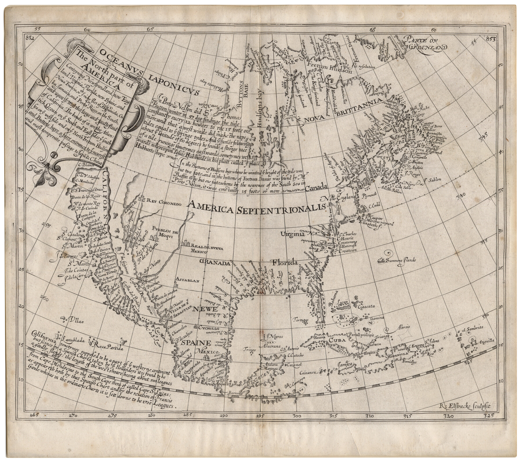
The North Part of America
-
Map/Doc
93815
-
Collection
Holcomb Map Collection
-
Object Dates
1625 (Creation Date)
-
People and Organizations
Henry Briggs (Author)
-
Subjects
North America
-
Height x Width
13.1 x 14.8 inches
33.3 x 37.6 cm
-
Comments
Courtesy of Frank and Carol Holcomb.
Part of: Holcomb Map Collection
Texas Nach den besten Quellen

Print $20.00
- Digital $50.00
Texas Nach den besten Quellen
1846
Size 15.4 x 18.7 inches
Map/Doc 93874
Map of Texas and the Countries Adjacent compiled in the Bureau of the Corps of Topographical Engineers from the Best Authorities

Print $20.00
- Digital $50.00
Map of Texas and the Countries Adjacent compiled in the Bureau of the Corps of Topographical Engineers from the Best Authorities
1844
Size 22.3 x 33.4 inches
Map/Doc 93867
Colton's New Map of the State of Texas, the Indian Territory and adjoining portions of New Mexico, Louisiana and Arkansas

Print $20.00
- Digital $50.00
Colton's New Map of the State of Texas, the Indian Territory and adjoining portions of New Mexico, Louisiana and Arkansas
1882
Size 32.8 x 37.3 inches
Map/Doc 93909
Trace d'une partie Chemin de Fer de Galveston à Houston et Henderson, Texas, Etats unis d'Amérique

Print $20.00
- Digital $50.00
Trace d'une partie Chemin de Fer de Galveston à Houston et Henderson, Texas, Etats unis d'Amérique
1857
Size 17.1 x 21.8 inches
Map/Doc 93905
A Map of the United States of Mexico as organized and defined by the several Acts of the Congress of that Republic

Print $20.00
- Digital $50.00
A Map of the United States of Mexico as organized and defined by the several Acts of the Congress of that Republic
1847
Size 24.3 x 30.6 inches
Map/Doc 93876
America with those known parts in that unknowne worlde both people and manner of buildings

Print $20.00
- Digital $50.00
America with those known parts in that unknowne worlde both people and manner of buildings
1626
Size 17.2 x 22.3 inches
Map/Doc 93830
Traveller's Map of the State of Texas

Print $20.00
- Digital $50.00
Traveller's Map of the State of Texas
1867
Size 43.4 x 41.6 inches
Map/Doc 93906
America siue India Nova ad magnae Gerardi Mercatoris aui Vniversalis imitationem in compendium redacta

Print $20.00
- Digital $50.00
America siue India Nova ad magnae Gerardi Mercatoris aui Vniversalis imitationem in compendium redacta
1595
Size 18.3 x 21.6 inches
Map/Doc 93807
The State of Texas

Print $20.00
- Digital $50.00
The State of Texas
1845
Size 18.9 x 23.2 inches
Map/Doc 93870
A New Map of Texas, Oregon and California with the regions adjoining, compiled from the most recent authorities

Print $20.00
- Digital $50.00
A New Map of Texas, Oregon and California with the regions adjoining, compiled from the most recent authorities
1846
Size 23.2 x 21.2 inches
Map/Doc 93872
Genl. Austins Map of Texas With Parts of the Adjoining States

Print $20.00
- Digital $50.00
Genl. Austins Map of Texas With Parts of the Adjoining States
1840
Size 30.6 x 25.3 inches
Map/Doc 93860
A Map of North America, constructed according to the latest information

Print $40.00
- Digital $50.00
A Map of North America, constructed according to the latest information
1822
Size 44.4 x 59.6 inches
Map/Doc 93845
You may also like
San Felipe Town Tract & Adjoining Survey for S. F. Austin and A. Lester

Print $2.00
- Digital $50.00
San Felipe Town Tract & Adjoining Survey for S. F. Austin and A. Lester
Size 9.9 x 8.1 inches
Map/Doc 78368
Bowie County Sketch File 8b

Print $6.00
- Digital $50.00
Bowie County Sketch File 8b
1927
Size 6.2 x 9.9 inches
Map/Doc 14875
Ellis County Working Sketch 4

Print $40.00
- Digital $50.00
Ellis County Working Sketch 4
1997
Size 48.0 x 30.3 inches
Map/Doc 69020
Scurry County Sketch Mineral Application No. 42315

Print $20.00
- Digital $50.00
Scurry County Sketch Mineral Application No. 42315
1950
Size 24.0 x 16.5 inches
Map/Doc 92965
Coast Chart No. 210 Aransas Pass and Corpus Christi Bay with the coast to latitude 27° 12' Texas

Print $20.00
- Digital $50.00
Coast Chart No. 210 Aransas Pass and Corpus Christi Bay with the coast to latitude 27° 12' Texas
1887
Size 27.1 x 18.5 inches
Map/Doc 72788
Garza County Sketch File 28

Print $6.00
- Digital $50.00
Garza County Sketch File 28
1935
Size 11.2 x 8.8 inches
Map/Doc 24097
Montgomery County Working Sketch 4

Print $20.00
- Digital $50.00
Montgomery County Working Sketch 4
1926
Size 20.9 x 22.2 inches
Map/Doc 71110
Entrance to Sabine Pass, Texas from survey of May and June 1892 under the direction of Major James B. Quinn, Corps of Engineers, USA

Print $20.00
- Digital $50.00
Entrance to Sabine Pass, Texas from survey of May and June 1892 under the direction of Major James B. Quinn, Corps of Engineers, USA
1892
Size 18.8 x 32.9 inches
Map/Doc 94154
Burnet County Sketch File 36

Print $60.00
- Digital $50.00
Burnet County Sketch File 36
1935
Size 25.7 x 17.6 inches
Map/Doc 11025
Willacy County Working Sketch Graphic Index

Print $20.00
- Digital $50.00
Willacy County Working Sketch Graphic Index
1921
Size 32.8 x 32.7 inches
Map/Doc 76741
Map of Bowie County

Print $20.00
- Digital $50.00
Map of Bowie County
1884
Size 19.4 x 23.7 inches
Map/Doc 3319
Stonewall County Sketch File B1

Print $20.00
- Digital $50.00
Stonewall County Sketch File B1
1901
Size 36.2 x 34.9 inches
Map/Doc 10379