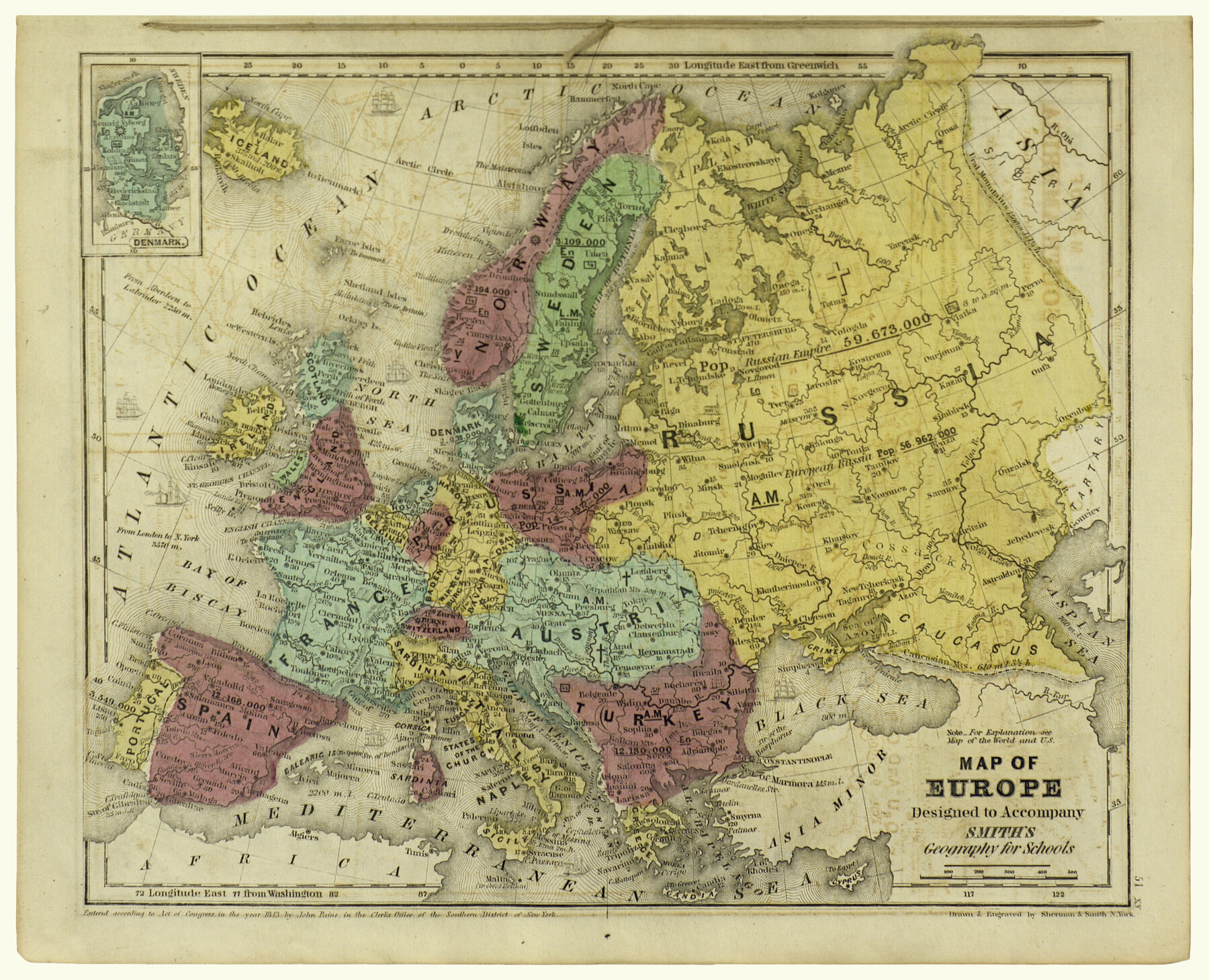
Map of Europe designed to accompany Smith's Geography for Schools
-
Map/Doc
93892
-
Collection
Holcomb Digital Map Collection
-
Object Dates
1850 (Creation Date)
-
People and Organizations
Sherman and Smith (Printer)
Sherman and Smith (Draftsman)
-
Subjects
Atlas Europe
-
Height x Width
9.8 x 12.1 inches
24.9 x 30.7 cm
-
Comments
Courtesy of Frank and Carol Holcomb.
Part of: Holcomb Digital Map Collection
Map and Description of Texas, containing sketches of its history, geology, geography and statistics: with concise statements, relative to the soil, climate, productions, facilities of transportation, population of the country;

Print $324.00
- Digital $50.00
Map and Description of Texas, containing sketches of its history, geology, geography and statistics: with concise statements, relative to the soil, climate, productions, facilities of transportation, population of the country;
1840
Size 6.1 x 4.1 inches
Map/Doc 93861
A.R. Roessler's Latest Map of the State of Texas Exhibiting Mineral and Agricultural Districts, Post Offices & Mailroutes, Railroads projected and finished, Timber, Prairie, Swamp Lands, etc. etc. etc.

Print $20.00
- Digital $50.00
A.R. Roessler's Latest Map of the State of Texas Exhibiting Mineral and Agricultural Districts, Post Offices & Mailroutes, Railroads projected and finished, Timber, Prairie, Swamp Lands, etc. etc. etc.
1874
Size 39.9 x 44.6 inches
Map/Doc 95369

Map of Texas compiled from surveys recorded in the Land Office of Texas, and other official surveys

Print $20.00
- Digital $50.00
Map of Texas compiled from surveys recorded in the Land Office of Texas, and other official surveys
1843
Size 27.1 x 22.5 inches
Map/Doc 93863
Bowles's New Pocket Map of America divided into its Provinces, Colonies, States, Governments &c. exhibiting the British and Spanish Empires therein; together with the Territories belonging to the French, Dutch, Danes & Portuguese

Print $20.00
- Digital $50.00
Bowles's New Pocket Map of America divided into its Provinces, Colonies, States, Governments &c. exhibiting the British and Spanish Empires therein; together with the Territories belonging to the French, Dutch, Danes & Portuguese
1784
Size 21.3 x 23.1 inches
Map/Doc 93838
Nova et Acurata Totius Americae Tabula

Print $40.00
Nova et Acurata Totius Americae Tabula
1608
Size 40.8 x 56.5 inches
Map/Doc 97019
The History of the Republic of Texas, from the discovery of the country to the present time; and the cause of her separation from the Republic of Mexico.

Print $1080.00
- Digital $50.00
The History of the Republic of Texas, from the discovery of the country to the present time; and the cause of her separation from the Republic of Mexico.
1842
Size 9.3 x 6.1 inches
Map/Doc 93866
Americae Pars Borealis, Florida, Baccalaos, Canada, Corterealis

Print $20.00
- Digital $50.00
Americae Pars Borealis, Florida, Baccalaos, Canada, Corterealis
1593
Size 16.2 x 22.1 inches
Map/Doc 93832
Map of the British Isles designed to accompany Smith's Geography for Schools

Print $20.00
- Digital $50.00
Map of the British Isles designed to accompany Smith's Geography for Schools
1850
Size 12.1 x 9.8 inches
Map/Doc 93894
Nuevo Mapa Geographico de la America Septentrional, Perteneciente al Virreynato de Mexico

Print $20.00
- Digital $50.00
Nuevo Mapa Geographico de la America Septentrional, Perteneciente al Virreynato de Mexico
1768
Size 23.1 x 30.3 inches
Map/Doc 93835
Map of the Colonization Grants to Zavala, Vehlein & Burnet in Texas, belonging to the Galveston Bay & Texas Land Co.

Print $20.00
- Digital $50.00
Map of the Colonization Grants to Zavala, Vehlein & Burnet in Texas, belonging to the Galveston Bay & Texas Land Co.
1835
Size 10.7 x 12.7 inches
Map/Doc 93851
A Map of North America, constructed according to the latest information

Print $40.00
- Digital $50.00
A Map of North America, constructed according to the latest information
1822
Size 44.4 x 59.6 inches
Map/Doc 93845
You may also like
Menard County Working Sketch 1

Print $20.00
- Digital $50.00
Menard County Working Sketch 1
1905
Size 23.3 x 18.9 inches
Map/Doc 70948

University Land Field Notes for Blocks 34 through 37 in Terrell County

University Land Field Notes for Blocks 34 through 37 in Terrell County
Map/Doc 81720
Flight Mission No. DQN-2K, Frame 71, Calhoun County

Print $20.00
- Digital $50.00
Flight Mission No. DQN-2K, Frame 71, Calhoun County
1953
Size 18.9 x 22.4 inches
Map/Doc 84263
Wellman Situated on Parts of the Northeast 1/4 and Northwest 1/4 Section 17, Block DD

Print $20.00
- Digital $50.00
Wellman Situated on Parts of the Northeast 1/4 and Northwest 1/4 Section 17, Block DD
Size 22.2 x 18.9 inches
Map/Doc 92930

Cottle County Working Sketch 3

Print $20.00
- Digital $50.00
Cottle County Working Sketch 3
1900
Size 13.6 x 11.4 inches
Map/Doc 68313
Potter County

Print $20.00
- Digital $50.00
Potter County
1960
Size 42.6 x 34.6 inches
Map/Doc 66985
[Blk. O1, W. H. Godair]
![90632, [Blk. O1, W. H. Godair], Twichell Survey Records](https://historictexasmaps.com/wmedia_w700/maps/90632-1.tif.jpg)
Print $20.00
- Digital $50.00
[Blk. O1, W. H. Godair]
1913
Size 30.1 x 10.3 inches
Map/Doc 90632
Terrell County Rolled Sketch 25

Print $20.00
- Digital $50.00
Terrell County Rolled Sketch 25
1911
Size 15.7 x 22.7 inches
Map/Doc 7932
Presidio County Sketch File 111

Print $4.00
- Digital $50.00
Presidio County Sketch File 111
1885
Size 14.3 x 9.1 inches
Map/Doc 34824
[Pencil sketch of surveys 820-831 along river]
![91983, [Pencil sketch of surveys 820-831 along river], Twichell Survey Records](https://historictexasmaps.com/wmedia_w700/maps/91983-1.tif.jpg)
Print $20.00
- Digital $50.00
[Pencil sketch of surveys 820-831 along river]
Size 23.0 x 10.3 inches
Map/Doc 91983