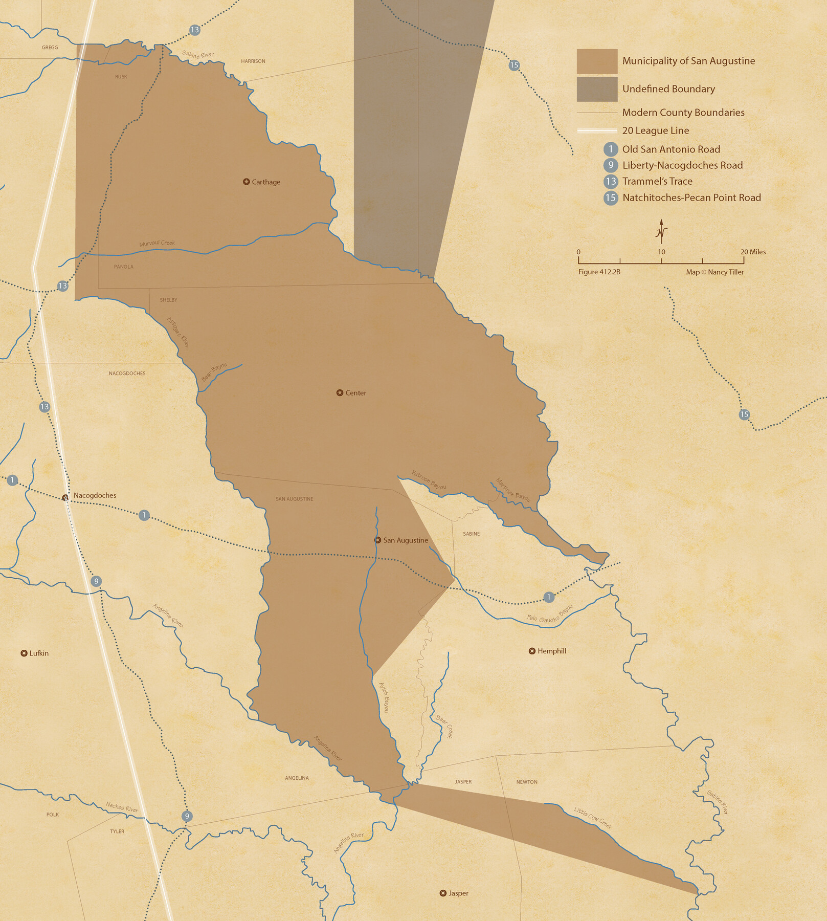
The Mexican Municipality of San Augustine. December 15, 1835
Figure No. 412.2 from 'A Boundary Atlas of Texas, 1821-1845' by Jim Tiller
-
Map/Doc
96033
-
Collection
Nancy and Jim Tiller Digital Collection
-
Object Dates
2020/1/1 (Creation Date)
-
People and Organizations
Jim Tiller (Author)
Nancy Tiller (Cartographer)
Gang Gong (GIS Professional)
-
Subjects
Atlas Mexican Texas Texas Boundaries
-
Height x Width
24.1 x 21.7 inches
61.2 x 55.1 cm
-
Medium
digital image
-
Comments
To purchase a digital PDF copy of "A Boundary Atlas of Texas, 1821-1845" see 96437.
Part of: Nancy and Jim Tiller Digital Collection
The Republic County of Fannin. December 29, 1845

Print $20.00
The Republic County of Fannin. December 29, 1845
2020
Size 12.9 x 21.7 inches
Map/Doc 96130
The Republic County of Bowie. June 24, 1841

Print $20.00
The Republic County of Bowie. June 24, 1841
2020
Size 19.5 x 21.7 inches
Map/Doc 96104
The Republic County of Brazoria. December 29, 1845

Print $20.00
The Republic County of Brazoria. December 29, 1845
2020
Size 14.7 x 21.8 inches
Map/Doc 96115
Republic Counties. January 1, 1841

Print $20.00
Republic Counties. January 1, 1841
2020
Size 24.5 x 21.7 inches
Map/Doc 96314
The Republic County of Colorado. Proposed, Late Fall 1837-January 1, 1838

Print $20.00
The Republic County of Colorado. Proposed, Late Fall 1837-January 1, 1838
2020
Size 18.4 x 21.7 inches
Map/Doc 96119
From Citizens of Brazoria County to Annex the Island of San Luis, December 12, 1839

Print $20.00
From Citizens of Brazoria County to Annex the Island of San Luis, December 12, 1839
2020
Size 13.8 x 21.7 inches
Map/Doc 96387
The Republic County of Nacogdoches. November 28. 1839

Print $20.00
The Republic County of Nacogdoches. November 28. 1839
2020
Size 17.5 x 21.7 inches
Map/Doc 96245
The Mexican Department of Brazos. On the Eve of Texas Independence, 1836

Print $20.00
The Mexican Department of Brazos. On the Eve of Texas Independence, 1836
2020
Size 19.7 x 21.7 inches
Map/Doc 95976
The Republic County of Brazoria. December 16, 1839

Print $20.00
The Republic County of Brazoria. December 16, 1839
2020
Size 14.7 x 21.8 inches
Map/Doc 96113
The Republic County of Fayette. May 24, 1838

Print $20.00
The Republic County of Fayette. May 24, 1838
2020
Size 14.7 x 21.7 inches
Map/Doc 96133
The Republic County of Houston. February 2, 1842

Print $20.00
The Republic County of Houston. February 2, 1842
2020
Size 19.7 x 21.8 inches
Map/Doc 96181
The Mexican Department of Nacogdoches. Created, January 31, 1831

Print $20.00
The Mexican Department of Nacogdoches. Created, January 31, 1831
2020
Size 18.4 x 21.7 inches
Map/Doc 95972
You may also like
Coryell County Working Sketch 12

Print $20.00
- Digital $50.00
Coryell County Working Sketch 12
1949
Size 36.0 x 38.7 inches
Map/Doc 68219
Tarrant County Working Sketch 19

Print $20.00
- Digital $50.00
Tarrant County Working Sketch 19
1999
Size 11.8 x 18.1 inches
Map/Doc 62436
Baylor County Rolled Sketch 5

Print $20.00
- Digital $50.00
Baylor County Rolled Sketch 5
1874
Size 43.2 x 39.7 inches
Map/Doc 8444
Kimble County Rolled Sketch 38

Print $20.00
- Digital $50.00
Kimble County Rolled Sketch 38
1986
Size 28.3 x 21.7 inches
Map/Doc 6528
Comanche County Sketch File 16a

Print $4.00
- Digital $50.00
Comanche County Sketch File 16a
Size 6.1 x 8.5 inches
Map/Doc 19084
South Part Presidio County

Print $20.00
- Digital $50.00
South Part Presidio County
1975
Size 34.0 x 39.3 inches
Map/Doc 73266
Refugio County Boundary File 3

Print $4.00
- Digital $50.00
Refugio County Boundary File 3
Size 14.0 x 8.7 inches
Map/Doc 58244
[West Part of Claude E. Halsell's Survey Section 6 Block A7]
![91063, [West Part of Claude E. Halsell's Survey Section 6 Block A7], Twichell Survey Records](https://historictexasmaps.com/wmedia_w700/maps/91063-1.tif.jpg)
Print $2.00
- Digital $50.00
[West Part of Claude E. Halsell's Survey Section 6 Block A7]
Size 9.2 x 14.7 inches
Map/Doc 91063
Right-of-Way and Track Map, Texas State Railroad operated by the T. and N. O. R.R. Co.

Print $40.00
- Digital $50.00
Right-of-Way and Track Map, Texas State Railroad operated by the T. and N. O. R.R. Co.
1917
Size 24.5 x 55.9 inches
Map/Doc 64177
Oldham County Surveyor's Oath of Office

Print $3.00
Oldham County Surveyor's Oath of Office
1881
Size 15.2 x 9.7 inches
Map/Doc 47716
Jefferson County Rolled Sketch 61C

Print $20.00
- Digital $50.00
Jefferson County Rolled Sketch 61C
1928
Size 27.2 x 40.3 inches
Map/Doc 6412
Harrison County Rolled Sketch 11

Print $20.00
- Digital $50.00
Harrison County Rolled Sketch 11
1957
Size 24.7 x 30.2 inches
Map/Doc 6154