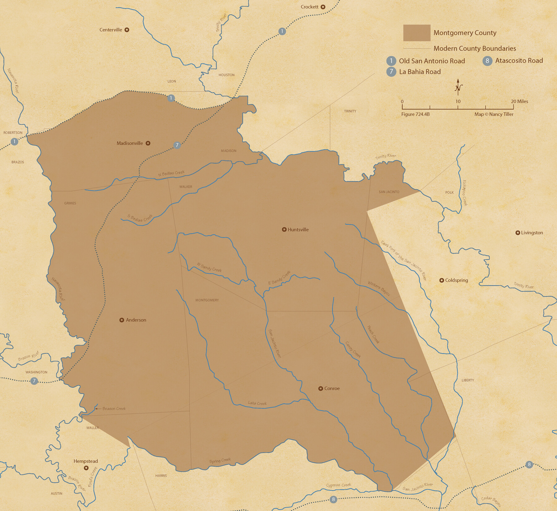
The Republic County of Montgomery. January 25, 1840
Figure No. 724.4 from 'A Boundary Atlas of Texas, 1821-1845' by Jim Tiller
-
Map/Doc
96237
-
Collection
Nancy and Jim Tiller Digital Collection
-
Object Dates
2020/1/1 (Creation Date)
-
People and Organizations
Jim Tiller (Author)
Nancy Tiller (Cartographer)
Gang Gong (GIS Professional)
-
Counties
Montgomery
-
Subjects
Atlas County Republic of Texas Texas Boundaries
-
Height x Width
19.9 x 21.7 inches
50.6 x 55.1 cm
-
Medium
digital image
-
Comments
To purchase a digital PDF copy of "A Boundary Atlas of Texas, 1821-1845" see 96437.
Part of: Nancy and Jim Tiller Digital Collection
Austin Empresario Colony. March 27, 1827

Print $20.00
Austin Empresario Colony. March 27, 1827
2020
Size 18.0 x 21.6 inches
Map/Doc 95980
de Leon Empresario Colony. April 15, 1824

Print $20.00
de Leon Empresario Colony. April 15, 1824
2020
Size 18.5 x 21.7 inches
Map/Doc 95988
The Land Offices. No. 10, Bexar, December 22, 1836

Print $20.00
The Land Offices. No. 10, Bexar, December 22, 1836
2020
Size 19.2 x 16.2 inches
Map/Doc 96423
The Land Offices. No. 2, San Augustine, December 22, 1836

Print $20.00
The Land Offices. No. 2, San Augustine, December 22, 1836
2020
Size 19.7 x 18.4 inches
Map/Doc 96415
The Republic County of Colorado. January 19, 1841

Print $20.00
The Republic County of Colorado. January 19, 1841
2020
Size 18.4 x 21.7 inches
Map/Doc 96124
The Judicial District/County of Guadalupe. Created, January 29, 1842

Print $20.00
The Judicial District/County of Guadalupe. Created, January 29, 1842
2020
Size 16.7 x 21.7 inches
Map/Doc 96327
DeWitt Empresario Colony. April 15, 1825

Print $20.00
DeWitt Empresario Colony. April 15, 1825
2020
Size 18.1 x 21.7 inches
Map/Doc 95991
The Republic County of Gonzales. December 18, 1837

Print $20.00
The Republic County of Gonzales. December 18, 1837
2020
Size 14.7 x 21.7 inches
Map/Doc 96154
The Republic County of Jefferson. Boundaries Defined, December 21, 1837

Print $20.00
The Republic County of Jefferson. Boundaries Defined, December 21, 1837
2020
Size 22.6 x 21.7 inches
Map/Doc 96197
Grant and Beales Empresario Colony. October 9, 1832

Print $20.00
Grant and Beales Empresario Colony. October 9, 1832
2020
Size 23.5 x 21.7 inches
Map/Doc 95996
The Judicial District/County of Menard. Abolished, Spring 1842

Print $20.00
The Judicial District/County of Menard. Abolished, Spring 1842
2020
Size 22.4 x 21.7 inches
Map/Doc 96337
Austin Empresario Colony. July 9, 1828

Print $20.00
Austin Empresario Colony. July 9, 1828
2020
Size 16.4 x 21.7 inches
Map/Doc 95982
You may also like
Blanco County Working Sketch 11

Print $3.00
- Digital $50.00
Blanco County Working Sketch 11
1941
Size 10.8 x 10.4 inches
Map/Doc 67371
Burleson County Working Sketch 23

Print $20.00
- Digital $50.00
Burleson County Working Sketch 23
1980
Size 17.9 x 16.6 inches
Map/Doc 67742
Houston & Texas Central Railway Through Bastrop County

Print $40.00
- Digital $50.00
Houston & Texas Central Railway Through Bastrop County
1916
Size 21.3 x 116.5 inches
Map/Doc 64418
Crockett County Rolled Sketch 41

Print $20.00
- Digital $50.00
Crockett County Rolled Sketch 41
Size 24.7 x 19.6 inches
Map/Doc 5591
Map of the United States, Canada and a part of Mexico to illustrate Olney's school geography

Print $20.00
- Digital $50.00
Map of the United States, Canada and a part of Mexico to illustrate Olney's school geography
1844
Size 12.1 x 19.0 inches
Map/Doc 93537
Swisher County Boundary File 2

Print $106.00
- Digital $50.00
Swisher County Boundary File 2
Size 14.3 x 9.0 inches
Map/Doc 59093
Leon County Rolled Sketch 31A

Print $20.00
- Digital $50.00
Leon County Rolled Sketch 31A
1995
Size 38.9 x 15.4 inches
Map/Doc 6615
South Part of Webb County

Print $40.00
- Digital $50.00
South Part of Webb County
1984
Size 43.5 x 63.9 inches
Map/Doc 73320
Reeves County Working Sketch 59

Print $40.00
- Digital $50.00
Reeves County Working Sketch 59
1981
Size 36.3 x 72.8 inches
Map/Doc 63502
Rusk County Sketch File 31

Print $10.00
Rusk County Sketch File 31
1949
Size 11.3 x 8.9 inches
Map/Doc 35563
General Highway Map, Montgomery County, Texas

Print $20.00
General Highway Map, Montgomery County, Texas
1939
Size 18.4 x 24.6 inches
Map/Doc 79202
Crockett County Sketch File 60

Print $22.00
- Digital $50.00
Crockett County Sketch File 60
1925
Size 11.4 x 8.7 inches
Map/Doc 19837