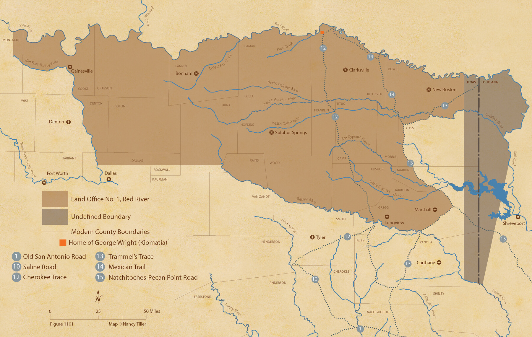
The Land Offices. No. 1, Red River, December 22, 1836
Figure No. 1101 from 'A Boundary Atlas of Texas, 1821-1845' by Jim Tiller
-
Map/Doc
96414
-
Collection
Nancy and Jim Tiller Digital Collection
-
Object Dates
2020/1/1 (Creation Date)
-
People and Organizations
Jim Tiller (Author)
Nancy Tiller (Cartographer)
Gang Gong (GIS Professional)
-
Subjects
Atlas Republic of Texas Texas Boundaries
-
Height x Width
13.7 x 21.7 inches
34.8 x 55.1 cm
-
Medium
digital image
-
Comments
To purchase a digital PDF copy of "A Boundary Atlas of Texas, 1821-1845" see 96437.
Part of: Nancy and Jim Tiller Digital Collection
Power and Hewetson Empresario Colony. April 2, 1829

Print $20.00
Power and Hewetson Empresario Colony. April 2, 1829
2020
Size 17.5 x 21.6 inches
Map/Doc 96004
The Republic County of San Augustine. December 29, 1845

Print $20.00
The Republic County of San Augustine. December 29, 1845
2020
Size 18.8 x 21.7 inches
Map/Doc 96272
The Peters Colony. January 29, 1844

Print $20.00
The Peters Colony. January 29, 1844
2020
Size 17.2 x 21.7 inches
Map/Doc 96366
The Republic County of Gonzales. May 3, 1838

Print $20.00
The Republic County of Gonzales. May 3, 1838
2020
Size 14.7 x 21.7 inches
Map/Doc 96155
The Republic County of Jefferson. Boundaries Defined, December 21, 1837

Print $20.00
The Republic County of Jefferson. Boundaries Defined, December 21, 1837
2020
Size 22.6 x 21.7 inches
Map/Doc 96197
Dominguez Empresario Colony. February 6, 1829

Print $20.00
Dominguez Empresario Colony. February 6, 1829
2020
Size 17.2 x 21.7 inches
Map/Doc 95992
The Judicial District/County of DeWitt. Created, February 2, 1842

Print $20.00
The Judicial District/County of DeWitt. Created, February 2, 1842
2020
Size 22.4 x 21.7 inches
Map/Doc 96325
From Citizens of Montgomery County for the Creation of a New County to be Called Bowie, January 18, 1838

Print $20.00
From Citizens of Montgomery County for the Creation of a New County to be Called Bowie, January 18, 1838
2020
Size 19.1 x 21.7 inches
Map/Doc 96376
The Republic County of Montgomery. January 25, 1840

Print $20.00
The Republic County of Montgomery. January 25, 1840
2020
Size 19.9 x 21.7 inches
Map/Doc 96237
The Republic County of Jefferson. January 20, 1841

Print $20.00
The Republic County of Jefferson. January 20, 1841
2020
Size 22.6 x 21.7 inches
Map/Doc 96198
The Republic County of Milam. December 31, 1838

Print $20.00
The Republic County of Milam. December 31, 1838
2020
Size 17.4 x 21.6 inches
Map/Doc 96227
The Republic County of Fayette. May 24, 1838

Print $20.00
The Republic County of Fayette. May 24, 1838
2020
Size 14.7 x 21.7 inches
Map/Doc 96133
You may also like
Goliad County Working Sketch 10

Print $20.00
- Digital $50.00
Goliad County Working Sketch 10
1939
Size 39.9 x 42.4 inches
Map/Doc 63200
Coryell County Sketch File 16

Print $4.00
- Digital $50.00
Coryell County Sketch File 16
Size 6.5 x 5.4 inches
Map/Doc 19373
Flight Mission No. BRA-3M, Frame 118, Jefferson County

Print $20.00
- Digital $50.00
Flight Mission No. BRA-3M, Frame 118, Jefferson County
1953
Size 18.6 x 22.3 inches
Map/Doc 85392
Brewster County Sketch File N-16

Print $16.00
- Digital $50.00
Brewster County Sketch File N-16
1922
Size 6.2 x 8.7 inches
Map/Doc 15643
Marion County Working Sketch 18

Print $20.00
- Digital $50.00
Marion County Working Sketch 18
1957
Size 36.4 x 40.3 inches
Map/Doc 70794
Val Verde County Working Sketch 29

Print $20.00
- Digital $50.00
Val Verde County Working Sketch 29
1937
Size 20.2 x 41.6 inches
Map/Doc 72164
El Paso County Boundary File 6

Print $14.00
- Digital $50.00
El Paso County Boundary File 6
Size 14.0 x 8.8 inches
Map/Doc 53080
Map of Velasco

Print $20.00
- Digital $50.00
Map of Velasco
1906
Size 32.1 x 39.4 inches
Map/Doc 95357
Map of City of Fort Worth, Texas

Print $20.00
- Digital $50.00
Map of City of Fort Worth, Texas
1934
Size 32.9 x 39.2 inches
Map/Doc 4839
Freestone County Working Sketch 3

Print $20.00
- Digital $50.00
Freestone County Working Sketch 3
1914
Size 18.8 x 16.2 inches
Map/Doc 69245
Val Verde County Sketch File XXX6

Print $6.00
- Digital $50.00
Val Verde County Sketch File XXX6
Size 17.0 x 9.9 inches
Map/Doc 39102
[Old Coastal Chart of Texas Coast showing passes with depth readings]
![4662, [Old Coastal Chart of Texas Coast showing passes with depth readings], General Map Collection](https://historictexasmaps.com/wmedia_w700/maps/4662-1.tif.jpg)
Print $40.00
- Digital $50.00
[Old Coastal Chart of Texas Coast showing passes with depth readings]
Size 25.4 x 48.6 inches
Map/Doc 4662