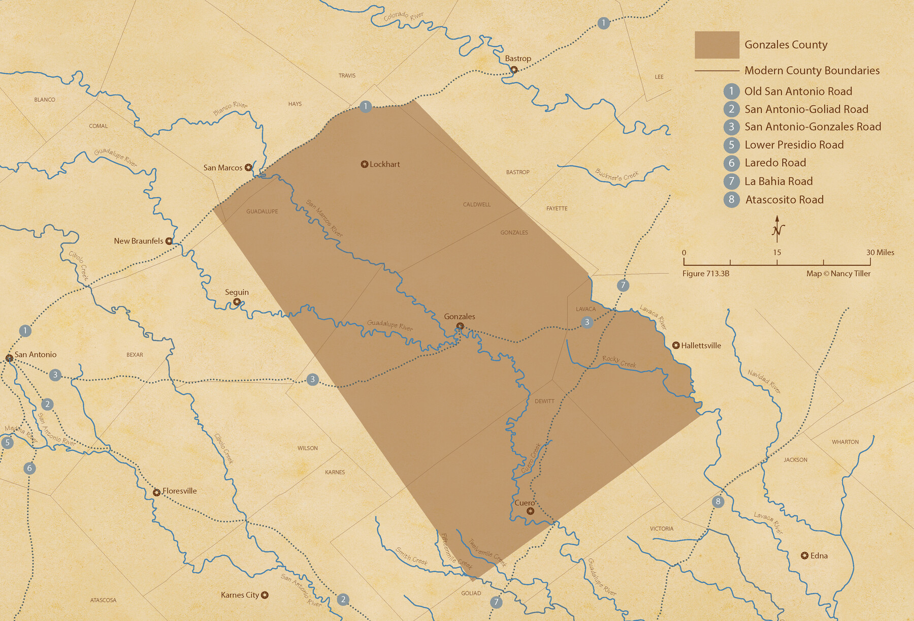
The Republic County of Gonzales. May 3, 1838
Figure No. 713.3 from 'A Boundary Atlas of Texas, 1821-1845' by Jim Tiller
-
Map/Doc
96155
-
Collection
Nancy and Jim Tiller Digital Collection
-
Object Dates
2020/1/1 (Creation Date)
-
People and Organizations
Jim Tiller (Author)
Nancy Tiller (Cartographer)
Gang Gong (GIS Professional)
-
Counties
Gonzales
-
Subjects
Atlas County Republic of Texas Texas Boundaries
-
Height x Width
14.7 x 21.7 inches
37.3 x 55.1 cm
-
Medium
digital image
-
Comments
To purchase a digital PDF copy of "A Boundary Atlas of Texas, 1821-1845" see 96437.
Part of: Nancy and Jim Tiller Digital Collection
The Chief Justice County of Milam. April 16, 1837

Print $20.00
The Chief Justice County of Milam. April 16, 1837
2020
Size 16.8 x 21.7 inches
Map/Doc 96059
The Republic County of Robertson. January 29, 1842

Print $20.00
The Republic County of Robertson. January 29, 1842
2020
Size 16.9 x 21.7 inches
Map/Doc 96262
The Republic County of Fayette. January 29, 1842

Print $20.00
The Republic County of Fayette. January 29, 1842
2020
Size 14.7 x 21.7 inches
Map/Doc 96134
The Republic County of Colorado. December 29, 1845

Print $20.00
The Republic County of Colorado. December 29, 1845
2020
Size 18.4 x 21.7 inches
Map/Doc 96127
The Judicial District/County of Lavaca. Abolished, Spring 1842

Print $20.00
The Judicial District/County of Lavaca. Abolished, Spring 1842
2020
Size 14.6 x 21.7 inches
Map/Doc 96332
The Judicial District/County of Guadalupe. Created, January 29, 1842

Print $20.00
The Judicial District/County of Guadalupe. Created, January 29, 1842
2020
Size 16.7 x 21.7 inches
Map/Doc 96327
The Republic County of Montgomery. December 29, 1845

Print $20.00
The Republic County of Montgomery. December 29, 1845
2020
Size 19.9 x 21.7 inches
Map/Doc 96241
The Republic County of Bowie. January 28, 1841

Print $20.00
The Republic County of Bowie. January 28, 1841
2020
Size 19.5 x 21.7 inches
Map/Doc 96103
The Republic County of Rusk. December 29, 1845

Print $20.00
The Republic County of Rusk. December 29, 1845
2020
Size 19.1 x 21.7 inches
Map/Doc 96268
Republic Counties. January 1, 1841

Print $20.00
Republic Counties. January 1, 1841
2020
Size 24.5 x 21.7 inches
Map/Doc 96314
The Judicial District/County of Menard. Created, January 22, 1841

Print $20.00
The Judicial District/County of Menard. Created, January 22, 1841
2020
Size 22.4 x 21.7 inches
Map/Doc 96335
The Republic County of Austin. January 10, 1839

Print $20.00
The Republic County of Austin. January 10, 1839
2020
Size 7.0 x 22.0 inches
Map/Doc 96083
You may also like
Tarrant County, Texas

Print $20.00
- Digital $50.00
Tarrant County, Texas
1870
Size 24.1 x 19.1 inches
Map/Doc 758
Working Sketch Carson County

Print $3.00
- Digital $50.00
Working Sketch Carson County
1907
Size 10.6 x 17.1 inches
Map/Doc 90223
Presidio County Rolled Sketch 7

Print $40.00
- Digital $50.00
Presidio County Rolled Sketch 7
1875
Size 37.5 x 53.8 inches
Map/Doc 9762
Flight Mission No. BRA-16M, Frame 50, Jefferson County

Print $20.00
- Digital $50.00
Flight Mission No. BRA-16M, Frame 50, Jefferson County
1953
Size 18.5 x 22.5 inches
Map/Doc 85667
Flight Mission No. BQY-4M, Frame 125, Harris County

Print $20.00
- Digital $50.00
Flight Mission No. BQY-4M, Frame 125, Harris County
1953
Size 18.6 x 22.5 inches
Map/Doc 85293
H No. 3 - Reconnoissance of the Passes of the Delta of the Mississippi, Louisiana showing the changes since 1839

Print $20.00
- Digital $50.00
H No. 3 - Reconnoissance of the Passes of the Delta of the Mississippi, Louisiana showing the changes since 1839
1852
Size 15.9 x 22.8 inches
Map/Doc 97224
Military Reconnaissance [showing forts along Rio Grande near Matamoros]
![72910, Military Reconnaissance [showing forts along Rio Grande near Matamoros], General Map Collection](https://historictexasmaps.com/wmedia_w700/maps/72910.tif.jpg)
Print $20.00
- Digital $50.00
Military Reconnaissance [showing forts along Rio Grande near Matamoros]
1846
Size 18.4 x 26.7 inches
Map/Doc 72910
San Patricio County Rolled Sketch 7A

Print $20.00
- Digital $50.00
San Patricio County Rolled Sketch 7A
1870
Size 46.8 x 27.3 inches
Map/Doc 9884
Flight Mission No. DAG-21K, Frame 37, Matagorda County

Print $20.00
- Digital $50.00
Flight Mission No. DAG-21K, Frame 37, Matagorda County
1952
Size 18.5 x 22.4 inches
Map/Doc 86404
San Patricio County Sketch File 50

Print $8.00
- Digital $50.00
San Patricio County Sketch File 50
1873
Size 14.4 x 8.8 inches
Map/Doc 36371
Matagorda County Sketch File 8

Print $4.00
- Digital $50.00
Matagorda County Sketch File 8
1877
Size 12.9 x 8.0 inches
Map/Doc 30750
Eastland County Working Sketch 6

Print $20.00
- Digital $50.00
Eastland County Working Sketch 6
1918
Size 17.2 x 11.4 inches
Map/Doc 68787