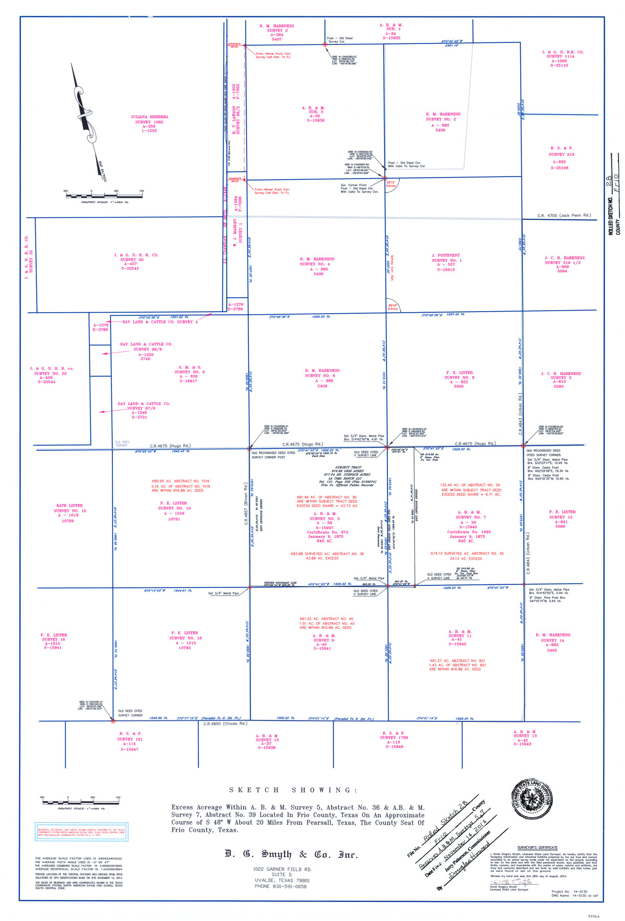
Frio County Rolled Sketch 28
Sketch showing excess acreage within A. B. & M. Survey 5. Abstract No. 36 & A. B. & M. Survey 7, Abstract No. 39
-
Map/Doc
97420
-
Collection
General Map Collection
-
Object Dates
8/28/2014 (Creation Date)
11/14/2014 (File Date)
-
People and Organizations
David Gregory Smyth (Surveyor/Engineer)
-
Counties
Frio
-
Subjects
Surveying Rolled Sketch
-
Height x Width
36.3 x 24.7 inches
92.2 x 62.7 cm
-
Scale
1" = 360 varas
Part of: General Map Collection
Stonewall County Boundary File 1

Print $34.00
- Digital $50.00
Stonewall County Boundary File 1
Size 9.0 x 8.4 inches
Map/Doc 58938
Denton County Working Sketch 26

Print $20.00
- Digital $50.00
Denton County Working Sketch 26
1995
Size 29.3 x 33.9 inches
Map/Doc 68631


Lavaca County Rolled Sketch 6

Print $20.00
- Digital $50.00
Lavaca County Rolled Sketch 6
1986
Size 44.8 x 33.9 inches
Map/Doc 10290
Zavala County Rolled Sketch 28

Print $20.00
- Digital $50.00
Zavala County Rolled Sketch 28
1956
Size 29.6 x 41.2 inches
Map/Doc 8330
Parker County Sketch File 32

Print $6.00
- Digital $50.00
Parker County Sketch File 32
Size 11.0 x 12.2 inches
Map/Doc 33574
Sketch of a road from Fort Croghan to Phantom Hill, Texas

Print $20.00
- Digital $50.00
Sketch of a road from Fort Croghan to Phantom Hill, Texas
1852
Size 34.7 x 12.2 inches
Map/Doc 2007
Galveston County Rolled Sketch 30

Print $20.00
- Digital $50.00
Galveston County Rolled Sketch 30
1979
Size 28.0 x 39.8 inches
Map/Doc 5964
Brewster County Sketch File NS-4b

Print $40.00
- Digital $50.00
Brewster County Sketch File NS-4b
Size 30.4 x 35.8 inches
Map/Doc 10988
Hood County Working Sketch 18

Print $40.00
- Digital $50.00
Hood County Working Sketch 18
1987
Size 38.8 x 59.0 inches
Map/Doc 66212
Flight Mission No. DIX-5P, Frame 139, Aransas County

Print $20.00
- Digital $50.00
Flight Mission No. DIX-5P, Frame 139, Aransas County
1956
Size 17.6 x 17.8 inches
Map/Doc 83800
You may also like
Flight Mission No. CLL-3N, Frame 36, Willacy County

Print $20.00
- Digital $50.00
Flight Mission No. CLL-3N, Frame 36, Willacy County
1954
Size 18.4 x 22.2 inches
Map/Doc 87094
Bee County Working Sketch 31a

Print $20.00
- Digital $50.00
Bee County Working Sketch 31a
1988
Size 39.5 x 43.2 inches
Map/Doc 76052
East Part of Jeff Davis Co.

Print $20.00
- Digital $50.00
East Part of Jeff Davis Co.
1977
Size 46.4 x 35.7 inches
Map/Doc 73194

Cameron County

Print $20.00
- Digital $50.00
Cameron County
1976
Size 32.2 x 39.0 inches
Map/Doc 73098
Crockett County Working Sketch 46

Print $20.00
- Digital $50.00
Crockett County Working Sketch 46
1935
Size 32.9 x 27.4 inches
Map/Doc 68379
Hays County Rolled Sketch 26

Print $20.00
- Digital $50.00
Hays County Rolled Sketch 26
1943
Size 27.7 x 25.6 inches
Map/Doc 6182
A Map of the Republic of Texas and the adjacent territories, indicating the grants of land conceded under the empresario system of Mexico

Print $20.00
- Digital $50.00
A Map of the Republic of Texas and the adjacent territories, indicating the grants of land conceded under the empresario system of Mexico
1841
Size 13.8 x 16.6 inches
Map/Doc 93752
Harris County Working Sketch 42

Print $20.00
- Digital $50.00
Harris County Working Sketch 42
1940
Size 31.8 x 38.5 inches
Map/Doc 65934
Flight Mission No. BRA-7M, Frame 181, Jefferson County

Print $20.00
- Digital $50.00
Flight Mission No. BRA-7M, Frame 181, Jefferson County
1953
Size 18.6 x 22.4 inches
Map/Doc 85549
Current Miscellaneous File 92

Print $22.00
- Digital $50.00
Current Miscellaneous File 92
1990
Size 11.2 x 8.8 inches
Map/Doc 74265
Donley County Sketch File 3

Print $6.00
- Digital $50.00
Donley County Sketch File 3
Size 10.8 x 11.9 inches
Map/Doc 21217