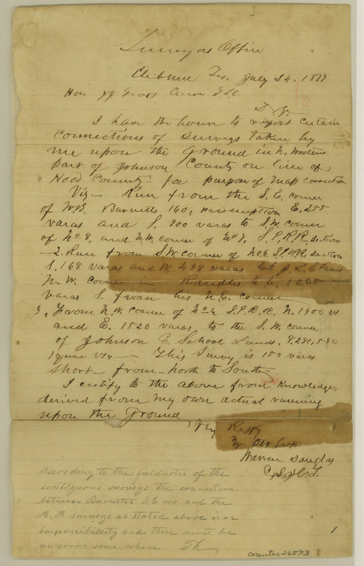
Hood County Sketch File 3
[Connecting line from southeast corner of W. B. Burnett to southwest corner of Johnson County School Land]
-
Map/Doc
26573
-
Collection
General Map Collection
-
Object Dates
7/24/1877 (Creation Date)
1/9/1878 (File Date)
7/24/1877 (Correspondence Date)
-
People and Organizations
Warren Douglas (Surveyor/Engineer)
-
Counties
Hood Johnson
-
Subjects
Surveying Sketch File
-
Height x Width
12.7 x 8.1 inches
32.3 x 20.6 cm
-
Medium
paper, manuscript
Part of: General Map Collection
State Prison Lands Transferred to A&M College, Forest Division, Cherokee County

Print $4.00
- Digital $50.00
State Prison Lands Transferred to A&M College, Forest Division, Cherokee County
1932
Size 11.1 x 20.1 inches
Map/Doc 65086
Menard County Working Sketch 30

Print $20.00
- Digital $50.00
Menard County Working Sketch 30
1974
Size 47.9 x 38.8 inches
Map/Doc 70977
Nueces County Rolled Sketch 127

Print $20.00
- Digital $50.00
Nueces County Rolled Sketch 127
1998
Size 24.1 x 36.4 inches
Map/Doc 7162
Comal County Sketch File 12

Print $4.00
- Digital $50.00
Comal County Sketch File 12
Size 8.4 x 11.3 inches
Map/Doc 19024
Austin County Working Sketch 5

Print $20.00
- Digital $50.00
Austin County Working Sketch 5
1965
Size 23.4 x 27.8 inches
Map/Doc 67246
Martin County

Print $20.00
- Digital $50.00
Martin County
1933
Size 43.8 x 38.9 inches
Map/Doc 73230
Dickens County Rolled Sketch 1/2
Print $20.00
- Digital $50.00
Dickens County Rolled Sketch 1/2
1903
Size 23.3 x 22.6 inches
Map/Doc 5705
Reeves County Sketch File 28

Print $12.00
- Digital $50.00
Reeves County Sketch File 28
2003
Size 14.3 x 8.8 inches
Map/Doc 78496

Brewster County Sketch File 24

Print $40.00
- Digital $50.00
Brewster County Sketch File 24
1957
Size 14.3 x 15.5 inches
Map/Doc 15831
Hood County Working Sketch 9

Print $20.00
- Digital $50.00
Hood County Working Sketch 9
1972
Size 28.0 x 31.7 inches
Map/Doc 66203
United States Bathymetric and Fishing Maps including Topographic/Bathymetric Maps

Print $40.00
- Digital $50.00
United States Bathymetric and Fishing Maps including Topographic/Bathymetric Maps
1989
Size 20.4 x 54.4 inches
Map/Doc 73557
You may also like
Pecos County Sketch File 118

Print $28.00
- Digital $50.00
Pecos County Sketch File 118
1933
Size 5.0 x 7.5 inches
Map/Doc 34097
Flight Mission No. CUG-1P, Frame 74, Kleberg County

Print $20.00
- Digital $50.00
Flight Mission No. CUG-1P, Frame 74, Kleberg County
1956
Size 18.5 x 22.3 inches
Map/Doc 86139
Galveston to Rio Grande

Print $20.00
- Digital $50.00
Galveston to Rio Grande
1941
Size 43.7 x 37.1 inches
Map/Doc 69957
Coke County Working Sketch 14

Print $40.00
- Digital $50.00
Coke County Working Sketch 14
1948
Size 50.3 x 43.1 inches
Map/Doc 68051
El Paso County Rolled Sketch 38
Print $40.00
- Digital $50.00
El Paso County Rolled Sketch 38
1922
Size 14.1 x 61.3 inches
Map/Doc 8866
Irion County Rolled Sketch 18B

Print $152.00
- Digital $50.00
Irion County Rolled Sketch 18B
1978
Size 10.6 x 15.2 inches
Map/Doc 46087


Brazoria County Aerial Photograph Index Sheet 7

Print $20.00
- Digital $50.00
Brazoria County Aerial Photograph Index Sheet 7
1953
Size 23.9 x 19.8 inches
Map/Doc 83669
Wharton County Working Sketch 10

Print $20.00
- Digital $50.00
Wharton County Working Sketch 10
1980
Size 23.6 x 18.7 inches
Map/Doc 72474
Flight Mission No. CUG-2P, Frame 61, Kleberg County

Print $20.00
- Digital $50.00
Flight Mission No. CUG-2P, Frame 61, Kleberg County
1956
Size 18.5 x 22.2 inches
Map/Doc 86198
Fort Bend County Working Sketch 21

Print $20.00
- Digital $50.00
Fort Bend County Working Sketch 21
Size 26.9 x 28.6 inches
Map/Doc 69227