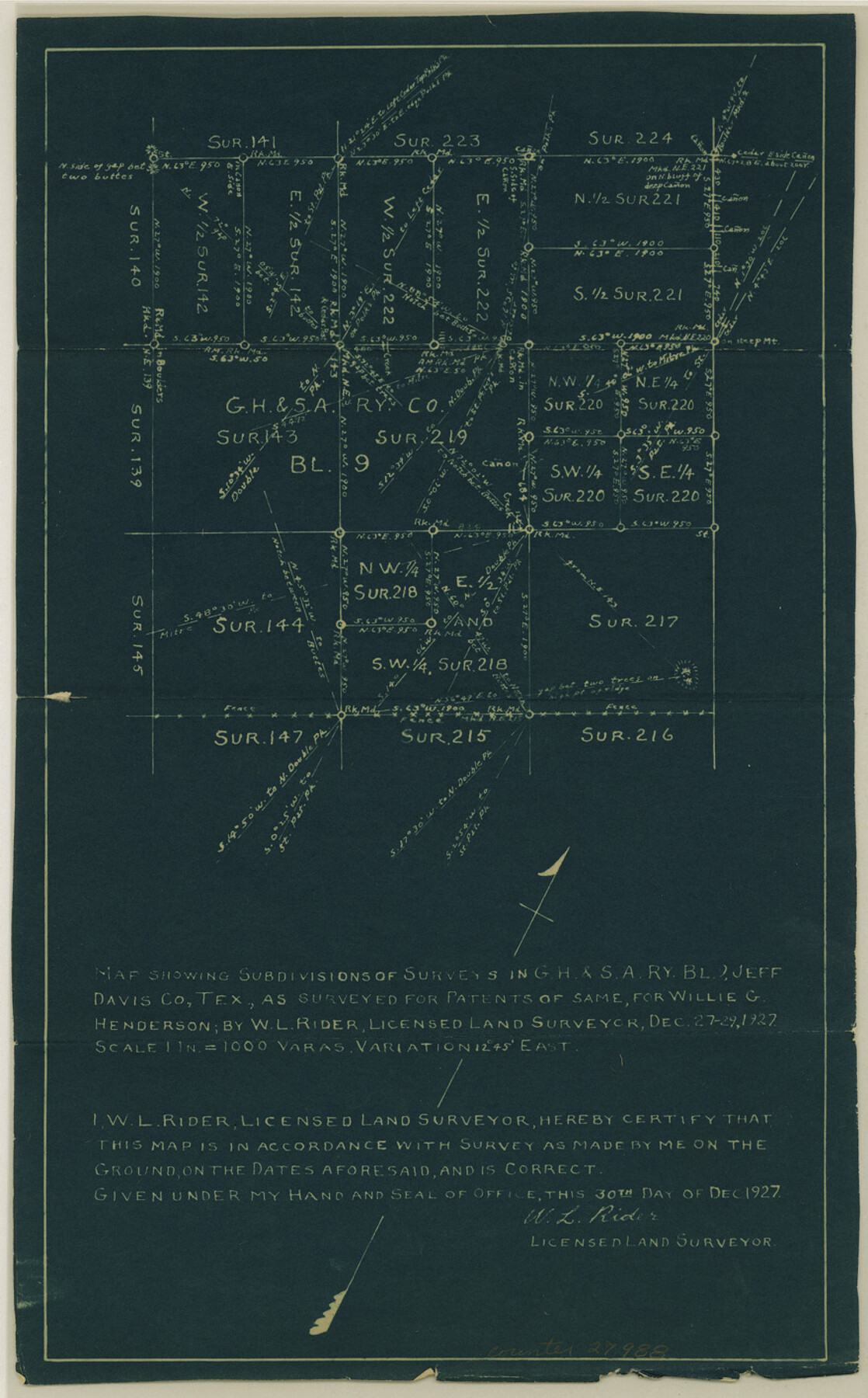
Jeff Davis County Sketch File 21
[Sketch of Block 9]
-
Map/Doc
27988
-
Collection
General Map Collection
-
Object Dates
12/30/1927 (Creation Date)
1/16/1928 (File Date)
12/29/1927 (Survey Date)
-
People and Organizations
W.L. Rider (Surveyor/Engineer)
-
Counties
Jeff Davis
-
Subjects
Surveying Sketch File
-
Height x Width
14.1 x 8.8 inches
35.8 x 22.4 cm
-
Medium
blueprint/diazo
-
Scale
1" = 1000 varas
Part of: General Map Collection
Hutchinson County Sketch File 26

Print $20.00
- Digital $50.00
Hutchinson County Sketch File 26
1920
Size 18.6 x 17.4 inches
Map/Doc 11816

Flight Mission No. DAG-18K, Frame 68, Matagorda County

Print $20.00
- Digital $50.00
Flight Mission No. DAG-18K, Frame 68, Matagorda County
1952
Size 16.4 x 16.3 inches
Map/Doc 86361
El Paso County Working Sketch 8

Print $20.00
- Digital $50.00
El Paso County Working Sketch 8
1952
Size 23.9 x 22.5 inches
Map/Doc 69030
Medina County Sketch File 3

Print $4.00
- Digital $50.00
Medina County Sketch File 3
Size 8.1 x 7.3 inches
Map/Doc 31445
El Paso County Working Sketch 25

Print $20.00
- Digital $50.00
El Paso County Working Sketch 25
1962
Size 42.7 x 41.9 inches
Map/Doc 69047
Cherokee County Sketch File 10

Print $4.00
- Digital $50.00
Cherokee County Sketch File 10
1847
Size 8.2 x 9.5 inches
Map/Doc 18136
Roberts County Sketch File 2

Print $6.00
- Digital $50.00
Roberts County Sketch File 2
1882
Size 12.8 x 8.0 inches
Map/Doc 35303
East Part of West Bay and Southwest Part of Galveston Bay, Galveston County, showing Subdivision for Mineral Development

Print $40.00
- Digital $50.00
East Part of West Bay and Southwest Part of Galveston Bay, Galveston County, showing Subdivision for Mineral Development
1963
Size 42.2 x 58.2 inches
Map/Doc 1906
Montague County Boundary File 2d

Print $4.00
- Digital $50.00
Montague County Boundary File 2d
Size 12.5 x 8.2 inches
Map/Doc 57432
Nueces County Rolled Sketch 45

Print $20.00
- Digital $50.00
Nueces County Rolled Sketch 45
1941
Size 40.5 x 45.0 inches
Map/Doc 10295
Taylor County Sketch File 22

Print $189.00
- Digital $50.00
Taylor County Sketch File 22
1985
Size 14.6 x 8.9 inches
Map/Doc 37826
You may also like
Stonewall County Sketch File 25

Print $7.00
- Digital $50.00
Stonewall County Sketch File 25
1952
Size 26.7 x 43.3 inches
Map/Doc 10375
[Block A, Section 1, Block O, Sections 1 and 3]
![91390, [Block A, Section 1, Block O, Sections 1 and 3], Twichell Survey Records](https://historictexasmaps.com/wmedia_w700/maps/91390-1.tif.jpg)
Print $2.00
- Digital $50.00
[Block A, Section 1, Block O, Sections 1 and 3]
Size 8.5 x 8.4 inches
Map/Doc 91390
Sketch from old map (authority unknown) showing a portion of the Rio Grande River and harbor of Brazos Santiago, Texas

Print $20.00
- Digital $50.00
Sketch from old map (authority unknown) showing a portion of the Rio Grande River and harbor of Brazos Santiago, Texas
1887
Size 18.4 x 24.1 inches
Map/Doc 73004
Flight Mission No. BQR-22K, Frame 37, Brazoria County

Print $20.00
- Digital $50.00
Flight Mission No. BQR-22K, Frame 37, Brazoria County
1953
Size 18.8 x 22.4 inches
Map/Doc 84121
Goliad County Sketch File 3

Print $4.00
- Digital $50.00
Goliad County Sketch File 3
1852
Size 12.4 x 8.2 inches
Map/Doc 24214
Brazoria County Rolled Sketch 51

Print $20.00
- Digital $50.00
Brazoria County Rolled Sketch 51
2007
Size 34.8 x 46.8 inches
Map/Doc 87377
Harris County NRC Article 33.136 Sketch 12

Print $30.00
- Digital $50.00
Harris County NRC Article 33.136 Sketch 12
2007
Size 24.0 x 17.5 inches
Map/Doc 94627
Flight Mission No. DQN-6K, Frame 89, Calhoun County

Print $20.00
- Digital $50.00
Flight Mission No. DQN-6K, Frame 89, Calhoun County
1953
Size 18.5 x 22.2 inches
Map/Doc 84449
Flight Mission No. DAG-17K, Frame 62, Matagorda County

Print $20.00
- Digital $50.00
Flight Mission No. DAG-17K, Frame 62, Matagorda County
1952
Size 16.4 x 16.4 inches
Map/Doc 86324
Brewster County Working Sketch 49

Print $20.00
- Digital $50.00
Brewster County Working Sketch 49
1949
Size 37.1 x 22.6 inches
Map/Doc 67583
Map of the United States of America with its territories and districts including also a part of upper and lower Canada and Mexico

Print $20.00
Map of the United States of America with its territories and districts including also a part of upper and lower Canada and Mexico
1835
Size 30.3 x 43.2 inches
Map/Doc 79728
[Channing Vacancy, Leagues 217- 235 and Vicinity]
![91483, [Channing Vacancy, Leagues 217- 235 and Vicinity], Twichell Survey Records](https://historictexasmaps.com/wmedia_w700/maps/91483-1.tif.jpg)
Print $20.00
- Digital $50.00
[Channing Vacancy, Leagues 217- 235 and Vicinity]
Size 26.7 x 27.6 inches
Map/Doc 91483