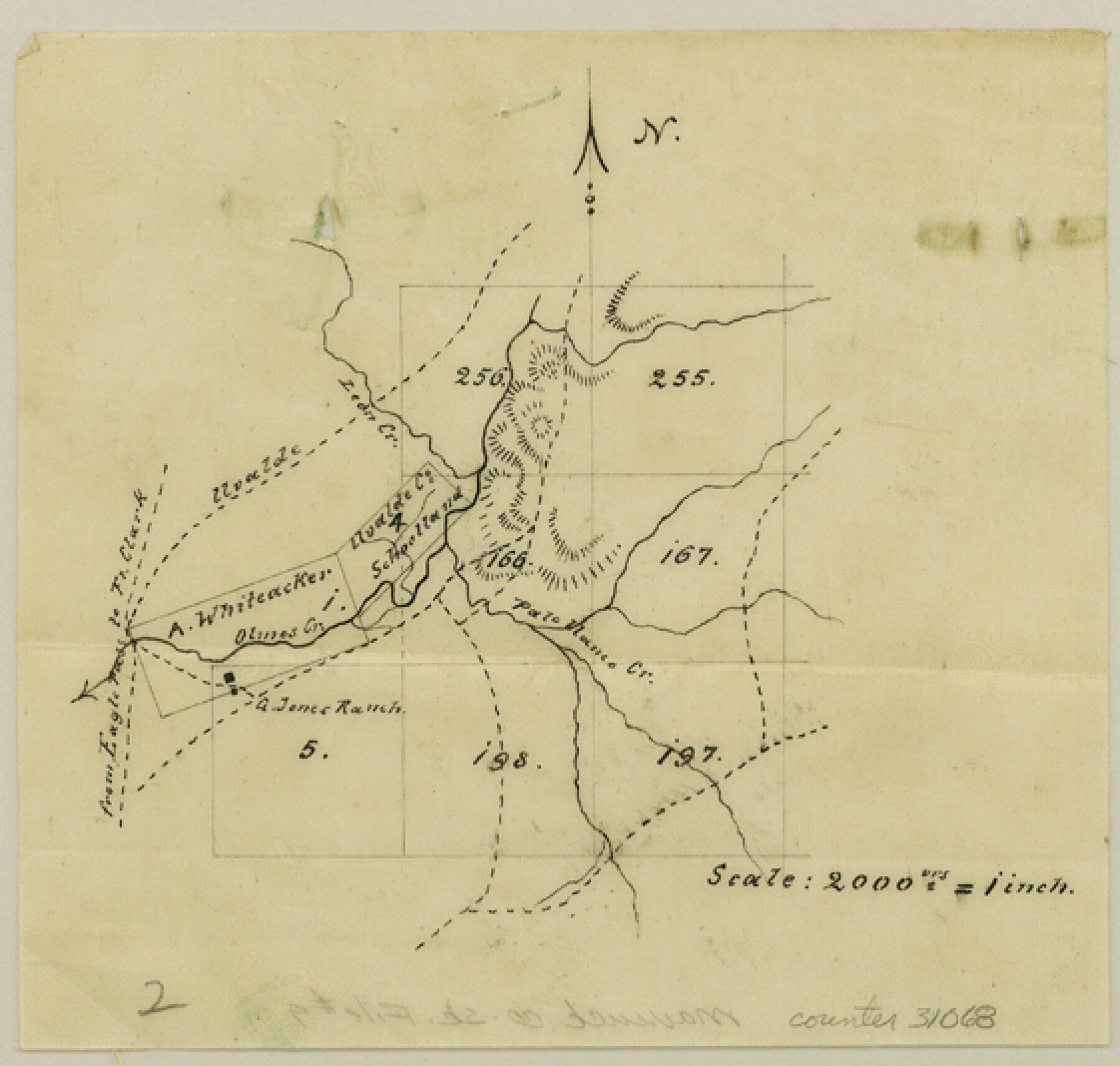
Maverick County Sketch File 9
[Sketch and field notes of connecting line northeast of Eagle Pass]
-
Map/Doc
31068
-
Collection
General Map Collection
-
Object Dates
3/1878 (Creation Date)
3/28/1878 (File Date)
-
People and Organizations
A. Wyschetzki (Surveyor/Engineer)
-
Counties
Maverick
-
Subjects
Surveying Sketch File
-
Height x Width
5.3 x 5.6 inches
13.5 x 14.2 cm
-
Medium
paper, manuscript
-
Scale
1" = 2000 varas
-
Features
Saus Creek
Leon Creek
Palo Blanco Creek
[Stage Road] from Eagle Pass to Fort Clark
A. James Ranch
Olmos Creek
Part of: General Map Collection
Tom Green County Rolled Sketch 20

Print $20.00
- Digital $50.00
Tom Green County Rolled Sketch 20
Size 20.7 x 13.3 inches
Map/Doc 8003
El Paso County Rolled Sketch 49

Print $40.00
- Digital $50.00
El Paso County Rolled Sketch 49
Size 10.5 x 99.9 inches
Map/Doc 8875
Cottle County Working Sketch 16

Print $20.00
- Digital $50.00
Cottle County Working Sketch 16
1975
Size 24.5 x 21.6 inches
Map/Doc 68326
Flight Mission No. DQO-8K, Frame 59, Galveston County

Print $20.00
- Digital $50.00
Flight Mission No. DQO-8K, Frame 59, Galveston County
1952
Size 18.6 x 22.4 inches
Map/Doc 85166
Brewster County Working Sketch 86

Print $20.00
- Digital $50.00
Brewster County Working Sketch 86
1973
Size 27.6 x 27.7 inches
Map/Doc 67686
Cooke County Sketch File 36

Print $4.00
- Digital $50.00
Cooke County Sketch File 36
1881
Size 7.8 x 8.4 inches
Map/Doc 19304
Map of Hall County

Print $20.00
- Digital $50.00
Map of Hall County
1895
Size 25.2 x 20.2 inches
Map/Doc 3619
Cherokee County Working Sketch 4

Print $20.00
- Digital $50.00
Cherokee County Working Sketch 4
1950
Size 33.1 x 31.5 inches
Map/Doc 67959
Flight Mission No. BRE-2P, Frame 51, Nueces County

Print $20.00
- Digital $50.00
Flight Mission No. BRE-2P, Frame 51, Nueces County
1956
Size 18.6 x 22.7 inches
Map/Doc 86753
Right of Way & Track Map, San Antonio & Aransas Pass Railway Co.

Print $40.00
- Digital $50.00
Right of Way & Track Map, San Antonio & Aransas Pass Railway Co.
1919
Size 25.3 x 56.4 inches
Map/Doc 64217
Gonzales County Working Sketch 9

Print $20.00
- Digital $50.00
Gonzales County Working Sketch 9
1981
Size 18.8 x 18.2 inches
Map/Doc 63225
Irion County Working Sketch 2

Print $20.00
- Digital $50.00
Irion County Working Sketch 2
1921
Size 34.2 x 20.6 inches
Map/Doc 66411
You may also like
Map of Nolan County

Print $20.00
- Digital $50.00
Map of Nolan County
1902
Size 47.4 x 37.5 inches
Map/Doc 5021
[Blocks 341, G-5, G-12, TCRRCo.]
![60298, [Blocks 341, G-5, G-12, TCRRCo.], General Map Collection](https://historictexasmaps.com/wmedia_w700/maps/60298-1.tif.jpg)
Print $20.00
- Digital $50.00
[Blocks 341, G-5, G-12, TCRRCo.]
1954
Size 15.1 x 26.1 inches
Map/Doc 60298
Baylor County Sketch File A3

Print $14.00
- Digital $50.00
Baylor County Sketch File A3
1899
Size 11.4 x 8.7 inches
Map/Doc 14077
The Republic County of Victoria. December 29, 1845

Print $20.00
The Republic County of Victoria. December 29, 1845
2020
Size 24.3 x 21.7 inches
Map/Doc 96301
Fort Bend County Sketch File 14

Print $24.00
- Digital $50.00
Fort Bend County Sketch File 14
1890
Size 12.3 x 7.4 inches
Map/Doc 22913
El Paso County Working Sketch 13

Print $20.00
- Digital $50.00
El Paso County Working Sketch 13
1956
Size 33.4 x 39.7 inches
Map/Doc 69035
Liberty County Sketch File 9

Print $8.00
- Digital $50.00
Liberty County Sketch File 9
1857
Size 8.0 x 8.1 inches
Map/Doc 29900
Schleicher County Rolled Sketch 17

Print $20.00
- Digital $50.00
Schleicher County Rolled Sketch 17
Size 27.9 x 20.6 inches
Map/Doc 7759
[Leagues 27, 28, 69, 70, 71, 72, and 73]
![91096, [Leagues 27, 28, 69, 70, 71, 72, and 73], Twichell Survey Records](https://historictexasmaps.com/wmedia_w700/maps/91096-1.tif.jpg)
Print $20.00
- Digital $50.00
[Leagues 27, 28, 69, 70, 71, 72, and 73]
Size 24.0 x 15.7 inches
Map/Doc 91096
Van Zandt County Sketch File 36

Print $4.00
- Digital $50.00
Van Zandt County Sketch File 36
1864
Size 8.0 x 10.4 inches
Map/Doc 39478
Nueces County Rolled Sketch 104A

Print $40.00
- Digital $50.00
Nueces County Rolled Sketch 104A
1975
Size 54.2 x 35.9 inches
Map/Doc 10293
Flight Mission No. DQO-2K, Frame 95, Galveston County

Print $20.00
- Digital $50.00
Flight Mission No. DQO-2K, Frame 95, Galveston County
1952
Size 18.8 x 22.5 inches
Map/Doc 85022